
- Brief description
-
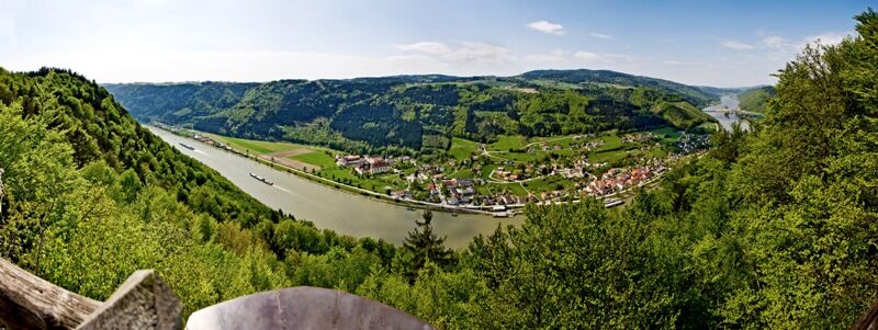
Varied hiking trail offering fantastic views, uphill and downhill sections with view of the Danube and hiking along Ranna River.
- Difficulty
-
medium
- Rating
-
- Starting point
-
Neustift
- Route
-
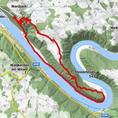
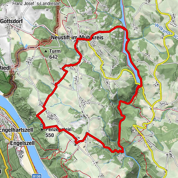
Neustift im MühlkreisGasthaus WundsamMausloch3.7 kmLackinger Baum6.1 kmLackinger Gruft6.5 kmSteinlacken7.6 kmPfarrkirche Rannariedl7.9 kmPühret8.1 kmPenzenstein (550 m)9.1 kmKleinmollsberg9.9 kmForstedt10.8 kmGrub11.8 kmGasthaus Wundsam12.9 kmNeustift im Mühlkreis12.9 km
- Best season
-
JanFebMarAprMayJunJulAugSepOctNovDec
- Description
-
· 0km Neustift.From the village centre you take the road out of the village (southwards) towards Niederanna Danube Bridge, then you take a right turn into the forestry trail to the village.
· 1.2km Grub. You hike on country lanes into a cutting and continue into the village.
· 2.1km Forstedt. (Accsess to Smugglers’ Trail with organized smugglers’ programme)
After Gasthaus Schürz you take a right turn into the asphalt trail (towards Donaublick Penzenstein vantage point), turn right again into the road between Klein- and Großsmollberg and follow it to Frauensteig junction; continue left to· 3.8km Donaublick Penzenstein. There you can enjoy the fantastic view of Danube Valley and the neighbouring village of Engelhartszell. The small chapel at the vantage point can be visited. Walk afterwards along the asphalt trail past the car park and through a forest section into the next village with the name of
· 5.3 km Pühret. Walk past the nice church towards Steinlacken, cross the road and take a right turn towards Rannatal Valley. The hiking route follows a forestry trail down to
· 8.2km Ranna River. Follow now Rannatalweg Trail through a varied nature area with vegetation zones that are very different from each other. From now on the trail leads into Rannatal Valley that has been put under protection order because of its rare fauna and flora. A hike through Rannatal Valley is a unique experience especially in spring and fall time. Follow the river upstream to the
· 8.2km dam. In spring time when the snow melts the Ranna Reservoir with its 45m-high dam overflows with water - an impressive spectacle. Like a white river brook the water flows through Rannatal Valley. Especially hikers, fishers and nature lovers appreciate Ranna Reservoir because of its peaceful setting. The hiking route leads along the right shore to
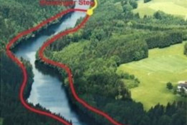
· 12.7km Konzinger Steg footbridge (access to Kneipp Hiking Trail) that connects the two shores of Ranna Reservoir. Having crossed the footbridge you turn right and after a brief uphill section you return back into the forest and to the starting point in the village centre of
· 14.1km Neustift.
- Highest point
- 601 m
- Endpoint
-
Ortsplatz Neustift (Startplatz des Donausteiges)
- Height profile
-

- Safety instructions
-
Hiking boots are recommended
- Tips
-
Donaublick Penzenstein vantage point
Several spots on the section between Pühret and Penzenstein
Dam
Kneipp and Fitness Trail
Rannatal Nature Reserve - Additional information
- Directions
-
By car:
From Austria: Voralpenkreuz - Welser Westspange - towards Eferding - Passau – Niederranna Danube Bridge - Neustift i.M.
or
Linz - Eferding or Aschach - towards Passau – Niederranna Danube Bridge - Neustift i.MBy train: nearest train station: Neufelden (33km)
Passau train station (Germany): 30km - Parking
-
Donaublick Penzenstein car park
Village of Neustift im Mühlkreis
At Ranna reservoir
Pühret
- Author
-
The tour Neustift: Bishop Firmian Trail is used by outdooractive.com provided.


General info
-
Innviertel
797
-
Ferienregion Böhmerwald
479
-
Neustift im Mühlkreis
160