- Brief description
-
Circular hike in the direction of Herndleck and via Saumarktbach and Riegler Seff through the Bäckengraben back.
- Difficulty
-
medium
- Rating
-
- Starting point
-
Ternberg/railway station
- Route
-
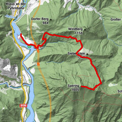
TernbergRieglergut8.2 kmTernberg14.0 km
- Best season
-
JanFebMarAprMayJunJulAugSepOctNovDec
- Description
-
There is a short and a long version of this circular hike. First, head towards Herndleck and return via a forest and meadow path at the Saumarktbach stream or via the Riegler Seff through the Bäckengraben.
Trail number: E86, E86a
- Directions
-
At the beginning, the trail leads in the direction of Herndleck and then branches off to the right into a forest path. At the Saumarktbach stream, the small loop turns off and leads back along a forest and meadow path on the right.
The large loop continues on a forest road to the junction of trail no. 13. From here, continue to Riegler Seff either via trail E86 or no. 13. The trail then continues on the asphalted path to the Schweinsegg fire station.
Here trail no. 13 branches off to the left in the direction of Gasthaus Sandner Linde. Return via the asphalted path to Bäckengraben and the starting point.
Alternative: At Schneeherrgott, you have the option of continuing along trail 409 to Kruckenbrettl and via Gscheid to Trattenbach or via Sulzboden to Grünburger Hütte.
- Highest point
- 761 m
- Endpoint
-
Ternberg/railway station
- Height profile
-

- Tips
-
Climate-friendly to the National Park Region - railway station Ternberg: By train you can reach the starting point for this hike in about 1 hour from Linz and in about 2.5 hours from Vienna.
- Directions
-
From Salzburg/Linz: A1 motorway exit Enns-Steyr > B115 into the Enns Valley.
From Vienna: A1 motorway exit Haag > B42 > B122 > B115 into the Enns Valley
From Passau: A8 Passau > Wels > A1 motorway exit Enns-Steyr > B115 into the Enns Valley
From Graz: A9 Pyhrnautobahn > motorway exit Klaus > Grünburg > into the Ennstal valley
- Public transportation
- Parking
-
Ternberg/parking at the railway station

- Author
-
The tour Bäckengraben Circular Trail is used by outdooractive.com provided.


General info
-
Traunviertel
1940
-
Steyr und die Nationalpark Region
1371
-
Ternberg
376