
- Brief description
-
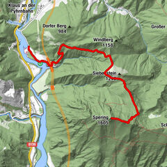
Circular hiking trail to the district Schattleiten and further to Dürnbach
- Rating
-
- Starting point
-
Ternberg/railway station
- Route
-
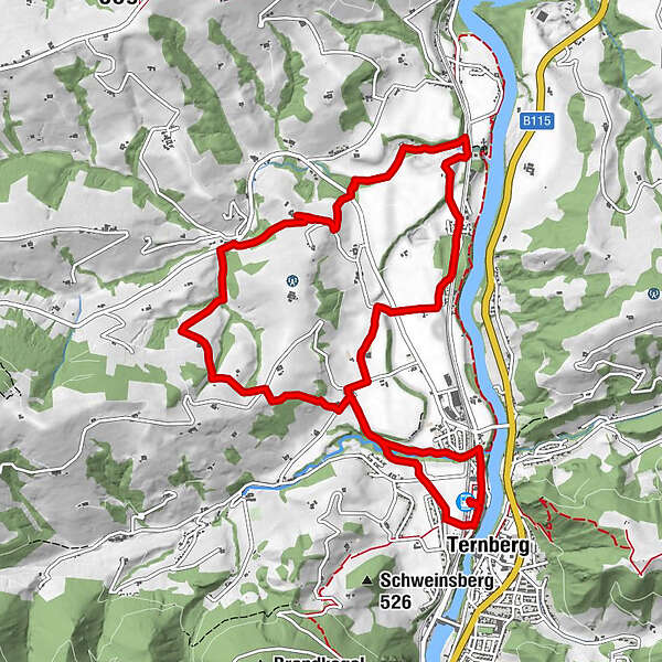
Ternberg0.0 kmTernberg0.3 kmSternwirt4.4 kmFaller Wasserfall7.4 kmTernberg11.8 km
- Best season
-
JanFebMarAprMayJunJulAugSepOctNovDec
- Description
-
The hiking trail leads from Ternberg train station along the Bäckengrabenbach stream to the Spielhofer Chapel and the Zeilermaier Chapel and past the Gasthaus Sternwirt to Dürnbach.
Trail number: E85
- Directions
-
The hiking trail leads along the Bäckengrabenbach stream to the Spielhofer Chapel in the Schattleiten district to the fire station and the Zeilermaier Chapel.
At the road on the right, the trail continues to the Sternwirt inn. After a short stretch on the country road, turn right across a meadow and through the forest to the composting plant. After a few meters, turn left again to the country road.
After crossing the road, the path leads flat along the Dambach to Dürnbach. The path leads back via the Mayr farmhouse to Dambach to the Spielhofer chapel and along the Bäckengrabenbach stream back to the starting point.
- Highest point
- 499 m
- Endpoint
-
Ternberg/railway station
- Height profile
-

- Tips
-
Climate-friendly to the National Park Region - railway station Ternberg: By train you can reach the starting point for this hike in about 1 hour from Linz and in about 2.5 hours from Vienna.
- Directions
-
From Salzburg/Linz: A1 motorway exit Enns-Steyr > B115 into the Enns Valley
From Vienna: A1 motorway exit Haag > B42 > B122 > B115 into the Enns Valley
From Passau: A8 Passau > Wels > A1 motorway exit Enns-Steyr > B115 into the Enns Valley
From Graz: A9 Pyhrnautobahn > motorway exit Klaus > Grünburg > into the Ennstal Valley
- Public transportation
-
The Ennstalbahn runs between Linz and Weißenbach-St. Gallen.
Details at www.ooevv.at
Railway Stations are located in Steyr, Garsten, Lahrndorf, Dürnbach, Ternberg, Trattenbach, Losenstein, Reichraming, Großraming, Gaflenz, Weyer, Küpfern, Kastenreith, Kleinreifling and Weißenbach-St. Gallen.
- Parking
-
Ternberg/parking at the railway station
- Author
-
The tour Ebenboden Circular Trail is used by outdooractive.com provided.


General info
-
Traunviertel
1940
-
Tourismusregion Bad Hall
770
-
Ternberg
376