- Brief description
-
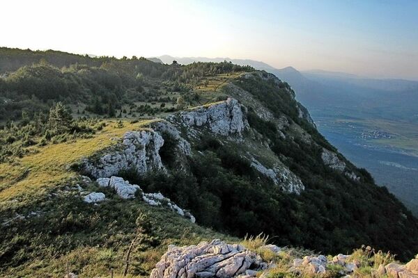
This trail will take you to some of the best views in Vipava Valley.
- Difficulty
-
medium
- Rating
-
- Starting point
-
The village of Razdrto has a large gravel parking lot right before the overpass over the highway
- Route
-
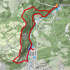
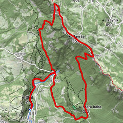
PrevalloPleša (1,262 m)2.5 kmVojkova koča na Nanosu2.6 kmPrevallo7.5 km
- Best season
-
JanFebMarAprMayJunJulAugSepOctNovDec
- Description
-
The most popular hiking trail in the Vipava Valley offers several difficulty levels for hikers of all experience levels. No matter if you’re a beginner or a pro, the summit provides you with breathtaking views of the Vipava Valley and the Adriatic Sea on one side, the Ljubljana basin on the other, and the majestic Julian Alps, with Mount Triglav as their crown jewel.
- Directions
-
The first steps from the parking lot head northward in the direction of Mount Nanos. Right across the overpass waits an intersection, which you should take left to get on a gravel road where there are signs pointing you towards the meadow. Continue along the well-trodden trail till the fork, where you can make the decision to take the easier, gentler path, or take the steep route, which has a few pins and metal cables drilled into the rock face. The steep trail on the right immediately serves up some great views of the Vipava Valley, the Karst Plateau, Vremščica, and Snežnik. Pleša (1262 m), just a few dozen meters from the Vojkova mountain hut, which is reached after an hour and a half of hiking along a well-marked trail. After reaching your destination you can take the easier trail back to the starting point and make a nice circle in doing so.
If you decide rather on the easier trail, go straight at the fork along the well-marked trail. At first you will be in the woods, but then the trees will get sparser as you are treated to the first views of the upper part of the Vipava Valley. After a good hour and a half you will be atop the Nanos Plateau, right above the church of St. Jerome. Continue on your right down to the Vojkova mountain hut.
- Highest point
- 1,242 m
- Endpoint
-
Razdrto
- Height profile
-
 © outdooractive.com
 - Equipment
-
Hiking boots and hiking poles
- Safety instructions
-
No special safety issues
- Directions
-
Starting point: the village of Razdrto has a large gravel parking lot right before the overpass over the highway.
- Parking
-
Starting point: the village of Razdrto has a large gravel parking lot right before the overpass over the highway.
- Author
-
The tour Nanos is used by outdooractive.com provided.


General info
-
Notranjsko-Kraška
68
-
Vipava
17