© Touristikverband Siegen-Wittgenstein e.V. - Sophie Manche

© Touristikverband Siegen-Wittgenstein e.V. - Sophie Manche

© Touristikverband Siegen-Wittgenstein e.V. - Sophie Manche

© Touristikverband Siegen-Wittgenstein e.V. - Sophie Manche

© Touristikverband Siegen-Wittgenstein e.V. - Sophie Manche


- Brief description
-
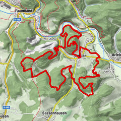
Der Rundweg führt entlang des Elberndorfer Tals durch den Fichten- und Buchenwald Erndtebrücks und umrundet den Bachlauf der Elberndorf.
- Difficulty
-
medium
- Rating
-
- Highest point
- 604 m
- Endpoint
-
Wanderparkplatz 'In der Elberndorf'
- Height profile
-
 © outdooractive.com


- Author
-
The tour Das Elberndorftal (A6) is used by outdooractive.com provided.
GPS Downloads


Other tours in the regions