© Teutoburger Wald/Bielefeld Marketing GmbH/T.Fröhlich, Tim Froehlich

© Teutoburger Wald Tourismus / D. Ketz, Dominik Ketz

© Teutoburger Wald Tourismus / T. Evers, Tanja Evers

© Teutoburger Wald/ Umweltamt der Stadt Bielefeld/ Hanne Wünscher

© Teutoburger Wald/Umweltamt der Stadt Bielefeld/Hanne Wünscher

© Teutoburger Wald Tourismus / P. Gawandtka, Patrick Gawandtka


- Brief description
-
Die Stadtwanderung führt von Bielefelds ländlich geprägtem Stadtrand durch Felder und Wiesen hinein in die Altstadt.
- Difficulty
-
easy
- Rating
-
- Route
-
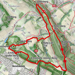
Bielefeld (118 m)10.3 kmMitte10.4 km
- Best season
-
JanFebMarAprMayJunJulAugSepOctNovDec
- Highest point
- 118 m
- Endpoint
-
StadtBahn Haltestelle Adenauerplatz
- Height profile
-
 © outdooractive.com


- Author
-
The tour Weser-Lutter-Weg is used by outdooractive.com provided.
GPS Downloads


General info
Insider tip
Other tours in the regions
-
Teutoburger Wald
726
-
Bielefeld
376
-
Oerlinghausen
118


Klein.jpg")