- Brief description
-
A stimulating hike over the Seebenstein Schlossberg to the artificial “Türkensturz” ruin – easily accessible by public transport!
- Difficulty
-
medium
- Rating
-
- Starting point
-
Seebenstein railway station
- Route
-
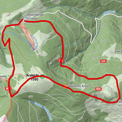
SeebensteinPizzeria zum Spitz0.1 kmSeebenstein0.6 kmSchwarze Höhle3.1 kmTürkensturz3.1 kmSollgraben4.3 kmTemplerhöhle6.8 kmSeebenstein7.1 kmZum Waldhaus7.4 km
- Best season
-
JanFebMarAprMayJunJulAugSepOctNovDec
- Description
-
Easily accessible – by train or car, and in this case even by coach – the starting point is at Seebenstein railway station, from where the route takes you further along the Bahnstraße. You reach the Parkbad, which provides the necessary cooling effect in summer. Via the new Schlossweg, you come across the Große Reit straight to the Türkensturz. The mountain ruin is not only a highlight in itself, but the view also captivates many hikers. After a relaxing rest amidst the old walls, the path continues towards the Sollgraben residential area with some farms. If you keep to the left in Sollgraben, you will sooner or later reach the Sollgrabner Alm. At the crossroads, take the forest path to the mountain castle, which brings you closer to the end of the hike. Finally, you can return to the Parkbad via the Alter Schlossweg (“old castle path”) or opt for the shorter variant via the Eselsteig (“donkey path”), both of which have their advantages. Those who want to end the day in a cosy atmosphere can get refreshments at the Pizzeria Schaffer “Zum Spitz”.
- Directions
-
From Seebenstein railway station, we start our tour along Bahnstraße towards the centre of the village until we reach the turn-off to the right to Parkbad. We move about 100 metres into the centre of the village on the “Neuer Schlossweg” trail. Our path leads us gently upwards to the Große Reit, and we continue straight ahead until we reach the Türkensturz. From the hut on the forest road, we hike eastwards to Sollgraben. We reach a barrier and follow the path to the left. The route continues uphill to the Sollgrabner Alm. We come to a prominent crossroads and take the forest path to the mountain castle. This is followed by the descent to Seebenstein via the Alter Schlossweg to the Parkbad. A tip for a shortcut would be to pass the Eselsteig instead of the Alter Schlossweg.
- Highest point
- 587 m
- Endpoint
-
outdoor pool Seebenstein
- Height profile
-

- Equipment
-
Always take suitable maps with you. Wear sturdy shoes suitable for the tour, take sun and rain protection, as well as water and a snack. Take your mobile phone with you and save the emergency number of the mountain rescue: 140
- Safety instructions
-
Your hikes in the Vienna Alps should be a beautiful and safe experience all-round. Therefore, please note the following:
Preparation
When choosing a route, make sure it suits your mountain experience and physical condition. Check the weather forecast in advance. The weather can change surprisingly quickly in the mountains. Therefore, always go equipped accordingly (e.g. rain protection).
Check whether the huts and snack stations you want to visit on the way are open. Inform someone about your choice of route and your planned return before you set off.
- Tips
-
Those who have climbed the “Türkensturz” should not miss the view from the “Luther Kanzel” behind the castle.
- Additional information
- Directions
-
Take the A2 in the direction of Seebenstein, exit and travel through the village of Seebenstein until you reach the turn-off for the outdoor pool (Parkbad).
- Public transportation
-
The station Wr. Neustadt is easily accessible by train from Vienna and Graz. From there, there are regular train connections to Seebenstein station, where the tour starts. Alternatively, the station can also be reached by buses of the VOR transport network.
More information on the timetable: fahrplan.oebb.at and anachb.vor.at
- Parking
-
Parking available at the station and at the Parkbad.

- Author
-
The tour Hike to Seebenstein Castle & the Türkensturz Ruin is used by outdooractive.com provided.


General info
-
Wiener Alpen
3036
-
Wechselland - Wiener Alpen
1697
-
Seebenstein
429