


- Brief description
-
The stage of the railway hiking trail leads from Semmering past the most impressive viaducts and buildings of the UNESCO World Heritage Site to Breitenstein station as an intermediate destination. A leisurely hike that has a lot to offer!
- Difficulty
-
medium
- Rating
-
- Starting point
-
Semmering railway station
- Route
-
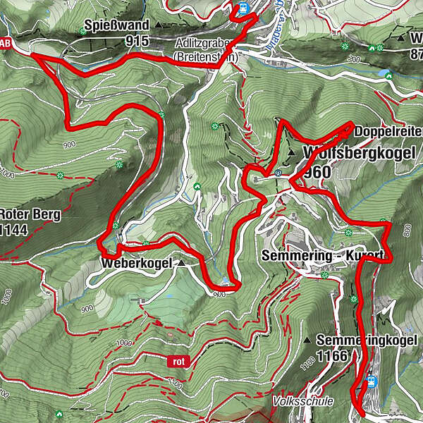
SemmeringSemmering - Kurort1.2 kmKartnerkogel (974 m)1.2 kmDoppelreiterkogel3.0 km20-Schilling-Blick3.7 kmAusschank Hinterholz5.4 kmFotopunkt Viadukt Kalte Rinne, Ghega Museum8.0 kmAdlitzgraben (Breitenstein)9.4 kmZum Blunzenwirt9.4 kmBreitenstein9.9 kmFilialkirche Breitenstein10.1 kmBreitenstein10.2 km
- Best season
-
JanFebMarAprMayJunJulAugSepOctNovDec
- Description
-
Railway hiking trail
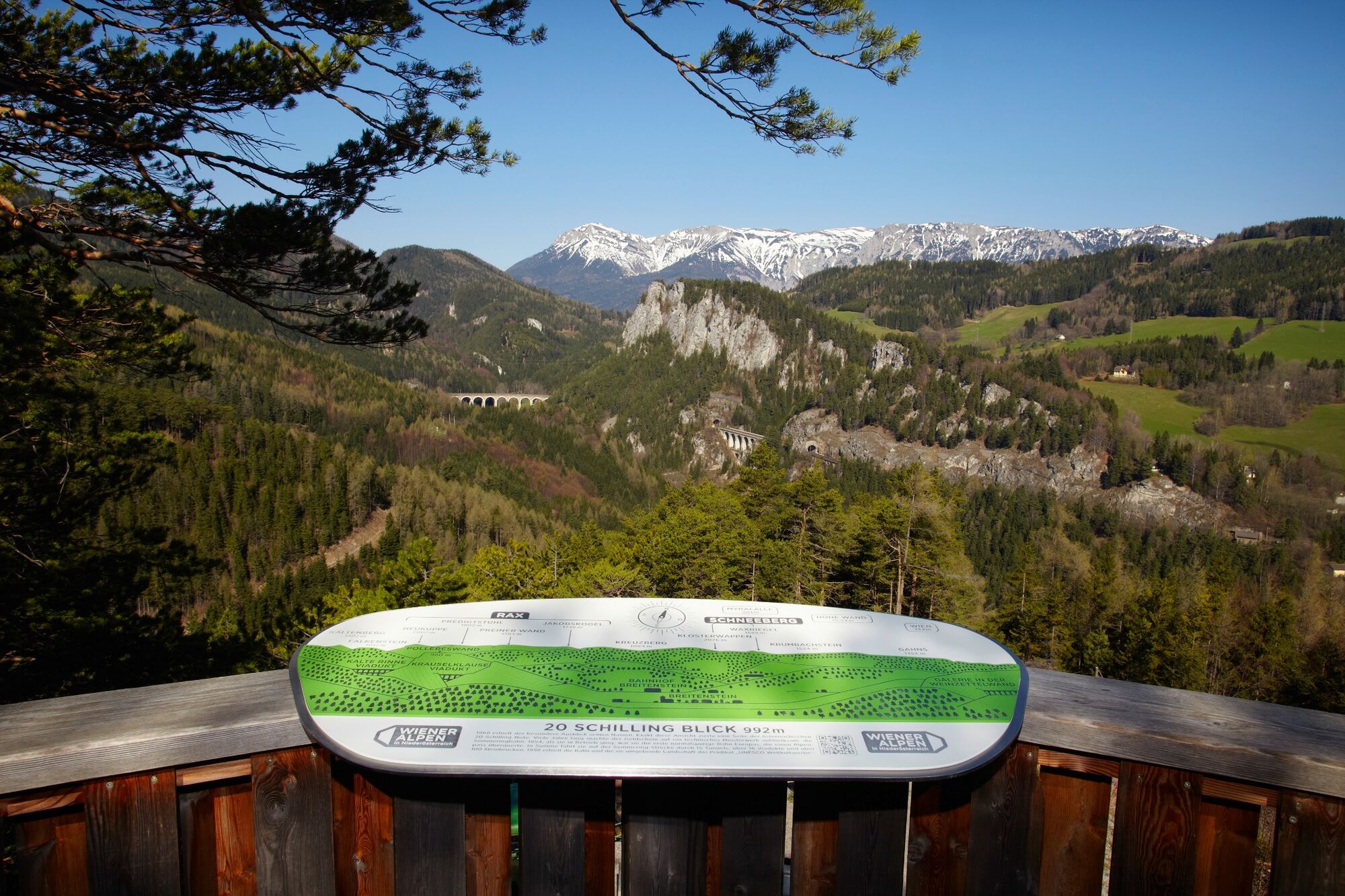
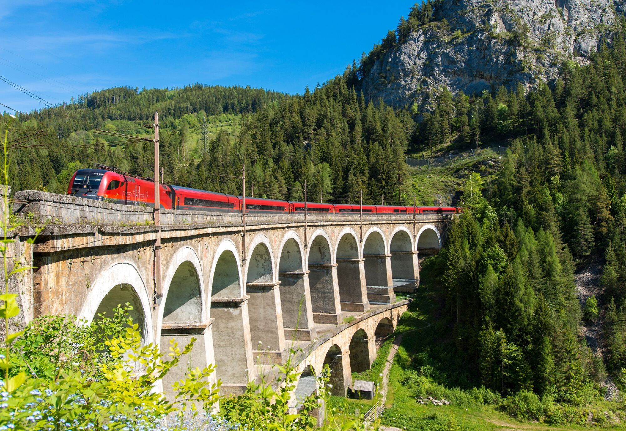
The hike starts at Semmering railway station and leads along the UNESCO World Heritage Semmering Railway. Information boards and beautiful viewpoints accompany the entire route. From Semmering station, the trail leads along the railway body to Wolfsbergkogel station. At the Doppelreiter lookout, you can enjoy a panoramic view of the imposing viaducts and tunnels with the Rax and Schneeberg mountains in the background. From here, trains can be observed on their journey over the most imposing structure of the Ghegabahn, the "Kalte Rinne". The "20 Schilling View" (named after the motifs of the 20 Schilling note) is a must. The trail continues to the Fleischmann Bridge, the "Red Mountain" along the railway road, from the "Cold Gully" the trail leads along the upper Adlitzgraben road, past the Iron Cross, to Breitenstein. You can return to the starting point or continue on to Payerbach and Gloggnitz comfortably with the Semmering Railway or on hiking trails along the railway.
History
In the beginning it was a path that led over the Semmering Pass - evidence of this has existed since the Middle Ages. Then, in the early 18th century, Emperor Charles VI had a road built with a gradient of up to 17 percent, over which horses laboriously struggled with their loads. Finally, in 1841, the order was given to build a railway line from Vienna to Trieste to meet the transport needs of the beginning industrialisation. Finally, in 1844, it was "only" a matter of closing the gap between Gloggnitz and Mürzzuschlag via the Semmering. Under the direction of Carl Ritter von Ghega, 20,000 workers finally built Europe's first full-track mountain railway, which has undergone only a few changes to this day. On the 41 km long line, the trains travel over 16 viaducts, 100 bridges and through 15 tunnels. Since 1998, this "outstanding technical solution to a major physical problem in the construction of early railways" has been a UNESCO World Heritage Site.
- Directions
-
We start at the Semmering railway station (895 m) and walk along the railway body to the Wolfsbergkogel railway station (1.5 km). Immediately afterwards we reach the Doppelreiter lookout (919m). Our next stop is the well-known "20 Schilling View". We rejoin the path along the railway track and pass the Lower Adlitzgraben Viaduct (Fleischmann Viaduct) and then walk over the "Red Mountain" which leads us to the Kalte Rinne Viaduct. We turn right onto the Kalte Rinne road and past the Krausel-Klause viaduct we follow the path to Breitenstein station (779 m).
- Highest point
- 972 m
- Endpoint
-
Breitenstein railway station
- Height profile
-

- Directions
-
From Vienna, take the A2 Südautobahn to the S6 Semmering-Schnellstraße and take the Maria Schutz exit. Turn right onto L4168. Continue on Semmering/L4168 and Semmeringstraße. Turn right onto Bahnhofstraße.
From Graz take the S6 Semmering motorway and exit at Spital/Semmering. Turn left onto Semmering Ersatz Str./B306. Continue on B306. At the roundabout drive straight ahead to Semmering. Continue on Passstraße, this runs slightly to the right and becomes Semmering. Turn left onto Bahnhofstraße.
- Public transportation
-
Arrival:
Take the train to Semmering station, the starting point of the tour.
Return journey:
The return journey is either by regional bus 1754 or by the RUFbus Semmering-Rax to the starting point of the railway hiking trail or by train from Breitenstein station back home.
TIP: Simply book the RUFbus with the Postbus Shuttle app, via your accommodation or the tourist offices and travel individually.
More information and timetables can be found at fahrplan.oebb.at and anachb.vor.at
- Parking
-
Free parking is available at the Semmering train station.


- Author
-
The tour Railway hiking trail: Semmering-Breitenstein is used by outdooractive.com provided.


General info
-
Hochsteiermark
4083
-
Semmering - Rax
2314
-
Breitenstein
866


