Tour data
10.36km
792
- 862m
184hm
183hm
03:00h

- Brief description
-
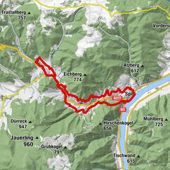
Ausgangspunkt: Johannesgasse
Streckenlänge: 9,8 km, Gehzeit: 3 Std.
Streckencharakteristik: 50 % Forst/Güterwege, 40 % Wald/Wiesenweg, 10 % Asphalt - Difficulty
-
medium
- Rating
-
- Starting point
-
Johannesgasse in Ottenschlag
- Route
-
OttenschlagSchmalzlüß6.7 kmDachsberg (877 m)6.7 km
- Best season
-
JanFebMarAprMayJunJulAugSepOctNovDec
- Highest point
- 862 m
- Endpoint
-
Johannesgasse in Ottenschlag

GPS Downloads


Trail conditions
Asphalt
(10 %)
Gravel
Meadow
(40 %)
Forest
(50 %)
Rock
Exposed
Other tours in the regions
-
Waldviertel
1776
-
Waldviertel Mitte
1247
-
Ottenschlag
250