- Brief description
-
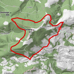
The 7.6 km long circular walk via Blümelsberg and back to the monastery in Seitenstetten provides a beautiful view of Seitenstetten and the surrounding communities.
- Difficulty
-
easy
- Rating
-
- Starting point
-
Seitenstetten
- Route
-
SeitenstettenWildheuriger Kronawetter3.1 kmBlümelsberg (527 m)3.5 kmSeitenstetten7.2 km
- Best season
-
JanFebMarAprMayJunJulAugSepOctNovDec
- Description
-
From the starting place begin walking Southeast past the abbey car park and along the Franzosenweg (path) (about 700 m) - continue to the crossroads at the Franzosenwald (forest) (watchable nature trail) - take the left track to the Rotte (tiny village) "Hofing" - here turn right - move along the paved road "Steingrub" (around 2 km) - continue up to the farm and uphill past a deer park and the Wild-Mostheurigen (farm/inn) "KRONAWETTER" - Move up along to the height Blümelsberges magnificent view - then downhill to the farm "Blümelsberg" - past the farm continue up to the next crossroads - turn left down following the valley road through a small forest to the State Road - turn left - on this road continue straight out towards Seitenstetten (about 1.5 km) - continue past a forest (Haiderwald), to the Haider houses, the Schintinger-Kapelle (chapel), and Dachsbach-Siedlung (settlement) - reach the right-sided Birkenalle (avenue) (entrance to the Biberbachstraße (road)) - turn left on to a meadow trail and continue back to the starting point.
- Directions
-
From the starting place begin to the Southeast at the abbey car park past the Franzosenweg (path) (about 700 m) - continue to the crossroads at the Franzosenwald (forest) (watchable nature trail) - take the left the track to the Rotte (tiny village) "Hofing" - here turn right - move along the paved road "Steingrub" (around 2 km) - continue up to the farm and uphill past a deer park and the Wild-Mostheurigen (farm/inn) "KRONAWETTER" - Move up along to the height Blümelsberges magnificent view - then downhill to the farm "Blümelsberg" - past the farm continue up to the next crossroads - turn left down following the valley road through a small forest to the State Road - turn left - on this road continue straight out towards Seitenstetten (about 1.5 km) - continue past a forest (Haiderwald), to the Haider houses, the Schintinger-Kapelle (chapel), and Dachsbach-Siedlung (settlement) - reach the right-sided Birkenalle (avenue) (entrance to the Biberbachstraße (road)) - turn left on to a meadow trail and continue back to the starting point.
- Highest point
- 515 m
- Height profile
-

- Equipment
-
comfortable shoes
- Tips
-
After the tour you can find rest in the Mostviertlerwirt (inn) Ott in Seitenstetten, or visit the historic rose garden of the Stift (abbey). The entrance is free.
- Additional information
-
www.seitenstetten.gv.at, www.stift-seitenstetten.at
- Directions
-
Coming from Vienna: on the A1, exit Oed, follow the B1 and L84 to Aschbach-Markt, from there via the B122 direction Steyr you reach Seitenstetten
Coming from Salzburg: exit A1 Stadt Haag follow signs to Seitenstetten
- Public transportation
-
With the Westbahn train to the Bahnstation (train station) St. Peter-Seitenstetten. From the train station there is a bus connection to Seitenstetten.
- Parking
-
Parking lot is at the Stift (abbey) Seitenstetten, aswell as at the Meierhof
- Author
-
The tour Panoramablick (Mostobstwanderweg) is used by outdooractive.com provided.


General info
-
Traunviertel
1940
-
Moststraße
754
-
Seitenstetten
181