- Brief description
-
Wonderful snowshoe hike on Kampstein starting at the family arena and the possibility of a round trip.
- Difficulty
-
medium
- Rating
-
- Starting point
-
Unternberg (Family area)
- Route
-
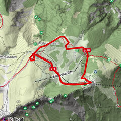
Unternberg0.0 kmAbenteuerspielplatz1.9 kmAlmrauschhütte2.5 kmKampstein (1,467 m)5.4 kmHerrgottschnitzerhütte6.4 km
- Best season
-
AugSepOctNovDecJanFebMarAprMayJunJul
- Description
-
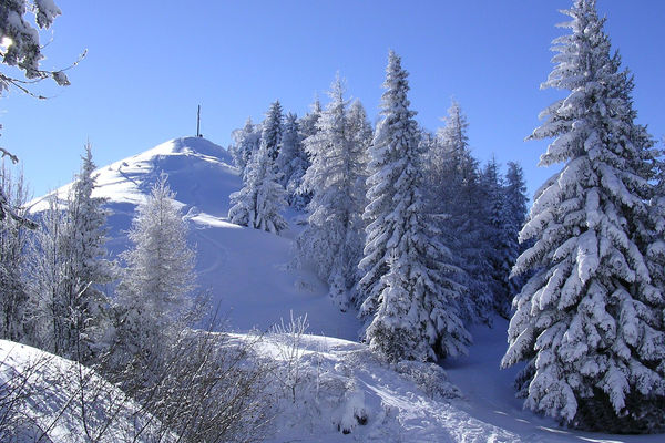
At the starting point of the tour in the family arena there is also a winter sports rental. From Unterberg, a district of St. Corona, it goes uphill. On the hike you will pass many beautiful places, like the reservoir of St. Corona, the Almrausch hut (closed November to April, except fair weather) and the Kampsteiner Schwaig (please call for opening times in winter) with breathtaking views of Schneeberg and Hohe Wand. The highlight of the tour is the summit of Kampstein at 1467 metres above sea level. From now on it goes comfortably downhill, past the Herrgottschnitzer-Franz Kaupe-House, which is also open in winter (day of rest Tuesday), to the destination of the hike, the Orthof. From here you can get to the centre of St. Corona or you can turn off before and return to the starting point in Unternberg. Here you will find numerous places to stop for refreshments and overnight stays such as the Fahrner country inn, the Gruber-List holiday home, the Ofnerhof, the Lehnerhof or the Dissauer farm.
- Directions
-
The starting point for the snowshoe hike is the St. Corona family arena. East of the lower station we will turn right up from the road. We continue walking straight up (right at the first two forks, left at the next three and right at the end) until our route crosses the road. We go straight on and follow the path left past the reservoir and then right to the Almrausch hut. Turn right onto the road and follow it for about one kilometre. The road now runs in a right-hand bend. Here we can take a shortcut via a path that leads straight ahead and get to the Kampsteiner Schwaig. From here we will go east over the Kampstein summit to the Herrgottschnitzer hut. Here we will turn left down to the upper station of the Sima lifts. Passing the lifts, we will turn right and arrive at the road that takes us to our destination, Orthof.
- Highest point
- 1,462 m
- Endpoint
-
Orthof (St. Corona)
- Height profile
-

- Equipment
-
You need a sporty winter garment (waterproof, windproof and breathable), firm and waterproof winter or hiking boots reaching over your ankle, gloves, a winter hat and sunglasses. A backpack with granola bars and drinks in a thermos for the trip, spare clothes to change, balaclava and a second pair of gloves (mittens), ski goggles and sunscreen.
- Safety instructions
-
Mountain rescue emergency number: 140 EU emergency number: 112
Lawineninfo: www.lawinenwarndienst-niederösterreich.at
Your hiking experience in the Vienna Alps should be a thoroughly enjoyable and safe one. Therefore, please bear the following in mind: Preparation: When choosing a route, make sure it corresponds to your experience and physical fitness level. Check the weather forecast before you set off. The weather can change surprisingly quickly in the mountains. Always take appropriate equipment with you (e.g. rain protection).
Check whether the cabins and snack stations you intend to visit along the way are open. Inform someone before you set off of your chosen route and when you plan to return.
- Tips
-
Combine your hike with a stay in the Wechsel-region, for example at the holiday home Gruber-List or at Ofnerhof in Unternberg!
- Additional information
-
Wiener Alpen in Niederösterreich Tourismus GmbH, +43 2622/78960, www.wieneralpen.at
- Directions
-
From Vienna take the A2 Südautobahn, exit at Edlitz. Drive in the direction of Aspang. Continue on Wechsel Straße/B54 to Aspang. At the roundabout take the third exit (Gutenberggasse). Turn right onto Bahnstraße. Turn slightly right onto Mühlgasse, Mühlgasse runs slightly to the right and becomes Sonneck. Continue on L137 to Unternberg.
- Public transportation
- Parking
-
Parking is available at the Fahrner inn or at the lower station of the family ski arena.

- Author
-
The tour Snowshoeing: Kampstein loop is used by outdooractive.com provided.