- Brief description
-
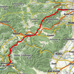
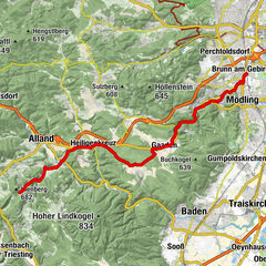
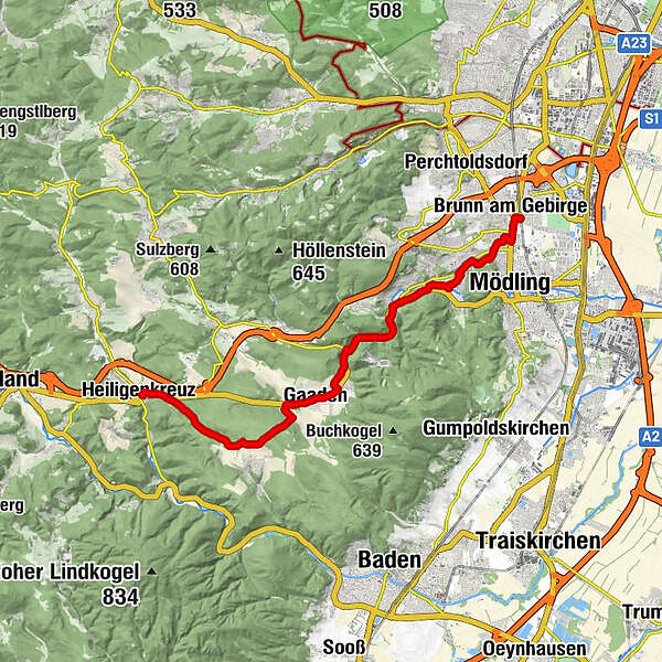
Brunn am Gebirge* – Maria Enzersdorf – Hinterbrühl – Heiligenkreuz
- Difficulty
-
medium
- Rating
-
- Starting point
-
Brunn am Gebirge
- Route
-
Brunn-Maria EnzersdorfBrunn am Gebirge0.2 kmFranziskaner- und Wallfahrtskirche Maria Enzersdorf0.7 kmMaria Enzersdorf0.9 kmMödling2.1 kmHotwagner2.9 kmWagnerkogel (299 m)3.6 kmSeegrotte4.2 kmHinterbrühl4.8 kmHinterbrühler Felsentor5.2 kmHöldrichsmühle6.0 kmGasthaus zu den Linden10.1 kmGasthaus zur Krone10.2 kmGaaden11.0 kmHonigspitz (343 m)11.5 kmXI Statio17.6 kmX Statio17.6 kmXIII Statio17.6 kmXIIII Statio17.6 kmIX Statio17.6 kmKalvarienberg (346 m)17.6 kmXII Statio17.6 kmVIII Statio17.7 kmVII Statio17.8 kmVI Statio17.8 kmV Statio17.8 kmIIII Statio17.9 kmIII Statio17.9 kmII Statio17.9 kmI Statio18.0 kmHeiligenkreuz18.0 kmKellerstüberl18.0 kmKlostergasthof18.1 km
- Best season
-
JanFebMarAprMayJunJulAugSepOctNovDec
- Description
-
From Brunn am Gebirge railway station, the path leads along Enzersdorferstraße to Maria Enzersdorf. After passing the Franciscan Church (pilgrimage church "Maria Heil der Kranken"), turn right into Mariazellergasse. Passing the former Pfandl fountain, you come to Liechtensteinstraße, where you can see the park of Hunyadi Castle on the left and diagonally opposite the "Schiffersäule", the oldest pilgrimage monument on the way to Mariazell. At the end of Liechtensteinstraße, at a Mariazell motif donated by Emperor Ferdinand, you come across Johannesstraße, which you follow to the holiday cross chapel (01:00 h). This has always been an important reference point for Mariazell pilgrims. The trail now runs downhill to the Seegrotte and through Hinterbrühl (01:00 h). At the Höldrichsmühle mill, you turn onto a forest path that leads into the Mödlingbachtal valley, where you walk partly beside the road, partly on footpaths to Gaaden (01:45 h). From the Gaaden Jakobskirche (St. James' Church), the trail turns right along the road to the west to the Gaaden Calvary. The trail then continues along the road for a short distance and crosses it to the south. Now the pilgrims' path leads across fields and through the forest towards Siegenfeld and past the "White Cross" to Heiligenkreuz. Via the baroque Calvary you come down to the monastery (02:15 h).* Historically, the Via Sacra in Vienna begins at the Paulanerkirche. It used to lead via the Spinner am Kreuz into the Vienna Woods to Heiligenkreuz and on to Mariazell.
- Highest point
- 430 m
- Endpoint
-
Heiligenkreuz
- Height profile
-

- Equipment
-
Appropriate hiking equipment is required. In addition, it should be taken into account that this is a hike lasting several days.
- Safety instructions
-
Walking times: The walking times given were calculated on the basis of the table of the German Alpine Association. These are pure walking times, rounded to the nearest quarter of an hour.
- Tips
-
Places of interest: Franciscan Church Maria Enzersdorf, Urlaubskreuzkapelle, Tree of Reconciliation, Höldrichsmühle, Cistercian Abbey Heiligenkreuz
- Directions
-
From Vienna:Südautobahn A2 direction Linz - continue on Wiener Außenring Autobahn A21 direction Linz/St. Pölten - exit Brunn am Gebirge.Express train lines S2 or S3, bus.

-

-
AuthorThe tour Via Sacra: Stage 1/5: Brunn - Heiligenkreuz is used by outdooractive.com provided.


General info
-
Wienerwald
4219
-
Wien und Umgebung
2481
-
Gaaden
988