- Brief description
-
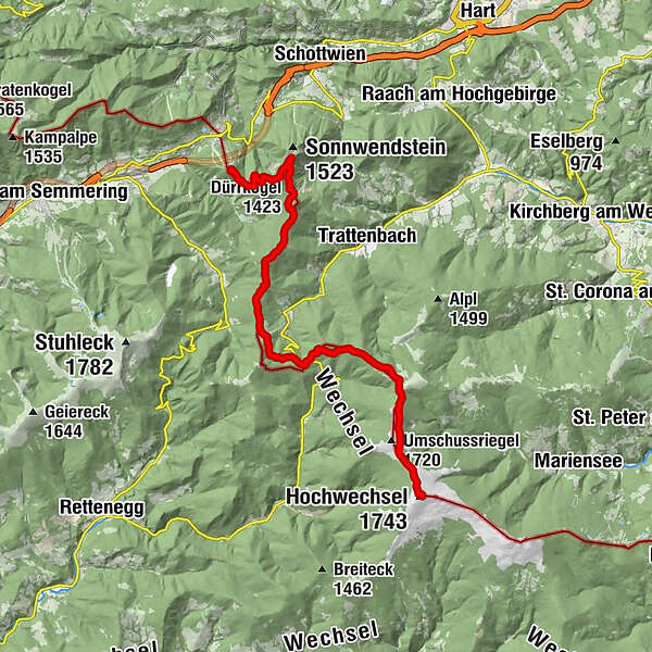
alpannonia is a 100 - 120 km long (depending on the variant chosen) long, continuously marked and signposted high-altitude and panoramic trail. Numerous feeder stations along the entire route make it easier to get started and also enable individual day tours. The entire route leads in five to six daily stages, initially from the alpine area of Peter Rosegger's forest home or from Semmering through the East Styrian Joglland to the Hochwechsel. We continue into the wooded low mountain ranges of the Buckligen Welt as well as the Bernstein and Günser Mountains to the vineyards near Köszeg. Stage 1: Semmering - Hochwechsel Length: 19.5 km Rising time: 6 hours
- Difficulty
-
medium
- Rating
-
- Starting point
-
Semmering - Zauberbergbahn valley station
- Route
-
Erzkogel (1,504 m)3.7 kmPoirhöhe (1,374 m)7.1 kmFanklbauerhöhe (1,304 m)8.7 kmFröschnitzsattel (1,273 m)9.3 kmKönigsbrünnlein10.0 kmSt.Wolfgangs-Kapelle10.1 kmKranichberger Schwaig15.5 kmDreiländereck15.9 kmHochwechsel (1,743 m)19.5 kmWetterkoglerhaus19.6 km
- Best season
-
JanFebMarAprMayJunJulAugSepOctNovDec
- Description
-
The remaining stage of a cross-border hiking trail system between Semmering, Fischbach and Köszeg, consisting of a main trail of around 120 km and several feeder trails from the towns at the foot of the mountain groups, which are also often used as circular trails. Thanks to additional equipment at various sections and points and the integration of existing attractions, you can expect an exciting hiking experience.
- Directions
-
The starting signal for the alpannonia® long-distance hiking trail at Semmering begins in an alpine, yet leisurely manner. With the Zauberberg gondola you can overcome the first 300 meters in altitude in an enjoyable way. When you arrive at the summit of the Hirschenkogel, you can immediately enjoy a top-class mountain panorama - even better from the observation tower built right next to the mountain station of the gondola. The Hirschenkogel and the observation tower can of course also be reached via an easily accessible hiking trail from Semmering without using the gondola. The following stage runs up and down to the Feistritzsattel over alpine meadows and through forests, always with beautiful close-up views of Stuhleck, Hochwechsel and the Styrian - Lower Austrian limestone Alps. After the Feistritzsattel you reach the 1,743 m high Hochwechsel with the Wetterkoglerhaus, our first stage end point, over gently rising alpine pastures (so-called “Schwaigen”). Semmering (995 m) Hirschenkogel (1,340 m) - Hochwechsel/Wetterkoglerhaus (1,743 m) Length: 19.5 km Duration: 6 hours Altitude ascending/descending: 772 m / 354 m Condition: **** Technology: *** Experience value: **** Landscape: ****
- Highest point
- 1,733 m
- Endpoint
-
Hochwechsel - Wetterkoglerhaus
- Height profile
-

- Equipment
-
Small backpack with drinking bottle (provisions) Sturdy shoes Appropriate clothing - several layers if possible - "onion principle" Rain and sun protection Hiking poles as required Mobile phone Small first aid kit Directions Before starting the hike, check rest stops including opening times or pack appropriate food.
- Safety instructions
-
Euro emergency call: 112Emergency call mountain rescue: 140 (if possible, please provide GPS data)Rescue: 144Fire department: 122Police: 133 A few tips on correct and fair behavior in the forest: (Source: www.bundesforste.at) Hikers should visit the forest approx. Avoid 1.5 hours before sunrise and after sunset, as wild animals are particularly active at this time. Plastic bottles, handkerchiefs, cigarette butts, etc. have no place in the forest! Please make sure that you do not leave any rubbish in the forest. Camping and making fires is strictly forbidden in the forest! In principle, each person in the forest is allowed to collect 2 kg of mushrooms and berries per day for their own use. It is only forbidden if the forest owner expressly prohibits it.
- Tips
-
Panorama - circular tour Semmering - Feistritzsattel - Stuhleck - Pretul - descent to Mürzzuschlag and back with ÖBB or bus to Semmering.
- Additional information
-
You can find information about the region, places to stop and stay overnight, excursion destinations, etc. here: Eastern Styria Tourism Association Office Joglland-WaldheimatKirchenviertel 248255 St. Jakob im WaldeTel.: 03336
www.alpannonia.at The Steiermark Tours app, which is available free of charge on Google Play and the App Store (Android, iOS), offers detailed first-hand information: short facts (length, duration, difficulty, ascent and descent in altitude, reviews), map, directions , altimeter, compass, summit finder, navigation along the tour. You can also create your personal favorites list of favorite tours and points, save tours and excursion destinations offline, use social media channels and more.
- Directions
-
From Vienna via the A2 southern motorway and the S6 Semmering expressway to the Semmering exit. Now continue to the marked parking lot at the Zauberberg/cable car valley station. From Graz, Linz and Salzburg/Germany via the Pyhrnautobahn A9 and the Semmeringschnellstrasse S6 to the Spital am Semmering exit. Now take the main road up to the Semmering pass. Continue as above.
- Public transportation
- Parking
-
Directly at the valley station of the Zauberbergbahn.


- Author
-
The tour alpannonia stage Semmering - Hochwechsel is used by outdooractive.com provided.


General info
-
Hochsteiermark
4082
-
Semmering - Rax
2314
-
Trattenbach - Feistritzsattel
670