- Brief description
-
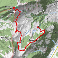
The Bonistock circular tour at Melchsee-Frutt offers spectacular views of impressive rocky landscapes and mountain lakes, as well as unique alpine flora.
- Difficulty
-
medium
- Rating
-
- Starting point
-
Melchsee-Frutt: old upper terminus
- Route
-
Obere Frutt0.4 kmBonistock (2,160 m)2.0 kmBonistock (2,169 m)2.3 kmTannenschild (2,181 m)2.7 kmTannalp (1,974 m)5.2 km
- Best season
-
JanFebMarAprMayJunJulAugSepOctNovDec
- Description
-
The route starts at the old upper terminus at Melchsee-Frutt. The path leads along the road up to the Hotel frutt Lodge & Spa and changes behind the building to the path towards Bonistock. On the way, look out for the varied alpine flora. The striking karst landscape with its bizarre rock formations is also a feature of this stretch. The ascent to the Bonistock is rewarded with a fantastic panoramic vista of central Switzerland all the way to the border with Germany and the imposing peaks of the Bernese Alps. From here, the trail continues flat to the Chringen crossing and from there downhill towards Tannalp.
On the way back, the Fachshubel barbecue spot near Lake Tannen invites you to take a break. The route leads back along the road to the Tannen dam and from there follows the footpath via the Panorama Lift back to Frutt.
- Highest point
- 2,167 m
- Endpoint
-
Melchsee-Frutt: old upper terminus
- Height profile
-
 © outdooractive.com
 - Tips
-
The walk back to Frutt can be shortened by taking the Frutt-Zug road train from Tannalp.

-

-
AuthorThe tour Bonistock circular tour is used by outdooractive.com provided.


-
Obwalden
2014
-
Melchsee - Frutt
861
-
Gadmen
173