
- Brief description
-
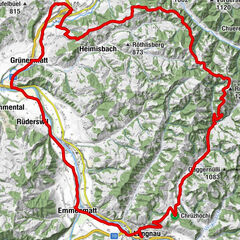
Cycle from picturesque Willisau over the heights of the Oberaargau into the Emmental.
- Difficulty
-
difficult
- Rating
-
- Starting point
-
bicycle station Willisau or Langnau
- Route
-
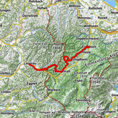
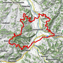
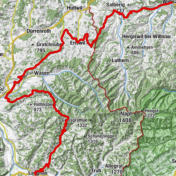
Willisau (557 m)0.0 kmHeiligblut0.7 kmKäppelimatt2.0 kmRufswil (654 m)8.0 kmMühlematt9.9 kmHegen15.1 kmHitzenberg (860 m)15.7 kmOberthalweid16.0 kmNeuligen16.8 kmStegmatt18.0 kmScheuerbifang18.3 kmStutz18.4 kmGasthof Alpen18.7 kmEriswil18.8 kmSchynen19.7 kmLangetschwand20.3 kmStutz21.0 kmHueb21.6 kmRyftal21.9 kmChäppihof22.5 kmWyssachen22.5 kmGasthof Rössli22.6 kmLindehof22.6 kmPfarrhus22.7 kmKirche Wyssachen22.8 kmSonnrain23.1 kmStäublere23.1 kmChnubelacher23.3 kmWisli25.1 kmWisli25.4 kmOberwald25.7 kmRestaurant Hirschen Oberwald25.8 kmKaschishaus27.5 kmSattlershaus28.1 kmBützen28.8 kmOber Steg29.0 kmSchonegg30.0 kmOber Kneubühl30.4 kmDLZ Dachrestaurant33.0 kmGasthof zum Kreuz33.3 kmReformierte Kirche33.4 kmSumiswald33.4 kmLandgasthof Bären33.5 kmGrünen34.4 kmTrachselwald35.7 kmChlösterli36.1 kmSchlossberg36.2 kmSteinweid38.3 kmWäberhüsli38.9 kmSänggeberg41.5 kmLüdernalp45.3 kmBärnsicht Lüderenalp45.5 kmGmünde49.7 kmObeningohl51.6 kmFansrüti55.6 kmLangnau57.7 km
- Best season
-
JanFebMarAprMayJunJulAugSepOctNovDec
- Description
-
The journey from Willisau to Langnau over the foothills of the Napf is a delight. The route approaches the cascades of hills and always finds a clever way around them. Only after the Luthertal does the route lift and lead to a magnificent vantage point from which one can look far out into the Mittelland. Free of traffic, one revels in the lovely hillside scenery that one sweepingly circles. Soon you reach the cantonal border and can enjoy the regions of Oberaargau and Emmental. In Sumiswald, the Emmental becomes a defining experience, with its increasingly hilly passages. The FLYER masters the ramps with assurasnce and we enjoy the origin of this rich region, which rises to over 1100 meters as far as Lüderenalp. Here you can feel it, this Napf power, as it seeps out of the landscape and enchants our senses. An epic descent takes us to Langnau, the center and paradise of the Emmental.
- Highest point
- 1,141 m
- Endpoint
-
bicycle station Langnau or Willisau
- Height profile
-
 © outdooractive.com
 - Equipment
-
e-bike reservations recommended at rentabike.ch
- Tips
-
Make a short stop in Trachselwald and enter the public courtyard of the beautiful "Schloss Trachselwald".
- Additional information
-
The route is signposted in both directions as Route 399 «Herzschlaufe Napf». Have a look at the Herzroute website? herzroute.ch
Note: There may be significant deviations in the indication of the altitude difference between SchweizMobil and Outdooractive. This is based on a differently resolved terrain model, while SchweizMobil is already taking in consideration small differences. - Public transportation
-
Arrival by train ideal, rental station is about a 10' walk to train station.


-

-
AuthorThe tour Herzschlaufe Napf Etappe Willisau - Langnau #399 is used by outdooractive.com provided.


General info
-
Solothurn und Region
142
-
Emmental
65
-
Eriswil
22