- Brief description
-
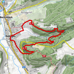
Circular walk Mamer II
- Difficulty
-
easy
- Rating
-
- Starting point
-
Car park at the end of the rue Baumbusch
- Best season
-
JanFebMarAprMayJunJulAugSepOctNovDec
- Description
-
We follow the cycle path along the Bambësch and pass iewescht Bruch before we enter the Déckebësch forest. We walk as far as the motorway and follow the railway line before we return across fields and through the forest to the starting point.
- Highest point
- 338 m
- Endpoint
-
Car park at the end of the rue Baumbusch
- Height profile
-
 © outdooractive.com
 - Equipment
-
Sturdy shoes and some water.
- Additional information
- Parking
-
A parking place is located directly at the starting point.


- Author
-
The tour Auto-pédestre trail Mamer II is used by outdooractive.com provided.
GPS Downloads


Other tours in the regions