- Brief description
-
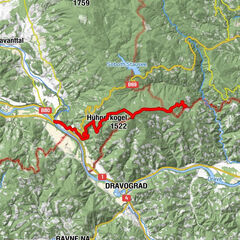
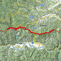
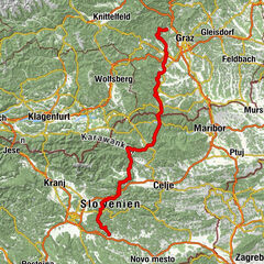
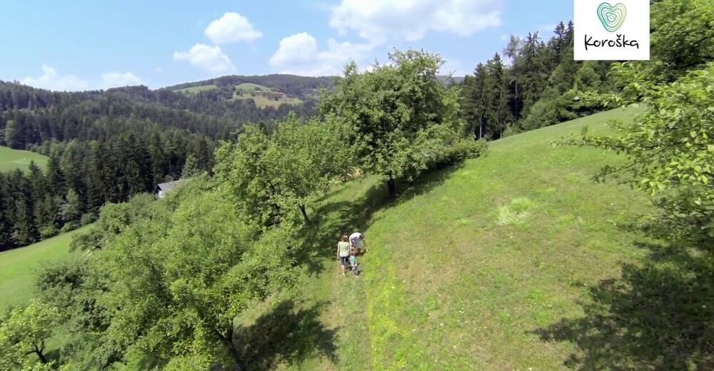
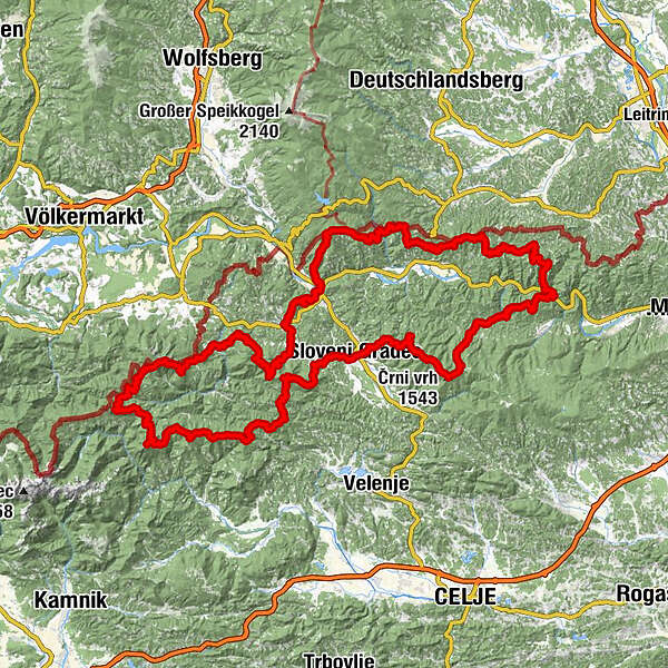
A long-distance circular trail that leads along the hillsides of three valleys in Koroška: Meža, Drava and Mislinja river valleys. It is 230km long and takes about 10-12 days.
- Difficulty
-
medium
- Rating
-
- Starting point
-
Ravne na Koroške (bus station)
- Route
-
Ravne na KoroškemSv. Križ7.8 kmDobrova pri Dravogradu8.4 kmDravograd (390 m)10.8 kmLovska koča Košenjak17.7 kmPlaninski dom Košenjak (1,169 m)18.4 kmJantschkifels (1,368 m)22.6 kmKozji vrh (1,383 m)24.7 kmSveti Simon in Juda Tadej26.9 kmSankt Bartholomä34.2 kmNandl34.4 kmBricnik (1,017 m)38.8 kmŽohar45.4 kmKapunar (1,051 m)50.3 kmSveti Urban52.2 kmRemšnik56.5 kmKapla na Kozjaku65.2 kmSršenov vrh (965 m)67.4 kmSt. Oswald im Drauwald75.0 kmGlančnik (877 m)82.7 kmGostilna-Trgovina Uran88.0 kmJanževski Vrh88.1 kmRibnica na Pohorju93.9 kmPlaninska koča na Pesniku96.6 kmVišavje (1,509 m)100.2 kmSchwarzkogel (1,543 m)101.6 kmOtiše (1,416 m)103.5 kmPungart (1,374 m)104.4 kmKope104.4 kmVelika Kopa (1,541 m)105.1 kmMala kopa (1,524 m)106.7 kmPočitniški dom Partizanka107.1 kmKaštivsko sedlo (1,191 m)108.4 kmTajzljev vrh (1,194 m)109.0 kmKoča Planinc110.0 kmBrneško sedlo (1,001 m)112.4 kmKremžarjev vrh (1,164 m)114.5 kmSlovenj Gradec120.3 kmSaloon steak house124.3 kmSveti Miklavž124.3 kmSveti Rok125.5 kmPoštarski dom pod Plešivcem127.5 kmDom na Uršlji gori134.2 kmUršlja gora (1,699 m)134.5 kmCerkev svete Uršule134.8 kmSv. Vid141.2 kmOsekani vrh (1,220 m)145.5 kmKramarica (1,124 m)148.0 kmRoma149.6 kmDom na Smrekovcu150.4 kmKrumpeška planina151.1 kmKrnes (1,613 m)153.6 kmHlipovec156.3 kmPresečnikov vrh (1,573 m)160.8 kmPrelaz Bela peč (1,353 m)161.8 kmPlanina Vodol (1,324 m)162.5 kmKoča na Loki pod Raduho165.0 kmKapela sv. Križa165.1 kmMala Raduha (2,029 m)166.8 kmRaduha (2,062 m)167.5 kmKoča v Grohatu pod Raduho170.1 kmPlanina Grohat170.1 kmIzletniška kmetija Bukovc (Bukovnik)171.9 kmSpodnje Sleme (1,254 m)173.0 kmLepi vrh (1,619 m)175.1 kmOdenični hriber (1,863 m)176.8 kmGladki vrh (1,850 m)177.2 kmVisoka peč (1,850 m)177.6 kmGovca (Olševa) (1,929 m)178.5 kmKnieps (2,109 m)192.4 kmRanta (2,065 m)193.1 kmKordeschkopf (2,126 m)193.9 kmMala Peca (1,731 m)195.7 kmPlaninski dom na Peci196.0 kmVrh šteng (1,030 m)199.9 kmSveti Jakob202.9 kmMežica203.2 kmSveti Volbenk207.3 kmSveta Ana207.4 kmKoča na Naravskih ledinah217.5 kmSmučarska koča221.3 kmSveti Mohor in Fortunat224.1 kmGostilna Lečnik227.8 kmRavne na Koroškem228.1 km
- Best season
-
JanFebMarAprMayJunJulAugSepOctNovDec
- Description
-
A long-distance circular trail that leads along the hillsides of three valleys that Koroška consists of: Meža, Drava and Mislinja river valleys. It also connects Karavanke, Pohorje mountains, Kozjak and Savinja Alps mountain chains.
The trail leads over the peaks of all prominent mountains and hills in the region, and past the mountain huts where most of the 31 control points are situated. The entire trail is 230 km long and can be done in a demanding 10- to 12-day tour. The network of mountain trails also enables numerous short attractive tours; some of them are easy and suitable for occasional hikers.
The trail is a mix of forest paths, roads, and hiking trails.
The region Koroška with little more than 74 000 inhabitants is amongst the smallest in Slovenia.It is “an originality of small treasures and nooks in wilderness in the middle of industrial world – as if it were at the end of the world when it actually is at the cross-road of Europe”.
- Directions
-
You can find stage by stage map here: www2.arnes.si/~sopalavr/planinske_pot...
- Highest point
- 2,114 m
- Endpoint
-
Ravne na Koroške (bus station)
- Height profile
-
 © outdooractive.com
 - Equipment
-
Clothes that cover all weather conditions, enough food and water, gps device, mobile device.
- Safety instructions
-
Normal safety precautions that apply to long distance hiking, so keep an eye on weather, plan your stops to where you can get supplies.
- Tips
-
You can get diary and a guide on the mountain trail in TIC Koroška. Plan your support stops for easy travels.
- Additional information
-
You can find stage by stage map here: www2.arnes.si/~sopalavr/planinske_pot...
- Arrival
-
By car, from the highway Ljubljana - Maribor turn off for Velenje- Slovenj Gradec, and than continue towards Ravne na Koroškem.
You can arrive by plane to Ljubljana, Maribor, Klagenfurt, Zagreb or Graz.
- Public transportation
-
There is a regular bus connection between Ljubljana and Ravne na Koroškem.
- Parking
-
Parking available behind the bus station in Ravne na Koroškem.


- Author
-
The tour Koroška mountain trail is used by outdooractive.com provided.


General info
-
Klopeiner See - Südkärnten
1163
-
Koroška
161
-
Slovenj Gradec
15