
- Brief description
-
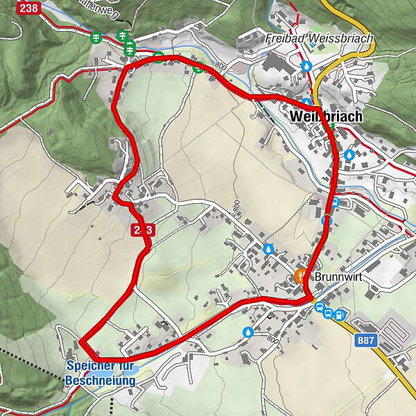
The family-friendly village circuit is accessible in winter and summer and runs through the middle of Weißbriach.
- Difficulty
-
easy
- Rating
-
- Route
-
Waldner's Gasthof Löffele0.2 kmWeißbriach0.3 kmBrunnwirt2.9 km
- Best season
-
AugSepOctNovDecJanFebMarAprMayJunJul
- Description
-
The winter hiking trail "Dorfrundweg" offers everyone the possibility of a leisurely walk around and through Weißbriach. Along the circular path there are several places to stop for refreshments and many places to recharge your batteries.
- Directions
-
From the municipal office in Weißbriach we start along the B87 Weißensee Bundesstraße towards Kreuzberg. After 200 m we turn left opposite the Hotel Löffele onto the Dorfstraße. We follow this road until we reach the district Gritschia - Höhe Kurhotel. Here you have the possibility to continue either via the upper village and the asphalt road, or you turn right onto the field path and cross the "Nadaln" with it. Either way you will reach the catholic church Weißbriach.
Above the catholic church a signposted path on the right leads us to the ski lifts of the Weißbriach cable cars. We cross the lift bridge and follow the road to the left to get back on the main road. Now we only have to walk along the B87 Weißensee Bundesstraße towards Kreuzberg to get back to the municipal office.
- Highest point
- 836 m
- Endpoint
-
Weißbriach Gemeindeamt
- Height profile
-

- Tips
-
Use one of the rest stops along the way.
- Directions
-
From the north (D, NL, DK):
Tauernautobahn - junction Spittal - direction Lienz - Greifenburg - over the Kreuzberg - WeissbriachSalzburg - Badgastein (rail loading - Tauern lock) - Mallnitz - Möll bridge - Greifenburg - over the Kreuzberg - Weissbriach
From the West (CH, F):
Felbertauern - Mittersill - Lienz - Greifenburg - over the Kreuzberg - Weissbriach
From the south (I, SLO):
Udine - departure Hermagor/Gailtal - Hermagor - WeissbriachKarawanken motorway - Villach junction - direction Italy - exit Hermagor/Gailtal - Hermagor - Weissbriach
From the East (SLO, HR):
Klagenfurt - Villach - departure Hermagor/Gailtal - Hermagor - Weissbriach
- Public transportation
-
From Villach the train takes you to Hermagor. From there the bus line 5066 goes to Weißbriach.
By plane
The nearest airport is in Klagenfurt.
Airport transfers are available via Gitschtalreisen Wastian and Mobilbüro Hermagor.
- Parking
-
Parking in front of the municipal office
- Author
-
The tour Dorfrundweg - Weißbriach/Gitschtal is used by outdooractive.com provided.