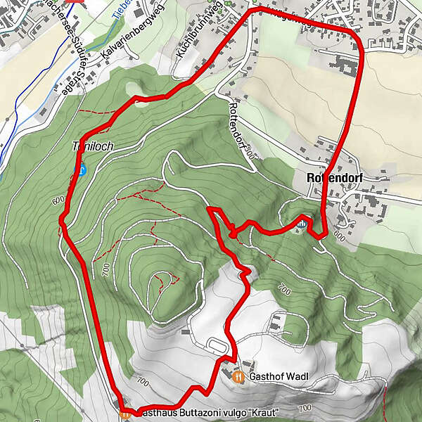
Tour data
4.18km
568
- 734m
154hm
141hm
01:17h
- Brief description
-
Wanderung
- Difficulty
-
medium
- Rating
-
- Starting point
-
Lindl
- Route
-
Unterrain0.1 kmToniloch0.4 kmKuchlbrunn0.4 kmGasthaus Buttazoni vulgo "Kraut"1.2 kmPollenitz1.7 kmKirche Rottendorf "Hl. Wolfgang und Hl. Magdalena"2.7 kmRottendorf2.9 kmLindl3.5 kmFeldkirchen (554 m)3.8 km
- Highest point
- 734 m
- Endpoint
-
Lindl
- Rest/Retreat
-
Jausenstation Buttazoni vlg. Kraut, Tel.Nr.: 04276 8133
Gasthof Wadl, Tel.Nr.: 04276 8132 - Ticket material
-
Feldkirchner Stadtplan erhältlich im Touristikbüro Feldkirchen.
Amthofgasse 3, 9560 Feldkirchen
Tel.Nr: 04276 2176, E-Mail: tourismus@feldkirchen.at
GPS Downloads


Trail conditions
Asphalt
Gravel
Meadow
Forest
Rock
Exposed
Other tours in the regions
-
Wörthersee - Rosental
1956
-
Feldkirchen und Umgebung
939
-
Feldkirchen
199