© MBN Tourismusmanagement GmbH - © NaturAktiv - Franz Gerdl


- Brief description
-
Die "Nocke" entlang spazieren und die allerfeinste Aussicht genießen- bei diesem Rundweg für Jung und Alt bestens möglich.
- Difficulty
-
medium
- Rating
-
- Route
-
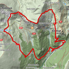
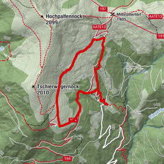
Nock INBrunnachhöhe (1,970 m)1.0 kmMallnock (2,226 m)3.0 kmKlomnock (2,331 m)4.6 kmSteinalmhütte6.2 kmLärchenhütte7.6 km
- Best season
-
JanFebMarAprMayJunJulAugSepOctNovDec
- Highest point
- 2,301 m
- Endpoint
-
Hoferriegel St. Oswald
- Height profile
-


- Author
-
The tour St. Oswald - Rundwanderung - Mallnock - Klomnock | NAT 13 is used by outdooractive.com provided.
GPS Downloads


General info
Refreshment stop
Fauna
A lot of view
Other tours in the regions