
- Brief description
-
AT A GLANCE!
- Altitude: 660 hm
- Distance of route: 12 km
- Ride time: app. 5-6 hours
- Tour difficulty: moderate level
- Difficulty
-
difficult
- Rating
-
- Starting point
-
Tourism information Bad Kleinkirchheim
- Route
-
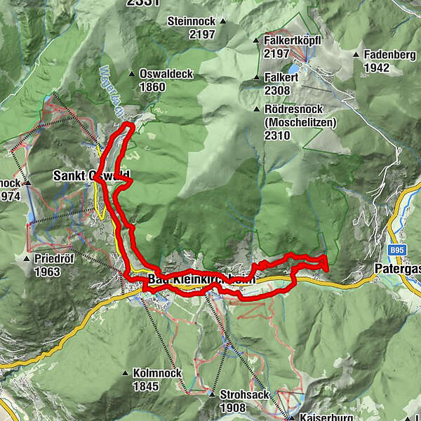
Bach0.0 kmBad Kleinkirchheim1.7 kmZirkitzen2.7 kmRottenstein4.8 kmZirkitzen9.7 kmBad Kleinkirchheim11.0 kmAigen12.2 kmSankt Oswald19.5 kmBach22.6 km
- Best season
-
JanFebMarAprMayJunJulAugSepOctNovDec
- Description
-
This discovery trail takes you from the Tourist Office to the Römerbad thermal spa and then on towards the golf course. The high point of the route is the Alpine valerian sculpture at Måtl Sepp: this is an especially romantic spot in the evening, when the blossom is changing colours. After a short rest, continue to the Weger Stadl barn museum in St. Oswald and from there return on foot or with the free “Berg-Thermen” shuttle bus back to the starting point in Bad Kleinkirchheim.
- Highest point
- 1,411 m
- Endpoint
-
Tourism information Bad Kleinkirchheim
- Height profile
-

- Tips
-
Botany tip: Alpine valerian
Valerian is a delicate plant with surprisingly potent properties. Though small and unassuming, valeriana celtica ssp norica works miracles when it comes to relaxation. For thousands of years, this delicate blossom has been enchanting the senses with its inspiring scent. The artist Hans Pertl created the valerian sculpture in Bad Kleinkirchheim as a monument to the plant.
- Directions
-
Follow signs for Bad Kleinkirchheim and then look for the Maibrunn parking lot. You can start your walk at the Tourist Office in Bad Kleinkirchheim
- Parking
-
Car park Maibrunn


- Author
-
The tour Discover Bad Kleinkirchheim is used by outdooractive.com provided.