
- Difficulty
-
medium
- Rating
-
- Starting point
-
Karlbad/Nockalmstraße
- Route
-
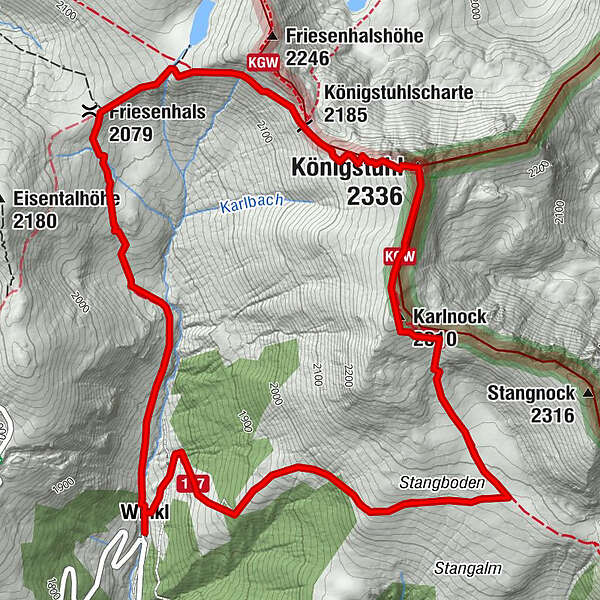
Sarwinkl (1,685 m)KapelleKarlbad (1,693 m)0.0 kmWinkl0.1 kmFriesenhals (2,079 m)2.0 kmKönigstuhlscharte (2,185 m)3.1 kmKönigstuhl (2,336 m)3.8 kmKarlnock (2,310 m)4.5 kmWinkl7.7 kmKarlbad (1,693 m)7.7 kmKapelle7.8 kmSarwinkl (1,685 m)7.8 km
- Best season
-
JanFebMarAprMayJunJulAugSepOctNovDec
- Directions
-
At the Karlbad historic bathhouse, which is located along the Nockalmstraße road, Trail no. 122 passes over a small bridge and continues along the Karlbach brook to Zechnerscharte in the direction of Lake Friesenhalssee. Enjoy walking through a fragrant forest of larch and stone pine, which opens into Alpine meadows after about 20 minutes. In the mornings, there is a good chance of seeing marmots here. The route continues beside idyllic Lake Friesenhalssee along Trail no. 118/125, which leads up to Großer Königsstuhl (2,336 m). From here you can see the “three corners”: the area where the federal states of Carinthia, Salzburg and Styria meet. The route continues on a slight downhill descent with a short ascent back to Karlnock, then down to Stangboden, where Trail no. 117 leads back to Karlbad.
- Highest point
- 2,307 m
- Endpoint
-
Karlbad/Nockalmstraße
- Height profile
-

- Tips
-
Botany Tip - Mountain avens
This relic from the ice age grows mainly on limestone. As its name suggests the flowers of this distant relative of the rose have a ruff of eight delicate petals, which are white and downy on the underside. The plant can grow over 100 years. An infusion made of the leaves -the-so-called "Kaisertee" (emperor's tea) - has calming properties.
-

-
AuthorThe tour Königstuhl circular hike is used by outdooractive.com provided.
GPS Downloads


General info
A lot of view
Other tours in the regions