
- Brief description
-
- Difficulty
-
medium
- Rating
-
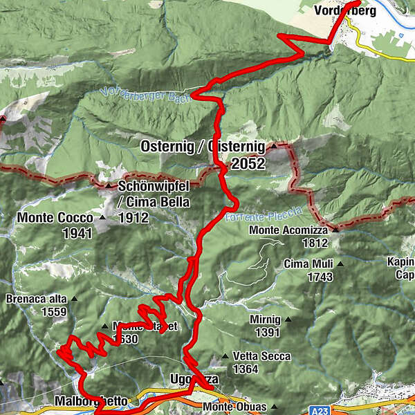
- Route
-
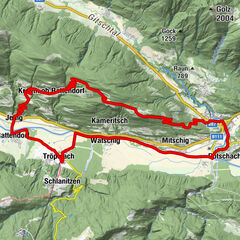
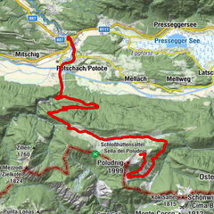
Peter-Paul Kirche0.5 kmOrtsburg Vorderberg0.6 kmVorderberg0.6 kmKoutschitz Alm5.7 kmDolinza Alm (1,499 m)9.9 kmWirtshaus Starhand9.9 kmRifugio Nordio-Deffar10.4 kmRifugio Gortani14.9 kmMalga Prìu17.6 kmFontanella del Rio Rank29.2 kmMalborgeth29.3 kmUggowitz32.4 kmIl Cristo35.1 kmRifugio Nordio-Deffar41.1 kmDolinza Alm (1,499 m)41.5 kmWirtshaus Starhand41.6 kmKoutschitz Alm45.8 kmPeter-Paul Kirche50.8 kmVorderberg50.9 kmOrtsburg Vorderberg51.0 km
- Best season
-
JanFebMarAprMayJunJulAugSepOctNovDec
- Description
-
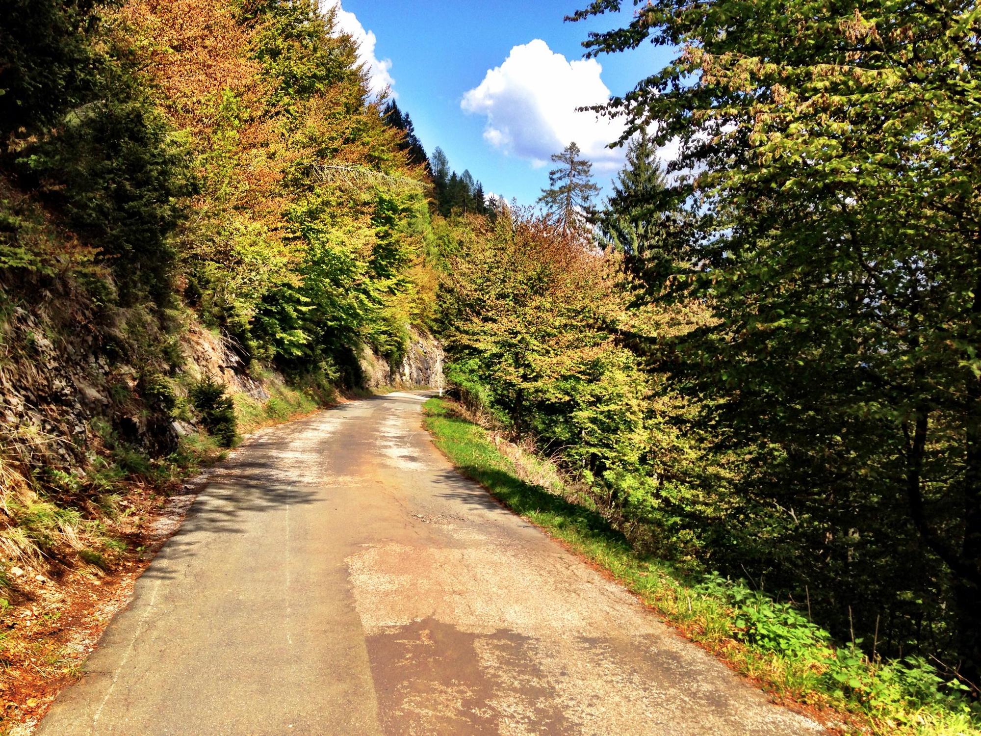
From the Vorderberg adventure natural swimming pool, the trail continues steadily uphill past the Koutschitzalm to the Dolinzaalm. Immediately after the Dolinzaalm you cross the border to Italy and descend towards Ugovizza. At an altitude of about 1,100 metres above sea level, turn right to the Rifugio Gortani, then follow the ascent to Malga Priu. The beautifully situated, rustic alpine hut is a good place to stop for a bite to eat. From here, you go back a small part of the way and then ascend another 230 metres to the highest point of the day. Now follows the long descent to Malborghetto. On the Ciclovia cycle path you then head east to Ugovizza, where the climb back towards Dolinzaalm begins. From the Dolinzaalm you follow the well-known path back to the starting point. Especially the steep ascent to the Dolinzaalm becomes a pure pleasure with the E-MTB.
HIGHLIGHT: just above Malborghetto, at KM 28, you will find a small park that invites you to take an extended break
- Directions
-
KM 0.5 Right over bridge
KM 0.6 after the bridge left
KM 1.4 Turn right towards Koutschitzalm and follow the road uphill
KM 5.7 Koutschitzalm - straight on
KM 6.1 Turn left towards Dolinzaalm - a short stretch of gravel, then a very steep asphalt road up to the alpine pasture.
KM 9.8 Immediately after the Alpengasthof Starhand, turn right across the meadow to the national border
KM 10.0 After the border, bear right (downhill)
KM 10.4 Rifugio Nordio - straight on
KM 12.2 Car park - straight on downhill
KM 13.6 Turn right across the stream and continue uphill for a short distance on a very steep cart track. Carry straight on until you reach another stream crossing - turn left here - the road flattens out again
KM 14.9 Rifugio Gortani - straight on
KM 15.0 Keep left KM 15.2 Turn right - asphalt road slightly uphill
KM 15.5 Turn left onto a gravel road and follow it uphill to Malga Priu
KM 17.0 in the right-hand bend at an altitude of approx. 1,230m above sea level, straight on to Malga Priu
KM 17.5 Malga Priu - back to the bend at 1,230m
KM 18.0 Bend at 1,230 metres - turn left uphill to an altitude of 1,500 metres - stay on the main road
KM 21.1 The descent to Malborghetto begins here - always stay on the main road
KM 28.8 Malborghetto - take the second right
KM 29.2 Turn left and, shortly afterwards, cross the main road
KM 29.4 Turn left and follow the narrow road to the cycle path
KM 30.1 360-degree loop up to the Ciclovia cycle path - follow this to Camporosso
KM 31.9 Turn off the cycle path and enter the town of Ugovizza (left)
KM 32.1 Cross the main road
KM 32.2 Carry straight on and follow the asphalt road into Val di Ugovizza
KM 39 Keep left at the car park - change to gravel road
KM 40.8 Rifugio Nordio - further uphill
KM 41.2 Border with Austria - on to the Dolinzaalm and back to your starting point along the familiar route
- Highest point
- 1,491 m
- Endpoint
-
Erlebnis-Naturbad Vorderberg
- Height profile
-

- Equipment
-
Helmet duty!!!!!!
Right clothing: Do not only adapt your clothing to the current weather conditions.
Also pack warm clothing, a spare jersey and rain protection in summer, especially in the early and late seasons.
Emergency equipment: bandages, repair kit (spare hose, pump, tools), map, mobile phone and possibly GPS
ATTENTION: In the mountains reception is not guaranteed everywhere!
Take enough to drink with you and plan a stopover in good time - Safety instructions
-
When the line is closed - absolute driving ban!
Always drive on half sight.
Always adjust your speed so that you can stop in time before obstacles or avoid oncoming traffic
Watch out for pedestrians and hikers and drive slowly past
Driving on the track with motorcycles will be reported without exception.
The use of the bicycle routes is at your own risk.
In the forest, especially camping, camping in the dark, making fires, disturbing game or entering forest cultures under 3 m tree height are prohibited by law.
Check your sports equipment regularly and wear a helmet
Only the use of the approved, marked routes is permitted.
Never leave the marked path
We ask for consideration for the environment.
Avoid noise and pollution.
Restrict driving in the twilight to protect wild animals.
Observe the road traffic regulations and provide first aid if necessary.
Please always close gates and gates.
Caution during forestry work!
Correct self-assessment
Start in time and plan for reserves
Leave higher altitudes in bad weather
Make sure that you can get through safely if there are impassable stretches of road.
If you do not feel safe, turn back soon enough
For a safe cooperation please follow the Fair Play rules (Link) Emergency call: (+43 4282)112 - Tips
-
In summer, the alpine pasture offers wonderful, regional delicacies - an ideal refreshment!
- Additional information
-
Along the route there are numerous sights such as;
Vorderberg Castle
Church Maria in the ditch
Adventure natural swimming pool Vorderberg
Koutschitz Alm
Dolinzalam
Nordio - Directions
-
From Western Austria and Germany
On the Tauern Autobahn (A10) via the Tauern and Katschberg tunnels (toll) to the Feistritz/Drau exit, continue in the direction of Hermagor over the Windische Höhe, in St. Stefan turn right in the direction of Vorderberg until you reach the Vorderberg adventure natural swimming pool.
Or: alternatively, continue on the A10 to the Villach junction, continue on the A2 Südautobahn in the direction of Italy, exit Hermagor/Gailtal in the direction of Hermagor. Turn off to Feistritz/Gail, direction Vorderberg until you reach the Erlebnis-Naturbad Vorderberg.
Or: Motorway via Rosenheim, Kufstein (A12 Inntal motorway, exit Kufstein Süd), Felbertauern tunnel (toll) to Lienz, Gailbergsattel, Kötschach-Mauthen, direction Hermagor, continue to St. Stefan, turn-off to Vorderberg until you reach the Erlebnis-Naturbad Vorderberg.
From Eastern Austria
Take the southern motorway (A2) to the Hermagor/Gailtal exit. Continue via the Gailtal feeder road in the direction of Hermagor. Turn off to Feistritz/Gail, direction Vorderberg until the Erlebnis-Naturbad Vorderberg.
From Italy
Autostrada Udine - Tarvisio - exit Hermagor/Gailtal. Continue via the Gailtal feeder road in the direction of Hermagor. Turn off to Feistritz/Gail, direction Vorderberg until you reach the Erlebnis-Naturbad Vorderberg
- Parking
-
Public parking spaces are available directly at the starting point.
- Author
-
The tour I1 - Dolinza Alm – Malga Priu Runde is used by outdooractive.com provided.