
- Brief description
-
This tour to the Egger- and Poludnig Alm is considered a regional classic and is a popular destination for both mountain bikers and racing cyclists.
- Difficulty
-
difficult
- Rating
-
- Route
-
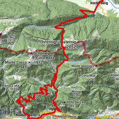
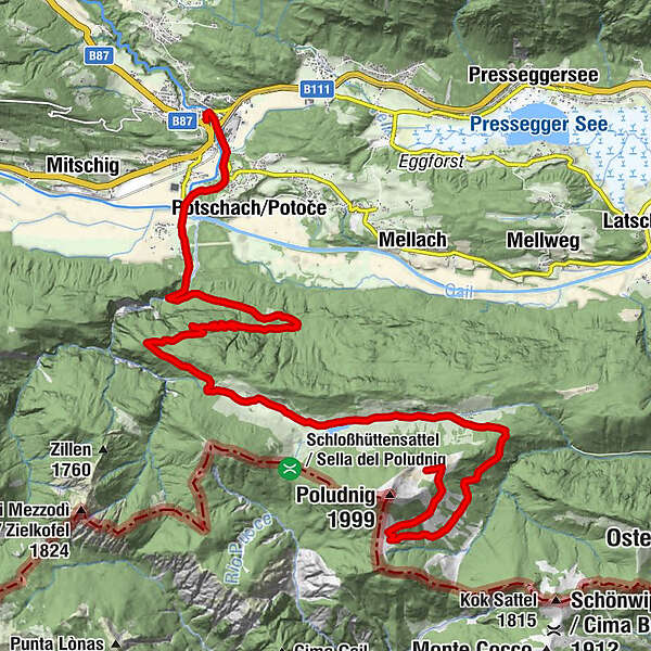
Sant'Ermagora0.0 kmMarienkapelle0.3 kmKühwegboden1.9 kmGail-Wirt2.3 kmMöderndorf2.6 kmKlammwirt3.8 kmKehre 129.2 kmEgger Alm12.6 kmAlmgasthaus "Zur Alten Käserei"12.6 kmRudi`s Skihütte12.6 kmAlmgasthof Poludnig Alm22.3 kmPoludnig Alm22.5 km
- Best season
-
JanFebMarAprMayJunJulAugSepOctNovDec
- Description
-
From Möderndorf the route first heads towards the Garnitzenklamm and then uphill along the Eggeralm Road. From the Egger Alm continue towards the Dellacher Alm - keep right here and follow the gravel road to the Almgasthaus Poludnig. Descent on the same route With the E-MTB this tour is definitely a pleasure.
Variants: Descent via Dellacher Alm - Koutschitzalm and via Vorderberg and the R3 cycle path back to Möderndorf (Tour HP8)
Combination with the following routes: I1
- Directions
-
KM 0 about 100 metres to the north - here you meet the R3B cycle path
KM 0.1 Keep to the right and follow the R3B cycle path to the R3A junction
KM 0.3 Continue right onto R3B
KM 0.5 Roundabout - straight ahead onto R3B
KM 0.8 Straight on - along cycle path R3A to Möderndorf
KM 2.4 straight on - along the R3 cycle path through Möderndorf
KM 3.2 Keep slightly to the right - follow the Eggeralm Road to the Egger Alm
KM 12.7 Egger Alm - along the main asphalt road towards Dellacher Alm
KM 16.1 Turn right towards Poludnig
KM 17.2 From here, follow the gravel road towards the Poludnig Alp
KM 22.5 Poluding alpine pasture
- Highest point
- 1,726 m
- Endpoint
-
Egger und Poludnig Alm
- Height profile
-

- Equipment
-
Helmet duty!!!!!!
Right clothing: Do not only adapt your clothing to the current weather conditions.
Also pack warm clothing, a spare jersey and rain protection in summer, especially in the early and late seasons.
Emergency equipment: bandages, repair kit (spare hose, pump, tools), map, mobile phone and possibly GPS
ATTENTION: In the mountains reception is not guaranteed everywhere!
Take enough to drink with you and plan a stopover in good time - Safety instructions
-
When the line is closed - absolute driving ban!
Always drive on half sight.
Always adjust your speed so that you can stop in time before obstacles or avoid oncoming traffic
Watch out for pedestrians and hikers and drive slowly past
Driving on the track with motorcycles will be reported without exception.
The use of the bicycle routes is at your own risk.
In the forest, especially camping, camping in the dark, making fires, disturbing game or entering forest cultures under 3 m tree height are prohibited by law.
Check your sports equipment regularly and wear a helmet
Only the use of the approved, marked routes is permitted.
Never leave the marked path
We ask for consideration for the environment.
Avoid noise and pollution.
Restrict driving in the twilight to protect wild animals.
Observe the road traffic regulations and provide first aid if necessary.
Please always close gates and gates.
Caution during forestry work!Correct self-assessmentStart in time and plan for reserves
Leave higher altitudes in bad weather
Make sure that you can get through safely if there are impassable stretches of road.
If you do not feel safe, turn back soon enough
For a safe cooperation please follow the Fair Play rules (Link) Emergency call: (+43 4282)112 - Tips
-
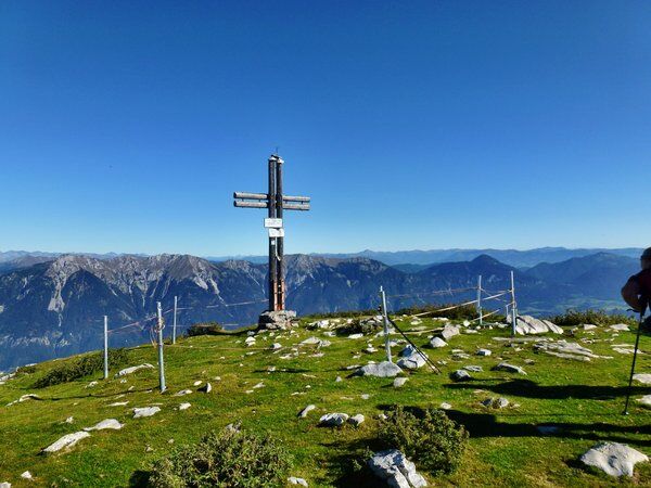
Wonderful view at the Poludnig
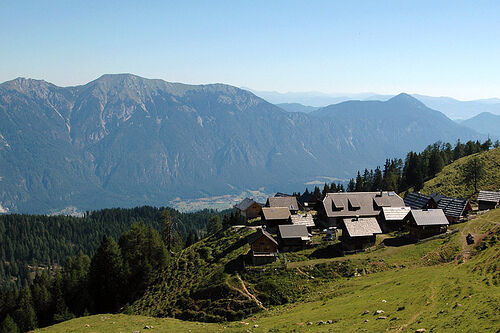
Traditional mountain pastures and local cheese dairy - Additional information
-
Refreshment stop:
Egger Alm:
Gasthof zur Egger Alm / Buachacher Elisabeth Tel.: +43 6503910520
Gasthof zum Rudi Tel.:+43 676 9343605Poludnig Alm
Almausschank / Simschitz Stefan Phone: +43 676 7805317
Dellacher Alm
Almgasthaus / Pipp Johann Tel.: +43 676 9343616
- Directions
-
On the Gailtal road (B111) coming from Kötschach-Mauthen or Arnoldstein to Hermagor. There are numerous parking facilities directly in the city!
- Parking
-
Public parking spaces are available directly at the starting point.

- Author
-
The tour HP2 - Egger Alm - Poludnig is used by outdooractive.com provided.