- Brief description
-
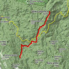
The most interesting phenomenon in this route stage is the group of rocks called Kolovratske stijene, offering a wonderful view towards the sea. The rocks of Kolovratske stijene extend south of the group of Samarske stijene and Bijele stijene, as a solitary ridge on the very edge of Velika Kapela, where the mountain's slopes begin descending towards the sea. The rocky peak area of the ridge of Kolovratske stijene is approximately one kilometer long. Among hikers, Kolovratske stijene are not so well known, since the rocks of Bijele stijene and Samarske stijene are much better known, taller and more beautiful. However, the charm of Kolovratske stijene lies precisely in the fact that they are solitary and close to the sea.
- Difficulty
-
medium
- Rating
-
- Starting point
-
Mountain shelter Zelena kuća
- Route
-
Gorica (1,026 m)11.8 kmAlino bilo (1,106 m)13.7 kmKrivi Put16.0 kmNikolići16.7 kmGornji Veljun19.4 kmVeljun Primorski20.1 km
- Description
-
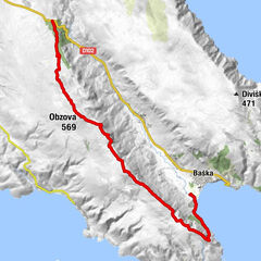
From the Zelena kuća mountain shelter, trail markings first briefly follow the road, and then a steep climb begins to the pass below Kolovratske stijene. On the other side of the pas, the trail steeply descends to the asphalt road. Once there, we can choose between the Kapela – Velebit connecting trail to the left (8 hours of hiking to Vratnik) and the continuation of the markings of the Kapela Hiking Trail to the right, along the road, in the direction of Vinište and Klenovica.
Hiking trail markings along what used to be the connecting trail Kapela – Velebit are no longer maintained, so extra caution is required. However, orientation is not so difficult. In continuation of the route, we need to follow the road direction towards the south and the west, leading to the village of Alan. From that village, the route continues further south along the wider road for 4 kilometers to the village of Krivi Put, where there is a mountain shelter. From Krivi Put onwards, we follow the marked Senj Hiking Tour (Senjska planinarska obilaznica) towards the mountain pass of Vratnik that marks the beginning of the mountain of Velebit.
- Highest point
- 1,084 m
- Endpoint
-
Vratnik
- Height profile
-
 © outdooractive.com


-

-
AuthorThe tour Via Dinarica HR-W-08 Connecting trail Kapela - Velebit is used by outdooractive.com provided.
GPS Downloads


Other tours in the regions
-
Crikvenica
35
-
Senj
7