© Werratal Tourismus Marketing GmbH - Stadt Sontra


- Brief description
-
Schwierigkeitsgrad: leicht
1.500 Höhenmeter
39 % = 24,3 km Asphalt
60 % = 38,1 km Forst- oder Wirtschaftsweg
1 % = 0,6 km Singletrack
Max. 9 % Steigung
- Difficulty
-
medium
- Rating
-
- Route
-
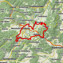
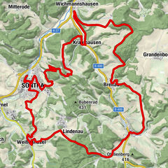
Sontra0.0 kmSontra0.9 kmEv. Kirche6.9 kmStadthosbach7.0 kmMitterode13.3 kmWichmannshausen19.4 kmGrandenborn26.2 kmUlfen31.3 kmMühlberg (467 m)36.3 kmHeßberg (405 m)37.7 kmBlankenbach38.5 kmKrone38.6 kmLindenau51.5 kmWeißenhasel54.9 kmJohanneshof55.2 kmBürgerhaus60.3 kmSontra60.5 kmEv. Kirche Sontra60.6 kmSontra61.4 km
- Best season
-
JanFebMarAprMayJunJulAugSepOctNovDec
- Highest point
- 475 m
- Endpoint
-
Sontra, Bahnhof (Bahnhofsstraße)
- Height profile
-
 © outdooractive.com
- Author
-
The tour MTB-Park Werratal Route 15: Sontraer Runde is used by outdooractive.com provided.
GPS Downloads


General info
Refreshment stop
Cultural/Historical
Other tours in the regions