
- Brief description
-
This winter hike in the skiing area Corviglia leads you to an excellent restaurant with an extraordinary view.
- Difficulty
-
easy
- Rating
-
- Starting point
-
Chantarella
- Route
-
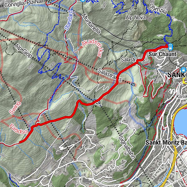
Chantarella0.0 kmSankt Moritz (1,822 m)0.0 kmSur Chaunt0.1 kmSpielplatz Salastrains0.6 kmSalastrains0.6 kmEl Paradiso2.6 km
- Best season
-
AugSepOctNovDecJanFebMarAprMayJunJul
- Description
-
You will take on a few white metres of altitude difference as you walk from Chantarella to Salastrains and through the tunnel under the World Cup runway to the mountain station Signal. From here it is only a stone's throw to "the place to be," the stylishly relaxed Paradiso Mountain Club & Restaurant with its panoramic terrace and alpine lifestyle cuisine.
Note: the hiking trail leads along the ski slope for a while, beware of oncoming skiers.
More information
Engadin Tourismus AG
Via Maistra 1
CH-7500 St. Moritz
Phone: +41 81 830 00 01
E-mail: allegra@engadin.ch
Internet: www.engadin.chwinter hiking trail report: www.engadin.ch/en/slopes-tracks/winter-hiking-trails/
- Directions
-
Chantarella - Salastrains - Signal - Trutz - Paradiso Mountain Club & Restaurant - Trutz - Signal - Salastrains - Chantarella
- Highest point
- 2,181 m
- Endpoint
-
Paradiso Mountain Club & Restaurant
- Height profile
-
 © outdooractive.com

- Author
-
The tour Chantarella - Salastrains - Paradiso is used by outdooractive.com provided.
GPS Downloads
General info
Refreshment stop
A lot of view
Other tours in the regions
-
Veltlin / Valtellina
49
-
Engadin St. Moritz
102
-
Corviglia
53