
- Difficulty
-
medium
- Rating
-
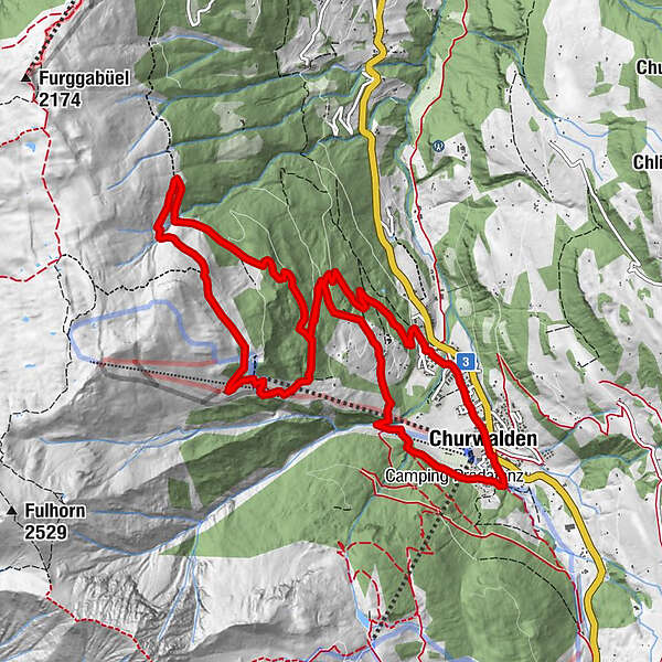
- Starting point
-
Posthaltestelle Churwalden Bergbahnen
- Route
-
Churwalden (1,240 m)0.1 kmBergrestaurant Pradaschier (1,814 m)8.2 kmPradaschier (1,355 m)10.4 kmChurwalden (1,240 m)12.6 km
- Best season
-
JanFebMarAprMayJunJulAugSepOctNovDec
- Description
-
Behind the Churwalden bus terminal, follow the small gravel path through Churwalden to the schoolhouse. The wide forest road leads to Bärenalp. Coming out of the forest, we turn right and follow the single trail at the edge of the forest, which leads to Galtialp. A beautiful high trail continues to Alp Pargitsch and down to the Pradaschier mountain restaurant. A good opportunity for refreshments before we tackle the descent through the village of Pradaschier to Churwalden. An alternative to the descent is the world's longest toboggan run. The fun factor is hard to beat.
- Highest point
- 1,880 m
- Endpoint
-
Posthaltestelle Churwalden Bergbahnen
- Height profile
-
 © outdooractive.com
- Author
-
The tour 742 Pradaschier is used by outdooractive.com provided.
GPS Downloads


General info
Cultural/Historical
Flora
Fauna
A lot of view
Other tours in the regions
-
Heidiland
2208
-
Chur und Rheintal
870
-
Pradaschier / Churwalden
225