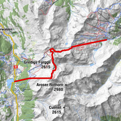
- Route
-
PrätschliRot Tritt2.9 kmPrätschli9.4 km
- Best season
-
JanFebMarAprMayJunJulAugSepOctNovDec
- Description
-
The bus to Prätschli stops at the railway station. Since it provides access to a much-frequented hiking area and bus travel is free in Arosa, get on board early if you want to be sure of a seat. The hiking route is well signposted. First we follow the signpost to Scheidegg, then to Ochsenalp and finally to Rot Tritt and Prätschli. The good signposting allows us to give ourselves over completely to the beauties of nature around us.
At the Prätschli bus stop we turn northwards and follow what is at first a very wide path gradually uphill. Soon we have reached the tree limit. Before we come to the Upper Prätsch Lake (Ober Prätschsee), we turn left onto a narrow path. In varying gradients and always with level stretches for relief, this pathway leads over the ridge called the Scheidegg. In long-drawn-out curves the path now follows the gentle hillside which leads down from the extensions of the Weisshorn. We can look across the Schanfigg northwards out of the valley.
People on the Ochsenalp have a well-kept mountain inn with a lot of good things on offer. Especially to be recommended are the home-made milk drinks. When we leave the Ochsenalp, we have to decide whether to follow the comfortable Alpine road which has little traffic, or the prettily laid out, varied hiking trail to Rot Tritt. We recommend the second alternative. Accordingly, we go back the same way we came as far as the big signpost which shows us the sure way along the shoulder of the mountain. Even before we reach Rot Tritt, we are struck by the panorama of the richly varied, rhythmic form of the mountains of Arosa round about. For a while, we forget about time… Across the pastures and through little bits of woodland we make our way comfortably back to Prätschli.Between the middle of June and the middle of July, this hike is a particularly beautiful one. At that time we pass through a heavenly cornucopia of Alpine flowers. The grazing livestock is for the most part fenced in. In the more arid months of summer, however, the shape of the land is particularly impressive. In the Autumn, we can enjoy the copper colours of the larches and other growing things.
- Directions
-
Arosa Prätschli - Scheidegg - Ochsenalp - Rot Tritt - Prätschli
- Highest point
- 2,095 m
- Height profile
-
 © outdooractive.com
 - Additional information
-
The golden Castle: The “golden castle” is a flowering plant. That was what my mother called the globe flower – and not without reason. Most blossoms open themselves to the sun and the light and lure insects with their scent, colour and brightness, so that they can be pollinated. The globe flower, however, makes a thick ball with its petals. No butterfly, no honey-bee, no bumble-bee can get to its fructifying organs. Only a tiny sort of fly succeeds – attracted by what is for it a heady scent – in getting inside the ball of petals. There golden light awaits it, and with the numerous stamens, a rich supply of food. In dark weather, or when it is cold, or at night-time, the flower gives it a pleasant shelter. Thus because of this the tiny fly stays in its castle and involuntarily fructifies the flower. Only when the globe flower starts to wilt does the little insect leave its host and seek new accommodation.
The unique form of this flower and its golden colouring have resulted in a whole series of picturesque names for it. In the Bernese Alps it is called Ankeballe, in German-speaking Grisons Popperolle (what is meant here are the wavy locks of a blond-haired child).
Globe flowers thrive at an altitude of 700 to 2400 meters. They bloom in June and July. The straight, thin stems grow to a height of between 10 and 70 centimeters. The blossom measures 20 to 40 millimeters in diameter. The almost round petals protect the numerous stamens on the inside. Globe flowers like damp meadows, grassy ridges, high moorland and the banks of streams. They are to be found not only in the Alps but also in the Appenines, the Pyrenees and even as far afield as Norway. In the area through which our hike passes, they cover wide surfaces. This does not mean that masses of them should be plucked, though! This plant has had to be given protected status in several Swiss cantons. - Public transportation
-
Getting there and back: By rail to Arosa, and bus to Prätschli
- Author
-
The tour Arosa Circuit is used by outdooractive.com provided.