- Difficulty
-
easy
- Rating
-
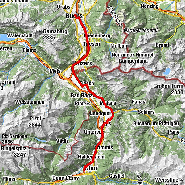
- Starting point
-
Chur
- Route
-
Chur (593 m)1.7 kmMasans3.7 kmRestaurant Bahnhöfli4.2 kmHaldenstein (566 m)4.3 kmSportcenter Fünf Dörfer9.7 kmBöfelihof12.5 kmIgis (563 m)14.3 kmErlahof15.5 kmPagolla18.8 kmGasthaus Krone19.7 kmZum Ochsen19.7 kmMalans (568 m)19.8 kmHotel Weiss Kreuz19.8 kmReformierte Kirche Malans19.9 kmOberdorf19.9 kmJenins (635 m)22.5 kmReformierte Kirche22.7 kmMaienfeld (504 m)24.8 kmFläsch (528 m)27.5 kmTrübbach35.3 kmBuchs (448 m)48.3 km
- Best season
-
JanFebMarAprMayJunJulAugSepOctNovDec
- Description
-
The Bündner Herrschaft, Graubunden’s fertile garden and winery lies on a mound of slate detritus. Also the home of Heidi, Peter and Alpöhi (Heidi’s grandfather).
- Directions
-
Chur - Igis - Maienfeld - Fläsch - Bad Ragaz - Sargans - Buchs
- Highest point
- 631 m
- Endpoint
-
Buchs
- Height profile
-
 © outdooractive.com
- Author
-
The tour 02.03 Rhine Route, Stage 3 Chur - Buchs is used by outdooractive.com provided.
GPS Downloads


General info
Refreshment stop
Cultural/Historical
Other tours in the regions
-
Heidiland
155
-
Bündner Herrschaft
87
-
Maienfeld
34