
- Brief description
-
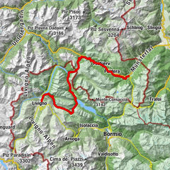
Diese Strecke dient dem OK des NBM als Alternative bei Unwetterschäden sowie Schlechtwetter.
- Difficulty
-
difficult
- Rating
-
- Route
-
San BastianScuol (1,250 m)Fetan (1,648 m)6.1 kmPlazzöl6.7 kmChanoua11.0 kmArdez (1,467 m)12.5 kmSur En15.8 kmKirche Sur En15.9 kmLavin (1,412 m)20.9 kmGüstizia28.3 kmChasuot29.8 kmZernez (1,474 m)32.8 kmBaselgia Brail40.9 kmTegia41.3 kmSur il Chaunt42.7 kmChapella43.7 kmSusauna45.3 kmCurtinellas55.8 kmZernez (1,474 m)76.2 kmReformierte Kirche Zernez77.3 kmChasuot79.4 kmGüstizia81.0 kmCrusch Salet83.2 kmSusch (1,438 m)83.7 kmReformierte Kirche83.9 kmHatecke Ustaria Muzeum Susch83.9 kmLavin (1,412 m)87.9 kmPiz Linard88.0 kmReformierte Kirche88.2 kmReformierte Kirche91.8 kmGuarda (1,653 m)91.8 kmPensiun Val Tuoi92.0 kmCrusch Alba92.0 kmMeisser Dalet92.2 kmBos-cha (1,664 m)93.5 kmGletschermühle94.7 kmArdez (1,467 m)96.0 kmChanoua97.3 kmParadies100.7 kmMuglin (1,600 m)100.9 kmReformierte Kirche101.4 kmFetan (1,648 m)102.0 kmSan Bastian107.7 kmScuol (1,250 m)107.8 km
- Best season
-
JanFebMarAprMayJunJulAugSepOctNovDec
- Highest point
- 2,106 m
- Endpoint
-
Scuol Post
- Height profile
-
 © outdooractive.com
- Author
-
The tour Nationalpark Bike-Marathon Alternativstrecke is used by outdooractive.com provided.
GPS Downloads


Other tours in the regions
-
Engadin Scuol Zernez
208
-
Zernez
38