Tour data
2.17km
1,034 - 1,541m
Distance
-
516hm
Ascent
00:05h
 
Duration
Brief description

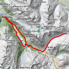
Historischer Weg, lässt Sicht gut als Folge-Etappe mit dem Tail  “Pradel” verbinden.

Difficulty
medium
Rating
Technique
Fitness
Landscape
Experience

Best season
Jan
Feb
Mar
Apr
May
Jun
Jul
Aug
Sep
Oct
Nov
Dec
Highest point
1,541 m
Height profile
© outdooractive.com

Author
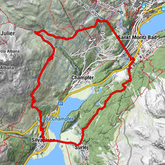
The tour Custin is used by outdooractive.com provided.

Overall rating

5

0

%

4

0

%

3

0

%

2

0

%

1

0

%

Error
An error has occurred. Please try again.
Thank you for your review

Rating has been deleted

GPS Downloads
  • GPX GPS Exchange Format (XML)
  • KML Google Earth, Google Maps
QR Download Codes for Mobile Phones
Other tours in the regions

Popular tours in the area

Pontresina - Val da Fain - Pontresina

medium Mountainbike
29.71km | 609hm | 03:50h

Hahnensee-Trail

difficult Mountainbike
21.17km | 980hm | 03:58h

Signalbahn-Alp Suvretta-Silvaplana-Signalbahn

medium Mountainbike
14.62km | 606hm | 02:30h