© Unbekannt - PNRVN - A.Serylo

- Difficulty
-
medium
- Rating
-
- Route
-
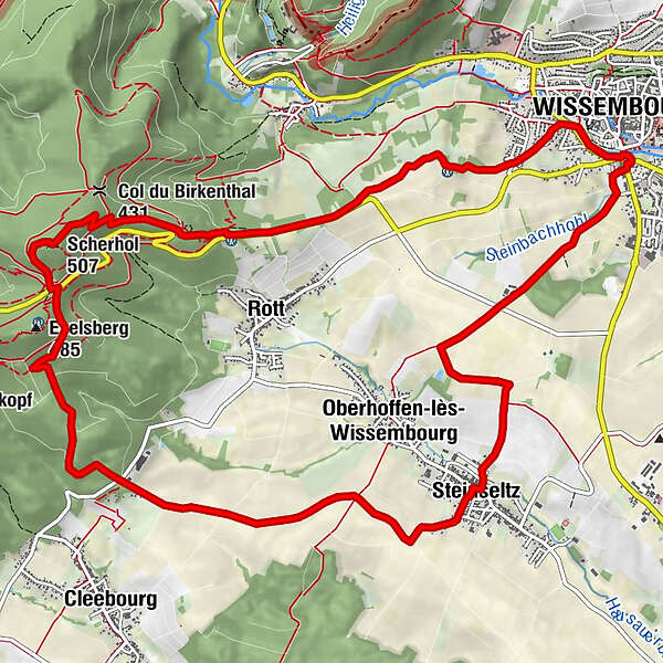
WeißenburgScherhol (492 m)4.9 kmScherhol (507 m)5.2 kmRefuge de Pigeonnier5.7 kmCol du Pigeonnier (432 m)5.8 kmLe Cleebourg7.9 kmIn Sandacker9.2 kmObig der Langwiese10.0 kmIm Geisberg10.3 kmSteinselz11.0 kmIm Hamberg12.7 kmWeißenburg14.8 km
- Best season
-
JanFebMarAprMayJunJulAugSepOctNovDec
- Description
-
A stroll through the Cleebourg vineyard which offers beautiful views!
From the parking lot, head towards the Stichaner Monument.
Follow the red rectangle on the left in the direction of the Col du Pigeonnier, follow the river for 300 m and then turn left into the rue du château d'eau. Turn left again on a track then catch up with the rue de Turkheim, then the rue de la Décapole before turning right onto the track.
After reaching the RD3 departmental road, take the path on the right along the latter, to reach the M.F. Scherhol (altitude 313 m). You are on the Hochwald massif, between the Vosges Massif and the Alsatian foothills. Climb the Edouard Dietenbeck path and continue the ascent towards the pass, still following the red rectangle.
At the junction with the yellow rectangle, follow it to the left (parallel to the red ring) to reach the Col du Pigeonnier and the Club Vosgien refuge (open on the WE).
Cross the RD3 carefully and, at the level of the information portal, enter the operating path marked out with a green disk. Take the path on the left, going down towards the place called Houx Géant, a remarkable tree reaching an exceptional size. Arriving on the RD77, cross it to visit the Cleebourg wine cellar, before continuing on your left. Then, always follow the green disc through the village of Steinseltz, which will take you into Wissembourg via the cemetery. - Highest point
- 498 m
- Height profile
-
 © outdooractive.com

- Author
-
The tour Entre vignes et montagnes is used by outdooractive.com provided.
GPS Downloads


General info
Cultural/Historical
Flora
A lot of view
Other tours in the regions