
- Brief description
-
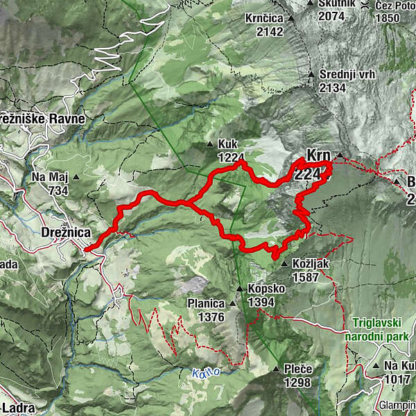
This dynamic and very demanding hiking trail will take you across the attractive areas of the south and southwest slopes of Mt. Krn where you will be able to enjoy in wonderful views along the steep ascent.
- Difficulty
-
difficult
- Rating
-
- Starting point
-
Drežnica
- Route
-
DreschenzSopot0.5 kmGomiščkovo zavetišče na Krnu5.2 kmSopot9.7 kmDreschenz10.2 kmGomiščkovo zavetišče na Krnu18.0 km
- Best season
-
JanFebMarAprMayJunJulAugSepOctNovDec
- Description
-
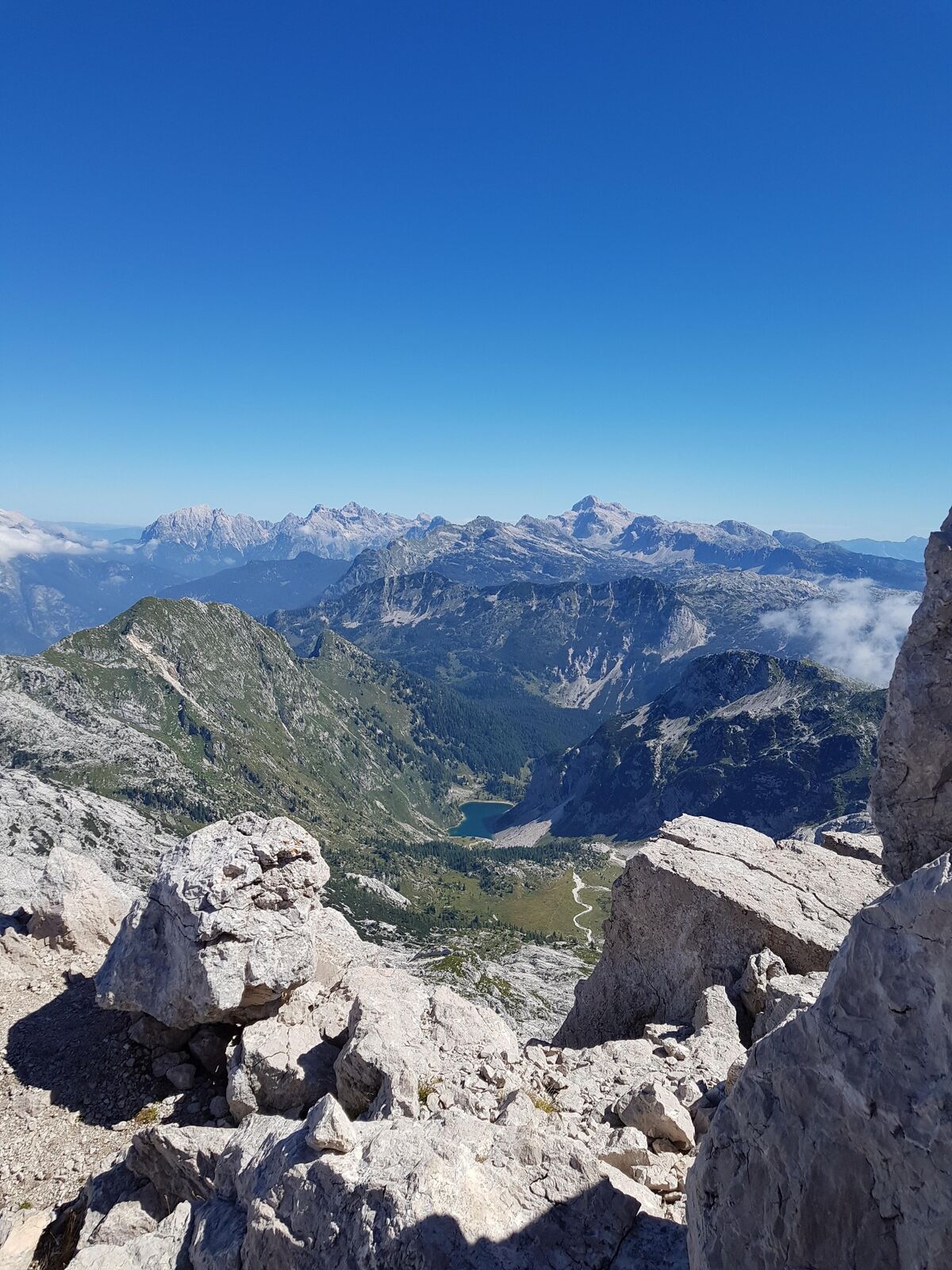
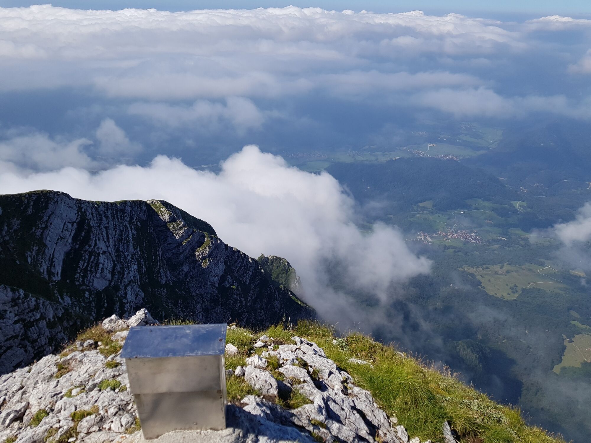
The trail across the area of the village of Drežnica will keep surprising you. It is initially routed across the pastures where Drežnica goats graze and later continues through the forest and along the small creeks all the way to the tree line where the real adventure starts beneath the steep wall rising to the summit of Mt. Krn. Here, you will immediately encounter iron clamps, wire ropes and ladders which will help you climb along a constantly steep and very demanding trail, where you will be able to enjoy in splendid views of the Soča Valley and the surrounding mountains if the weather is fine.
In the Gomiščkovo zavetišče Mountain hut just beneath the top of Mt. Krn, where three hiking trails to Mt. Krn meet, you will be able to refresh yourself with a beverage and a warm meal especially during the summer months. In sunny weather, you will be additionally rewarded on the top with a marvellous view of the Western Julian Alps and of the Soča Valley.
- Directions
-
On the Kobarid bypass, turn for the village of Drežnica, cross the Napoleon Bridge and continue to the left towards Drežnica. In Drežnica, turn to the right and continue to the parking lot next to the elementary school where you will find the starting point of this tour to Mt. Krn. From here, start following the marked trail routed through the forest and across the pastures to the sign of the Triglav National Park where you have to turn left towards the Bivak na Črniku bivouac. When you arrive to the bivouac, turn sharply to the left and continue along the marked trail through the forest. In the following section you will cross the slopes and arrive to the beginning of the extremely demanding secured trail where you will start ascending along the rocky slope with the help of wire ropes and iron clamps. After a couple of sections across secured areas you will arrive to a steep and unsecured section routed across a grassy slope which requires special attention because of a great danger of slipping in wet or dry weather. When you arrive to the junction, turn to the left and continue along the Silvo Koren route. On the right side, this trail is joined with the trail from the Kuhinja Mountain pasture. In the following section, which is steep and exposed but well secured, you will have to climb with the help of wire ropes and two vertical ladders. Later on, the trail gradually ascends and leads to the Gomiščkovo zavetišče Mountain hut on Mt. Krn. From here, you only have to walk for another 10 minutes to reach the top of Mt. Krn. Return to the Gomiščkovo zavetišče Mountain hut along the same trail, turn to the trail towards the Kuhinja Mountain pasture and continue to the junction where you turn to the south trail towards the village of Drežnica. Hike along a sightseeing grassy slope for a while, enter the forest and follow the well-marked trail past the hunting lodge to the junction with a sign of the Triglav national Park. Turn to the left and return to the village of Drežnica.
- Highest point
- 2,141 m
- Endpoint
-
Mt. Krn (2244 m)
- Height profile
-
 © outdooractive.com
 - Equipment
-
It is mandatory to use the helmet, self-belay set and good hiking footwear.
- Safety instructions
-
Grassy and other unsecured sections require special attention due to the slippery and steep terrain. In the late spring season, there is a chance that you will come across sections covered with snow at the foothills of the south wall, which is why we advise you to inform yourself about such issues before taking the trail.
This is a very demanding hiking trail. Use of the hiking trails is at your own risk!
- Tips
-
The Silvo Koren route is appropriate for physically and psychologically well-prepared hikers.
- Additional information
-
We recommend you to take this trail during the summer months.
The Gomiščkovo zavetišče Mountain hut on Mt. Krn is open throughout the summer. We recommend you to inform yourself whether the mountain hut is open before you take the trail.
For more information about the route visit http://www.hribi.net/izlet/dreznica_krn_pot_silva_korena/1/150/1073.
- Directions
-
From Nova Gorica: Nova Gorica - Kanal - Kobarid - Drežnica.
From Ljubljana: Ljubljana - Idrija - Tolmin - Kobarid - Drežnica.
From Bled/Bohinj: Bled - Bohinjska Bistrica - Soriška planina - Podbrdo - Tolmin - Kobarid - Drežnica.
From Bovec: Bovec - Kobarid - Drežnica.
- Public transportation
-
You can reach the village of Most na Soči by train from Ljubljana, Bohinjska Bistrica and Nova Gorica. If you arrive to Most na Soči by train, make sure to coordinate your arrival with the bus schedule from the railway station to the town of Tolmin and from Tolmin towards the town of Kobarid/Bovec, or hire a local transporter.
Train timetable: https://www.slo-zeleznice.si/sl/potniki/vozni-redi.
Bus timetable: https://www.nomago.si/avtobusne-vozovnice/vozni-red.
Local transporters: https://www.soca-valley.com/sl/dolina-soce/kako-do-nas-in-po-okolici/lokalni-prevozniki.
During the summer, there is a Hop On Hop Off shuttle bus running early in the morning from Kobarid to Drežnica.
- Parking
-
Parking is available at the parking lot next to the elementary school in Drežnica.


- Author
-
The tour Along the Silvo Koren route to Mt. Krn (2244 m) is used by outdooractive.com provided.