

- Brief description
-
This stage leaves the Triglav Lakes Valley behind. Although the route avoids the highest of the lakes, it only takes a short detour to visit them, before reaching the hut on Dolič.
- Difficulty
-
medium
- Rating
-
- Starting point
-
Triglav lakes
- Route
-
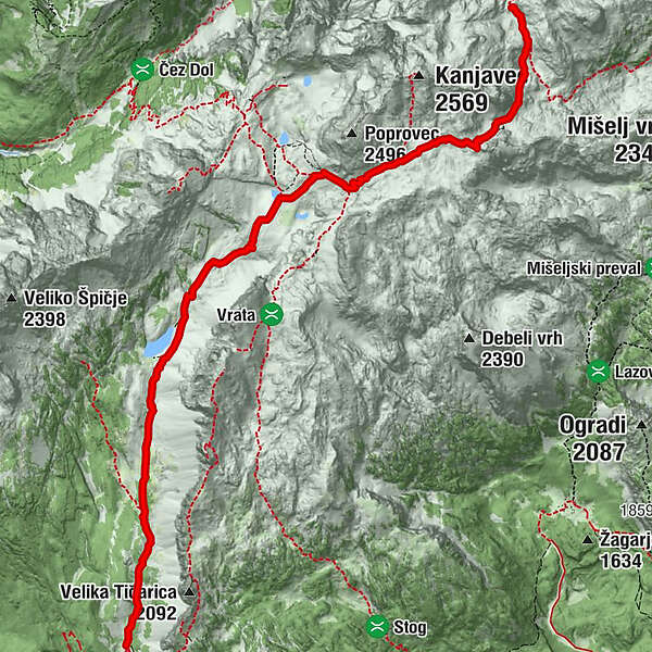
Koča pri Triglavskih jezerih0.0 kmJezero v Ledvicah Viewpoint3.1 kmLake Ledvice High Viewpoint3.6 kmSedlo Dolič (2,164 m)7.5 kmKoča na Doliču7.8 km
- Best season
-
JanFebMarAprMayJunJulAugSepOctNovDec
- Description
-
The 8 km-long Valley of the Triglav Lakes is considered the pearl of the Slovene Julian Alps. It is renowned primarily for the seven mountain lakes which were created because of the Jurassic limestone at the bottom of the valley has a lower permeability. The rocky gravel seals the cracks in the basins holding the lake waters.
The Koča pri Triglavskih jezerih hut (1,685 m) lies north of the Dvojno jezero lake (1,669 m). These are actually two lakes whose waters combine when the water level rises in the spring, and therefore share one name. Veliko jezero (1,830 m), also known as Jezero v Ledvicah, is the largest and deepest of the seven Triglav Lakes. It is 330 m long, 120 m wide and 15 m deep.
Zeleno jezero (1,983 m) is the lowest of the Triglav Lakes with a depth of 3 m. There are two other small lakes in this part of the valley. At Zeleno jezero, a path leads out of the Valley of the Triglav lakes and towards Hribarica na Dolič.
- Directions
-
From the hut, go north up the valley. You will pass the small Močivec lake immediately after the hut, then climb up to the highlands at the foot of Tičarica. The path then levels out and becomes more comfortable, giving you a chance to look around and observe the surroundings, which are rich in Alpine flora and the increasingly rare larch tree. In front of you will be the tall peak Veliko Špičje (2,398 m), which can be reached by way of a path that branches off higher up in the valley. You will arrive at a one-time grazing area known as Pri utah below the bulging rock face of the peak Kopica (2,190 m) to the right above you. 30 minutes.
At the crossroads, continue walking north and upwards through the valley. Grassy patches, larch trees and mountain pine gradually replace the rock. Walk up the gently inclining valley towards the eastern slopes until you see a large body of water in front of you. This is the lake of Veliko jezero (1,831 m), the biggest of the Triglav lakes with a maximum depth of 15 m. It is also known as Ledvička ("Little Kidney") due to its peculiar shape. 30 minutes.
Continue walking along the valley until you cross a conspicuous barrier in the valley, which turns to the northeast here. The terrain here is completely bare and grey but has a small body of water, the lake of Zeleno jezero (Green Lake, 1,988 m). The lake was named after the green algae that grow at its bottom, and is host to Alpine newts and the water buttercup with its white petals. 45 minutes.
The route through the Triglav Lakes Valley ends here. The path to the left leads to Zasavska koča na Prehodavcih (2,071 m). Follow the right path to the right, which gently climbs up to the gravelly glen which falls over the edge of Hribarice. Return to the pass between Poporovec to the left and Vršaki to the right by way of a series of hairpin bends. You will be standing at the edge of the spacious Hribarice plateau where the rocky terrain levels out. The path from Zelnarica will be to the right. Walk east across the plateau, which has sparse vegetation, towards the conspicuous rocky peak of Mišeljski konec. Along the way, a path branches off to the left and leads to Kanjavec. Below Mišeljski konec, you will reach the Čez hribarice pass (2,358 m) which separates it from Kanjavec. You will now be at the highest point. 50 minutes.
Climb up the steep scree slope to the upper reaches of Velska valley. At the crossroads, a path branches off to the right towards Velo polje. Turn left here and follow the gently inclining path until you reach the Dolič pass (2,164 m). Immediately in front of you will be hut Tržaška koča na Doliču (2,151 m) and the end of the stage. 25 minutes.
The hut lies on the Dolič pass between Kanjavec and the Triglav massif. The hike from Koča na Triglavskih jezerih to Tržaška koča na Doliču takes 3h.
- Highest point
- 2,348 m
- Endpoint
-
Tržaška koča na Doliču (hut)
- Height profile
-
 © outdooractive.com
 - Equipment
-
Standard equipment and a camera.
- Safety instructions
-
Swimming or doing other activities in/on the lakes is forbiden, so please restrain yourself.
- Tips
-
Book your stay at huts in advance, as they can be full in the summer.
- Additional information
-
There are seven lakes, the water from the top lake flows into the river Soča, before reaching Jadran see. The other lakes are connected between themselfes, and their water flows into Sava Bohinjka and than to the Black sea.
- Directions
-
Triglav lakes Valley is accessible from different directions, most popular is from Bohinj valley.
- Public transportation
-
This is a mountain stage, so no transport.
- Parking
-
Payable parking in Bohinj

- Author
-
The tour Via Alpina Slovenia: Red trail Stage 11 (Triglav lakes- Dolič) is used by outdooractive.com provided.


General info
-
Region Villach - Faaker See - Ossiacher See
2065
-
Goriška
389
-
Trenta
155


