Via Alpina Slovenia: Red trail Stage 9a (Črna Prst- Rjava Skala)


- Brief description
-
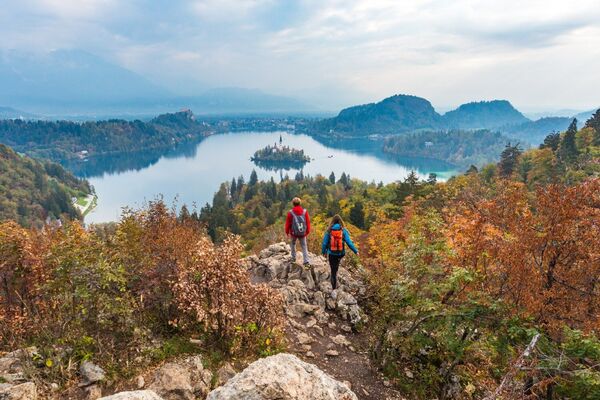
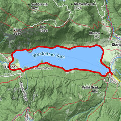
This stage provides magnificent views of the Julian Alps and Lake Bohinj. For its most part it follows the ridge, that connects the Lower Bohinj mountains, making a stop at Vogel.
- Difficulty
-
medium
- Rating
-
- Starting point
-
Črna Prst
- Route
-
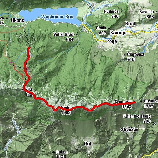
Črna prst (1,844 m)0.0 kmDom Zorka Jelinčiča0.0 kmVrata (1,704 m)0.8 kmKonjski vrh (1,878 m)1.9 kmPoljanski vrh (1,896 m)2.2 kmVeliki Raskovec (1,967 m)3.9 kmNovi vrh (1,942 m)4.8 kmSuha Rodica (1,940 m)5.1 kmRodica (1,963 m)5.8 kmČez Suho Saddle7.7 kmČez Suho (1,771 m)7.8 kmVisoki Orlov rob (1,800 m)9.2 kmOrlove glave (1,682 m)10.6 kmPizzeria Burja12.1 kmPlaninska koča Merjasec12.1 kmRjava skala (1,570 m)12.3 km
- Best season
-
JanFebMarAprMayJunJulAugSepOctNovDec
- Description
-
A ridge links the peaks of Črna prst, Rodica, Vogel and Veliki Bogatin and rises steeply between Baška grapa and Bohinj. This mountain chain is known as the Lower Bohinj Mountains. The most popular of the peaks is Črna prst (1,844 m) because of the abundance of flora there. The wide variety of plants has been drawing botanists for the last two centuries.
The Adriatic Sea can be seen to the south of the Lower Bohinj Mountains whilst Triglav can be seen to the north. Triglav is the tallest mountain in Slovenia, standing out from the other peaks in the Julian Alps. Vogel (1,922 m) is the name of a peak as well as of the Karstic plateau that climbs from an altitude of 575 m to 1,800 m.
To reach the hut, the trail descends from the ridge down the ski slopes (about 1h) to Vogel skri resort. A cableway runs from the Bohinj valley below to the Ski Hotel and ski slopes on the plateau.
- Directions
-
For most of this stage, you will hike west along on the ridge of the Lower Bohinj mountains. At first, you will have to descend down a rather broad ridge, which becomes increasingly narrower. The pleasant part of the walk on the ridge soon comes to an end and you will have to climb up the western part of Črna prst to the Vrata gap (1,721 m).On the other side, climb up the steep and grassy slope below the peak of Četrt (1,832 m), where the narrow track begins levelling out and cuts across the steep, grassy slopes.
The path crosses a ridge and brings you to the pass between the peaks of Poljanski vrh and Matajurski vrh. Continue walking along the ridge. Cross a rocky section then walk along the relatively flat path below the main ridge and past Matajurski vrh to your left. 1h 45 minutes.
At the grassy shoulder, you will cross over into the Primorska region. You will bypass the peak of Raskovec (1,967 m) by way of the southern part of the ridge. You will reach the ridge again after passing through the saddle between Rodica and Veliki Raskovec. Continue walking in the direction of the ridge, moving from one side of the ridge to the other several times. The narrow and steep ridge leads all the way up to the peak of Rodica (1,966 m). 45 minutes.
From Rodica, continue walking along the ridge. Walk down the gentle slope to the foot of Rodica, then up a slight incline to a level ridge. Descend again down the side of the wide meadow to the Čez Suho pass (1,773 m), where you will meet the taril from Ribčev Laz in the valley. There will be another short climb before the descent down the northern face of the ridge to the pass below the conspicuous peak of Šija (1,880 m). 1h 45 minutes.
To the right is Visoki Orlov rob peak (1,800 m), which is accessible by chair lift from the Vogel ski slopes. As the stage is a very long one, this would be a suitable place to take a break. Follow the marked path across Visoki Orlov rob to the Vogel Ski Hotel (45 minutes). This stage will take approximately 5h.
- Highest point
- 1,926 m
- Endpoint
-
Rjava Skala (Vogel)
- Height profile
-
 © outdooractive.com
 - Equipment
-
Rain jacket or windshell highly recomended.
- Safety instructions
-
The ridge is exposed so the stage is not recomended in bad weather conditions. Have enough water and food with you.
- Tips
-
The descend from the ridge to the hut can be shortened, if you are lucky and you can use the ski cableway, when/if operating.
- Additional information
- Directions
-
Head to Bohinj Valley.
- Public transportation
-
You can arrive at Bohinjska Bistrica by car, bus or train and walk about 3h up to Črna Prst, to the start of the stage. Or take the bus to the lower cable station of Vogel, in Ukanc- Bohinj Valley.
- Parking
-
Free parking possible at Bohinjska Bistrica, payable in Bohinj valley.

- Author
-
The tour Via Alpina Slovenia: Red trail Stage 9a (Črna Prst- Rjava Skala) is used by outdooractive.com provided.