


- Brief description
-
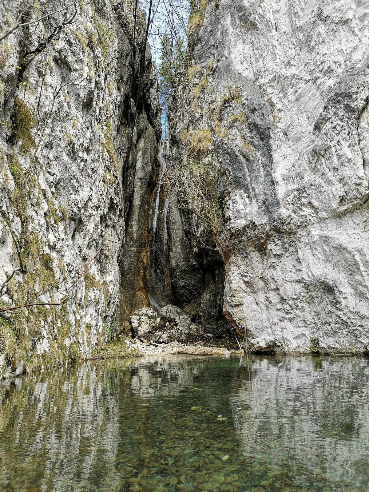
The top of Iglica is accessible to hikers through a narrow crevice, where they can enjoy beautiful views from the peak.
- Difficulty
-
easy
- Rating
-
- Starting point
-
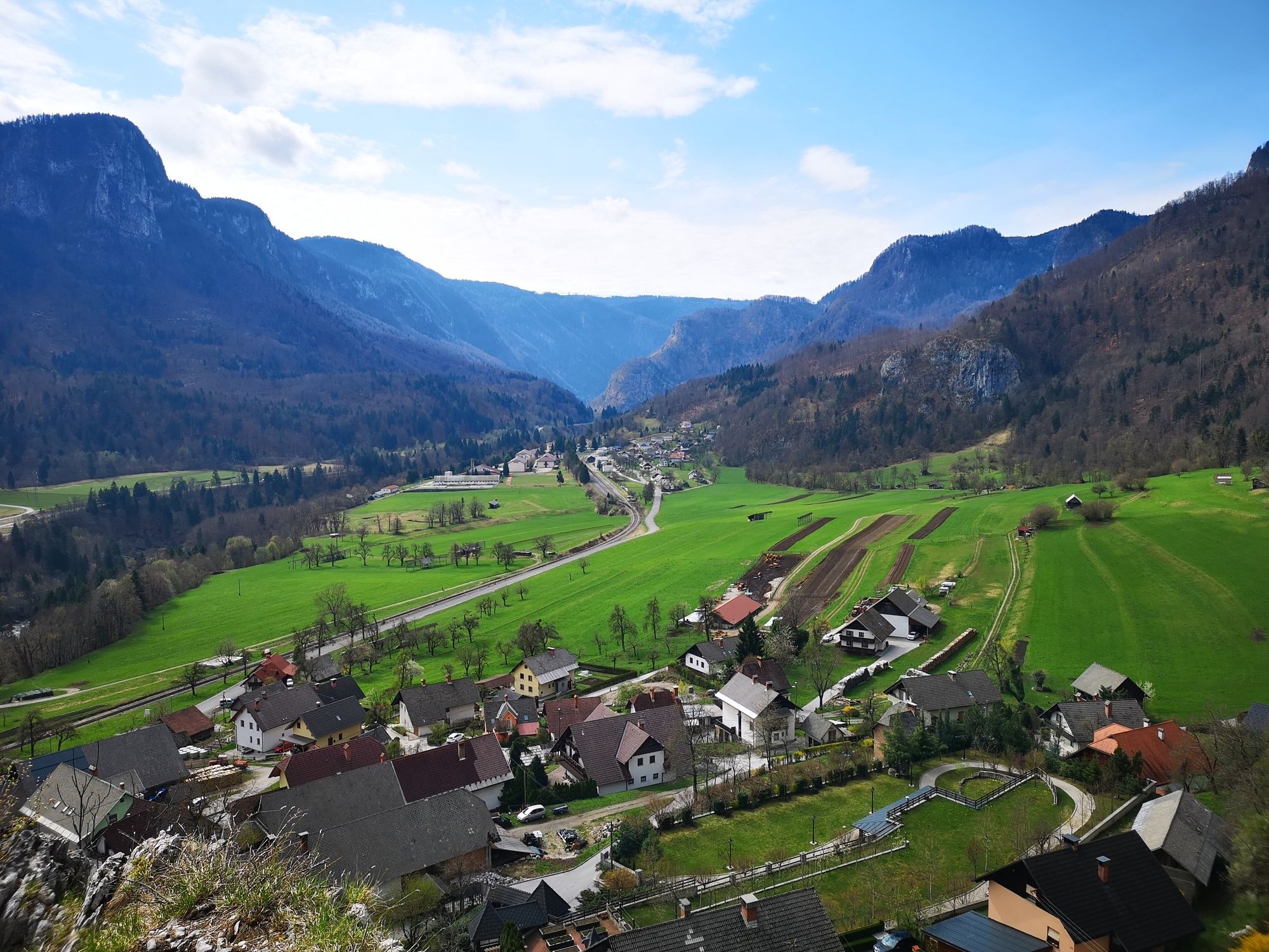
Heart of the village of Bohinjska Bela (488m).
- Route
-
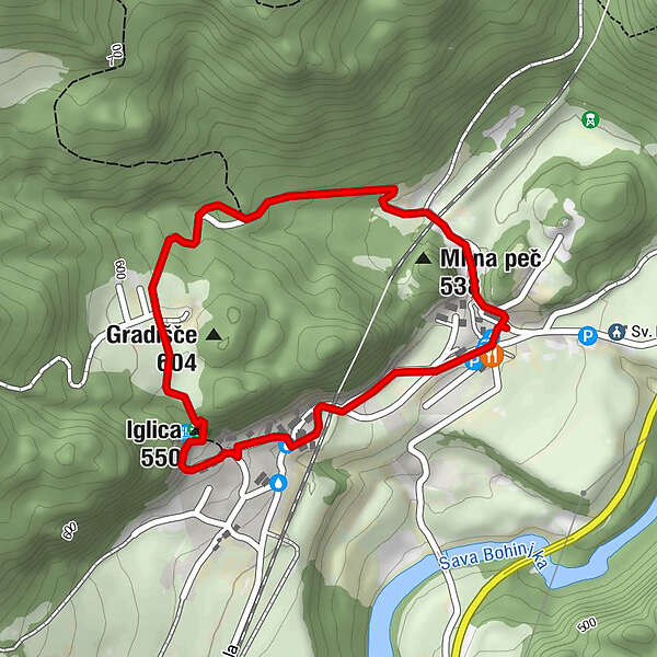
Bohinjska Bela0.6 kmIglica (550 m)0.9 km
- Best season
-
JanFebMarAprMayJunJulAugSepOctNovDec
- Description
-
Besides Babji zob, the rocky walls of Iglica are the most prominent natural sight in Bohinjska Bela. The steep walls are a real paradise for climbers. Many famous Slovenian mountaineers, among them Marjan Manfreda, Tomo Česen and Marjan Zorč, have improved their climbing skills there. The Iglica Waterfall is located amidst the walls. It falls into a small water pool. The small village of Slamniki is right above Iglica; in the past it was known by the name Brezje. There, you can hike further to higher mountain areas or back to the starting point.
- Directions
-
BOHINJSKA BELA – IGLICA – BOHINJSKA BELA
Start in the centre of the village and go left along the pavement; after approximately 50 metres cross the street onto a narrow asphalt road. After 200 metres you will reach a railway underpass. Keep right on the other side and after a short steep hill among the houses continue to the crossroads just before the main road through the village. Turn right to the hill, cross the Suha brook, turn right and continue to the end of the asphalt road. At the last house, turn right onto a stone road and reach the walls and the waterfall. There are metal steps on the right that will lead you to the top. At the top you can enjoy the view of the village, and Babji zob and other mountains. Continue along the path across the meadow to the Brezje settlement, where the fingerpost leads you along the asphalt road back to the village centre. Stay on the asphalt road and turn right before the wayside shrine in the village; from here it’s only a few dozen steps to the village centre.
- Highest point
- 594 m
- Endpoint
-
Heart of the village of Bohinjska Bela (488m).
- Height profile
-
 © outdooractive.com
 - Equipment
-
We recommend hiking shoes and season-appropriate clothing.
The use of sun protection is recommended on sunny days.
In the warmer part of the year the use of tick repellent is recommended.
- Safety instructions
-
The trail is easy and suitable for all types of hikers, except small children.
It is not suitable for baby strollers.
The top of Iglica is spacious, but walking on the edge can be dangerous due to the steep wall.
The trail is marked with fingerposts.
We do not recommend visiting the trail when there is snow and ice. - Tips
-
Don’t forget to take a camera with you. Use the Bled – Hiking Trails or Bohinjska Bela – Hiking Trails maps.
- Additional information
-
TIC INFOCENTER Triglavska roža Bled
Ljubljanska cesta 27, SI – 4260 Bled
E-mail: info@visitbled.si , info.trb@tnp.gov.si
Tel: +386 (0)4 5780 205
Web address: http://www.bled.si ; http://www.tnp.si
TIC - Turistično Društvo Bled
Cesta svobode 10, SI – 4260 Bled
Tel: +386 (0)4 5741 122
Web address: http://www.td-bled.si/
Bohinjska Bela Tourist Association
Bohinjska Bela 37, SI - 4263 Bohinjska Bela
Web address: http://www.bohinjskabela.si/sl/drustva/turisticno-drustvo
- Directions
-
You can drive (4 km by car) or walk (1 hour from Bled town centre) to the starting point.
- Public transportation
-
You can take the bus or travel by train to Bohinjska Bela. There is a regular bus connection operating once an hour from Bled to Bohinjska Bela. The railway station is in the direct vicinity of the finishing point of this trip. For more on how to get to Bled, please visit our website:
http://www.bled.si/en/how-to-get-here
The hike both starts and ends in the heart of the village next to the bus stop in Bohinjska Bela.
- Parking

- Author
-
The tour Over Iglica is used by outdooractive.com provided.


General info
-
Wörthersee - Rosental
1948
-
Bled
209


