From the Koča pri Savici alpine lodge to the Koča pod Bogatinom mountain hut below Bogatin mountain and past Govnjač pasture


- Brief description
-
The trail to Dom na Komni mountain takes you along 66 bends. When reaching the top you can also visit Govnjač and Na Kraju pastures that offer great views of the surrounding peaks above Komna plateau.
- Difficulty
-
difficult
- Rating
-
- Starting point
-
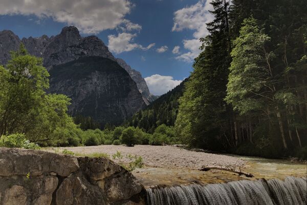
Koča pri Savici alpine lodge (653 m)
- Route
-
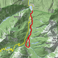
Okrepčevalnica Savica0.1 kmBremza4.4 kmDom na Komni6.6 kmMajerca (1,500 m)10.2 kmBogatin-Hütte10.3 kmBrezno pod lovsko kočo na Komni11.7 kmJama ob poti na Komno (1,303 m)12.7 kmBremza13.5 kmOkrepčevalnica Savica17.8 kmKoča pri Savici17.8 km
- Best season
-
JanFebMarAprMayJunJulAugSepOctNovDec
- Description
-
High mountain pasture Komna stretches above the Bohinj valley. During WWI, this area of Bohinj was part of the hinterland or a transitional area between the hinterland and the Isonzo Front battlefield. Many remains along the trail remind us of this period.
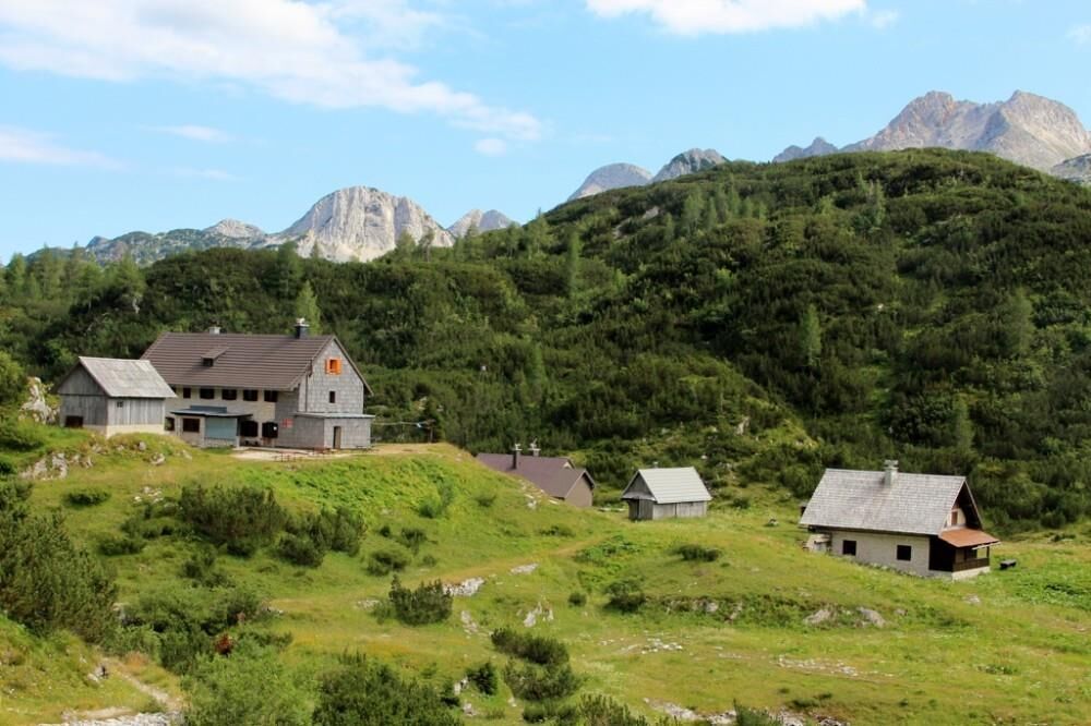
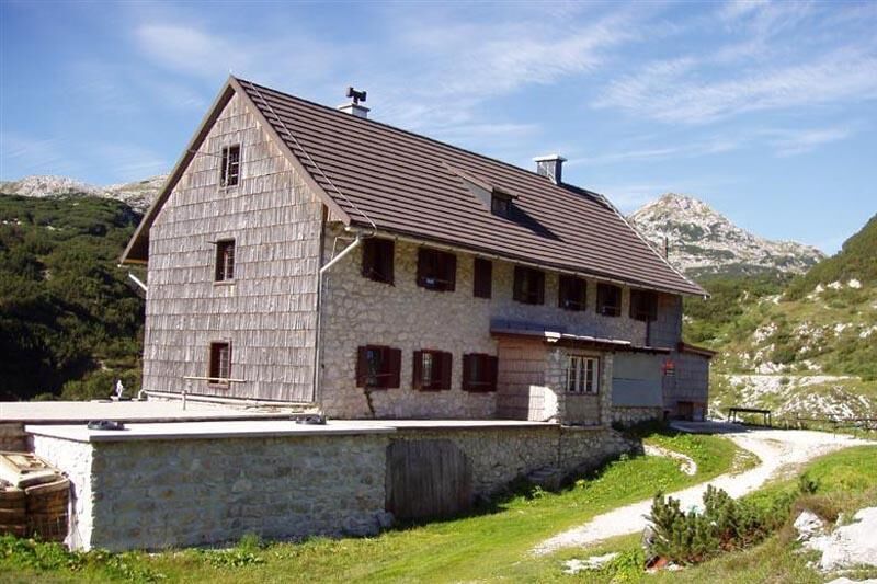
The Dom na Komni mountain hut is open all year round and is located on a panoramic hill west of Lake Bohinj. The hut can be seen from the lake and its surrounding area. There is a panoramic terrace at the hut, which offers a beautiful view of the Bohinj and Tolmin mountain range. The hut is also a starting point for hiking tourist to many Julian Alps mountains.
Govnjač pasture is located on the Spodnja Komna plateau. There are still many architectural remains visible from WWI. On 25 January 2006, the lowest temperature of this area was measured on Govnjač pasture, i.e. -40.2°C.
Koča pod Bogatinom mountain hut is located in the central part of the Na Kraju pasture. It is open in summer season and occasionally during ski touring season. A beautiful view opens up there and stretches to the peaks above Komna plateau.
- Directions
-
From the car park, continue towards the Savica Waterfall and Dom na Komni mountain hut. After a slight ascent, you arrive to a intersection where a tourist path continues right to the Savica Waterfall, and continue left or straight ahead along the wide walking path which used to be a military mule track towards Komna. The trail continues along the Savica brook and then brings you to the first of the marked 48 bends. After one hour ascent through the forest the trail brings you to the 48th bend, where it continues to the right and reaches the so-called “Pekel” (Hell) valley, which ascends slightly and turns right, then the ascent becomes slightly more steep. After 10 steps, the trail turns left and ascends. The ascent is moderate and the trail reaches a small forest from which you can already see Dom na Komni mountain hut. First you come to a small cave and slightly higher to a fenced natural abyss. The trail ascends and after a few steps it brings you to a intersection. To the right, the trail continues to Črno jezero lake. Continue straight on along the wide mule track that brings you to the next intersection. Continue to the left and steeply ascend to Dom na Komni mountain hut.
At the mountain hut you can enjoy in a beautiful view of Lake Bohinj, Rudnica to the east, Pokljuka to the left and Jelovica to the right side of the valley. On the south side, you can see the ridge of the South Bohinj Range that can stretches from Črna prst, Rodica, Šija, Vogel, Vrh nad Škrbino, Podrta gora to Tolminski Kuk and Mahavšček (Veliki Bogatin) and Bogatin, which is on the west side of the hut. Above Lake Bohinj, you can enjoy the view of Rjava skala and Ski hotel on Vogel, Tolminski Kuk and Bogatin, where your eye can stop on the wavy plateau of Spodnja Komna; on the west side, your view stretches across the upper part of Spodnja Komna and Na Kraju pasture to Vratca pass (Bogatinsko sedlo) and Srednji vrh that peaks out from the Lanževice massive. In the north, you can see Lepa Komna and the lower part of the ridge that stretches on the west side of the Triglav Lakes Valley. To the right, you can see Velika and Mala Tičarica and the top of Triglav in the background.
From the mountain hut continue towards Govnjač pasture and Podrta gora long the trail that starts descending steeply. Soon you reach a flat area and after a 5-minute walk from Dom na Komni, you reach a marked intersection and continue to the right towards Govnjač pasture. The trail runs along a former military mule track and mostly descends. After approximately 30-minute walk from Dom na Komni you reach Govnjač pasture where you can see the remains of former buildings.
From Govnjač, follow the marked trail upwards to the west. The trail runs along a wavy karst terrain upwards. Soon you reach the Na Kraju pasture. The last part of the trail steeply descends to Koča pod Bogatinom mountain hut.
The Komna plateau is surrounded with high mountains like an amphitheatre. Thus, the mountain hut provides a beautiful view of the mountains and peaks around the plateau. You can see the edge of the plateau to the east, and the South Bohinj Range to the south. The peaks of Podrta gora, Tolminski Kuk, Mahavšček (Veliki Bogatin) and Bogatin can be viewed. The Vratca pass (Bogatinsko sedlo) is north of Bogatin, and rises above the Gracija valley. Above it you can see Srednji vrh mountain from the Lanževica massive; the view of the northern side is covered by the edge of the Na Kraju pasture, where the trail to the Triglav Lakes Valley runs.
Continue back to Dom na Komni mountain hut and follow the signs for Koča pri Savici alpine lodge to reach the starting point. (Source: www.hribi.net)
- Highest point
- 1,598 m
- Endpoint
-
Koča pri Savici alpine lodge (653 m)
- Height profile
-
 © outdooractive.com
 - Equipment
-
We recommend hiking shoes and clothes as well as enough water. Dom na Komni mountain hut is open all year round, Koča pod Bogatinom is open in summer and in ski touring season.
- Safety instructions
-
There can be fallen trees in some parts of the trail due damage caused by strong winds.
- Tips
-
Prior to every hike, check the weather forecast and trail conditions.
Take some time and visit the Savica Waterfall, one of the most beautiful and popular waterfalls in Slvoenia. You can reach the waterfall from the trailhead at Koča pri Savici alpine lodge in about 20 minutes. This trail offers you many wonderful views of Lake Bohinj, the South Bohinj Range and the west part of Bohinj.
- Additional information
-
Information:
Turizem Bohinj, Stara Fužina, tel.: +386 4 57 47 590
TIC Bohinj, Ribčev Laz, tel.: +386 4 574 60 10
TIC Bohinj, Bohinjska Bistrica, tel.: +386 4 574 76 00
TIC Bohinj, Stara Fužina, tel.: +386 4 572 33 26
TNP Bohinj Centre, Stara Fužina, tel.: +386 1 200 97 60
Julian Alps Card: Bohinj offers free transport and other benefits.
Freshen up at Planinski dom Savica alpine lodge, where you can also enjoy culinary delicacies awarded with the Bohinjsko/From Bohinj certificate. The certificate guarantees the geographical origin of products.
- Directions
-
Drive by car to Koča pri Savici vas from Bled, through Soteska or over Pokljuka. You can also access the village across Jelovica and Soriška planina.
- Public transportation
-
You can travel by train or bus to Bohinj. From the Primorska side, you can also come by car train.
More information is available on the website bohinj.promet.si
In summer, bus rides to Koča pri Savici alpine lodge. Off season, buses ride to Bohinj Ukanc station, where you can start you easy 4-km long hike to Koča pri Savici.
- Parking
-
A car park is available at the starting point (coordinates: 46,2896, 13,8022).
- Author