
- Brief description
-
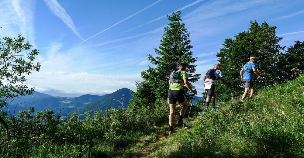
This trail leads along the territory of the municipalities of Bohinj, Cerkno, Tolmin and Železniki. Runners (and hikers) run along mule trails and mountain treks on the slopes of Mt. Črna prst and Mt. Porezen.
- Difficulty
-
difficult
- Rating
-
- Starting point
-
Intersection beneath the Podbrdo Railway station (Kacenpoh)
- Route
-
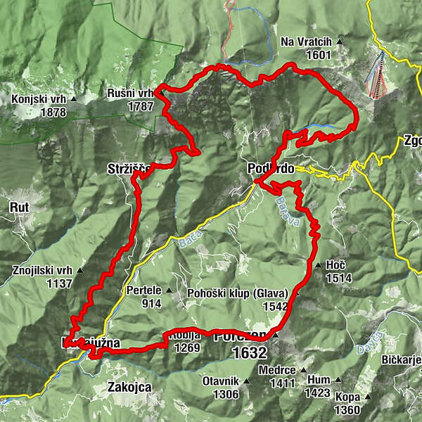
Podberda0.5 kmSv. Miklavž0.6 kmŠance (1,350 m)9.2 kmKobla (1,498 m)10.3 kmPlanina Kal (1,362 m)11.2 kmNa Kalu (1,362 m)11.6 kmČez Suho (1,760 m)13.9 kmBabji zob (1,368 m)15.4 kmKalarsko sedlo (988 m)16.6 kmKal17.8 kmCerkev sv. Ožbolta18.8 kmStržišče19.2 kmKuk21.2 kmZnojile21.8 kmObloke25.4 kmsv. Barbara26.4 kmHudajužna26.5 kmDurnik (1,152 m)30.2 kmRobija (1,269 m)31.0 kmJeseniška planina31.7 kmPorezen (1,632 m)32.8 kmPlaninski dom na Poreznu33.0 kmPohoški kup (Glava) (1,542 m)33.9 kmPodberda39.5 km
- Best season
-
JanFebMarAprMayJunJulAugSepOctNovDec
- Description
-
This marathon route of the four municipalities is organized annually by TD Podbrdo in cooperation with its partners. To some degree, this trail is routed around the upper part of the Baška grapa Valley - from the town of Podbrdo it ascends along the slopes of the Soriška planina Mountain pass in the east, crosses Mt. Kobla and continues to Mt. Črna prst in the north, descends to the village of Hudajužna in the west, and ascends steeply to Mt. Porezen towering above the valley on the south side. This all-day tour requires extremely good physical condition and endurance. It can also be divided into two parts: from the town of Podbrdo to the village of Hudajužna across Mt. Črna prst in the north and from the village of Hudajužna to the town of Podbrdo via Mt. Porezen on the south side. This anti-clockwise route is also the route of the annual mountain-running event, however, the hikers can do it in the opposite direction as well.
- Directions
-
This route runs through the territory of four municipalities: Bohinj, Cerkno, Tolmin and Železniki. The competitors (and hikers) follow mule trails and mountain treks across the slopes of Mt. Črna prst and Mt. Porezen. The trail starts in the very center of the town of Podbrdo (altitude: 521 m). The new part of the route runs along the old road Podbrdo - Petrovo Brdo to the turn towards the Hoba Farm. At the bend beneath the house, the trail continues along the well-routed military mule trail beneath the peak called Kup. The first three kilometers of the route ascend to the Hoba Farm. Behind this farm, the route joins the trail to Mt. Kovce (altitude: 1230 m). From here, the route continues across the Vrh Bače Mountain pass (altitude: 1270 m) to Mt. Kobla (altitude: 1498 m). From Mt. Kobla the trail descends to the Kal Mountain pasture (altitude: 1362 m), and from there it ascends to the Čez Suho Mountain pass (altitude: 1760 m) just beneath the summit of Mt. Črna prst where the marathon reaches its highest point. The trail then runs along the longest marked descent (altitude difference: 950 m) across the Kalarsko Brdo Mountain pass (altitude: 985 m) to the village of Kal (altitude: 817 m). From here, it continues along the asphalt road to the village of Stržišče where, just behind the snack bar, you start descending across the meadows to the footpath towards the village of Znojile (there is 1 km of paved road before you reach the village). After approximately three kilometers of undemanding foothpath, the route reaches the village of Obloke (altitude: 620 m). From here, it descends to the village of Hudajužna (altitude: 361 m) where it reaches the lowest point of the marathon and continues along a long and demanding ascent (6,5 km; altitude difference: 1230 m) across the sections called Žetlc, Rovt, Durnik, Robija and Prehod to the hut beneath the summit of Mt. Porezen. From Mt. Porezen (altitude: 1636 m), the trail descends along the Slovenian Alpine Trail across Trtniška planina, passes the Robar Farm, and descends to the finish line in the town of Podbrdo.
- Highest point
- 1,746 m
- Endpoint
-
Podbrdo Sports field
- Height profile
-
 © outdooractive.com
 - Equipment
-
Good trekking shoes, windbreaker, hiking poles (recommended).
- Safety instructions
-
During the spring months, you might come accross snow patches at higher sections of the route. The route is safe if you stay on the well-arranged trail because it is regularly maintained by the organizers of the running festival.
- Tips
-
Hikers should be physically fit and bring plenty of water and light snacks. In the early spring months, it is worth checking whether the trail is entirely passable and that there are no snowy patches or broken trees along the trail.
- Additional information
-
Turistično društvo Podbrdo
Podbrdo 73A
5243 Podbrdo
T.: +386 41 837 551
- Directions
-
From Nova Gorica: take the 103 to the town of Tolmin and continue along 102 to the village of Bača pri Modreju where you turn left on 403 towards the town of Podbrdo.
From Ljubljana: 211 towards the city of Kranj. After the town of Medvode turn on 210 to the town of Škofja Loka and then on 403 towards the town of Podbrdo (via Železniki).
From Bled/Bohinj: From the town of Bled take the 209 to the town of Bohinjska Bistrica, continue on 909 across the Soriška planina MOuntain pass to the village of Petrovo Brdo where you turn on 403 to the town of Podbrdo.
From Bovec: Take 203 to the town of Kobarid and continue on 102 through the town of Tolmin to the village of Bača pri Modreju where you turn left on 403 towards the town of Podbrdo.
- Public transportation
-
TRAIN: Daily train connection from Ljubljana, Bohinj, Most na Soči or Nova Gorica. The trail starts just 400 m beneath the train station.
Timetable: http://www.slo-zeleznice.si/en/
BUS: Bus from/to Tolmin - available only on school days.
Timetable: https://www.avrigo.si/potniski_prevozi_eng/linijski_promet_eng/vozni_red_eng/
- Parking
-
Free parking is available at the Podbrdo Train station, just 400 m from the starting point.

- Author
-
The tour Julian Alps: Podbrdo Trail Running Festival Marathon is used by outdooractive.com provided.