


- Brief description
-
Fascinating circular trail from the streets of medieval Radovljica to the ruins of Lipnica castle (Pusti grad) uncovering stunning natural and cultural sights along the way.
- Difficulty
-
medium
- Rating
-
- Starting point
-
Main bus station in Radovljica or. Tourist information centre in Radovljica
- Route
-
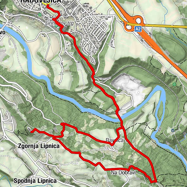
RadmannsdorfGostilna Lectar0.5 kmKamna Gorica3.3 kmZgornja Lipnica5.4 kmRavnica7.0 kmGostilna Lectar9.3 kmRadmannsdorf9.3 km
- Best season
-
JanFebMarAprMayJunJulAugSepOctNovDec
- Description
-
It is not so often that trails of exceptional natural beauty would have their trailhead right in the town centre. The Lipnica castle trail does. Rright outside the former town gates, the path descends into the green carpet of forests down to river Sava. Crossing the mighty Fux footbridge, one enters a most pleasant landscape of forests and meadows surrounding the village of Ravnica.
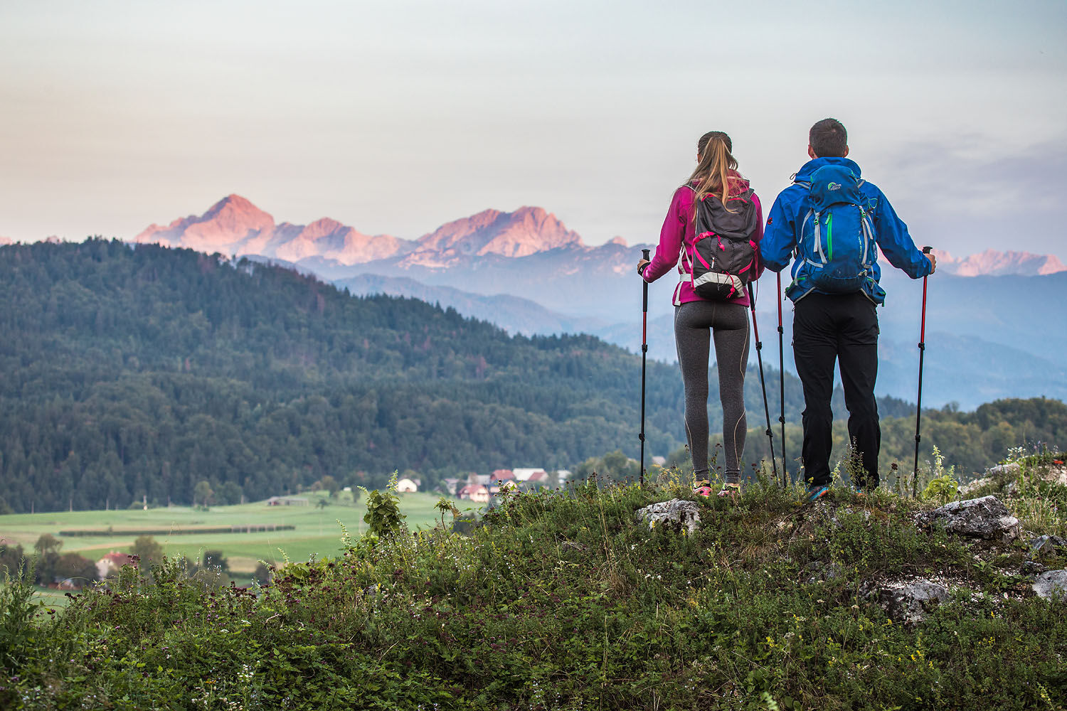
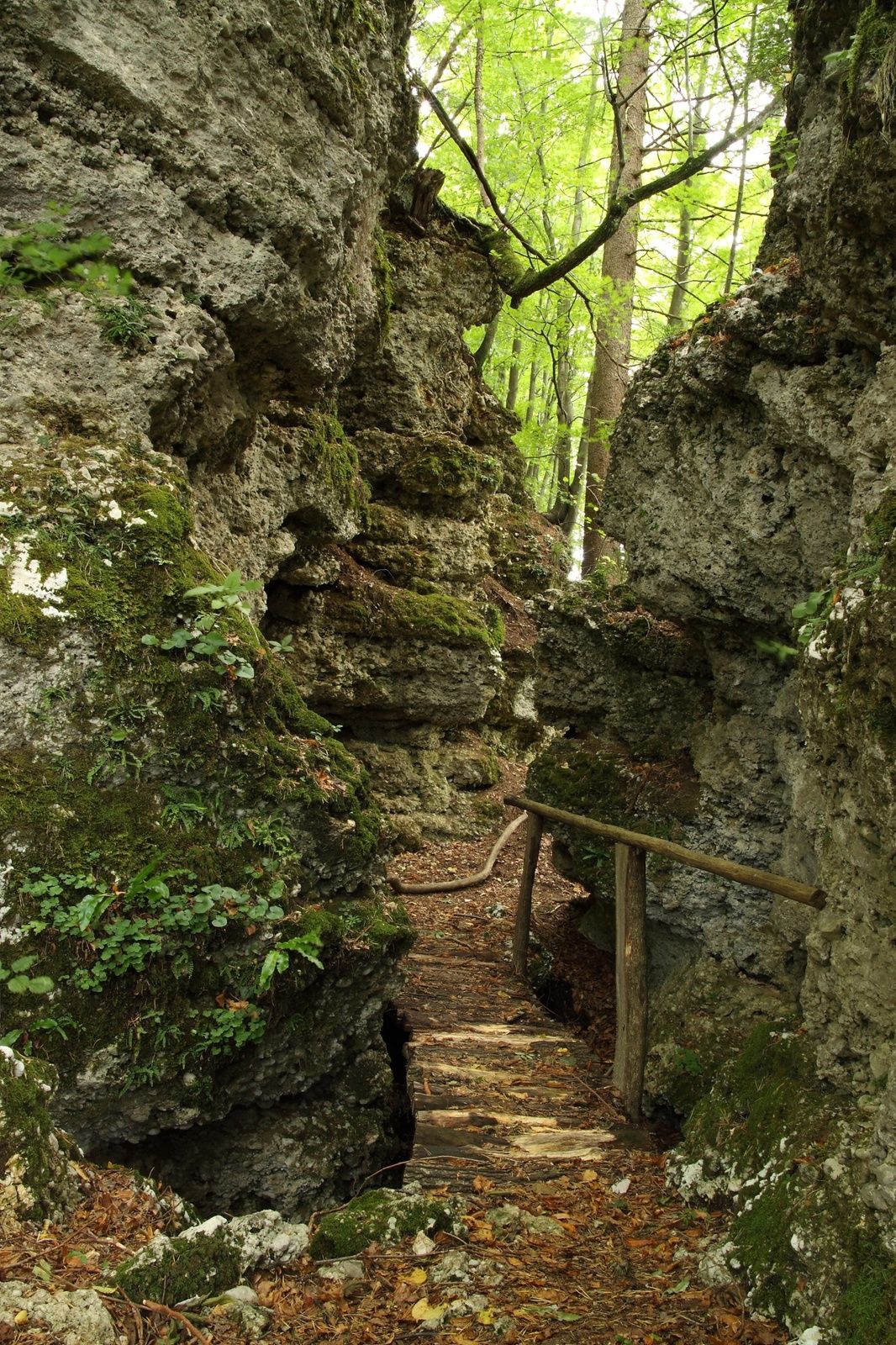
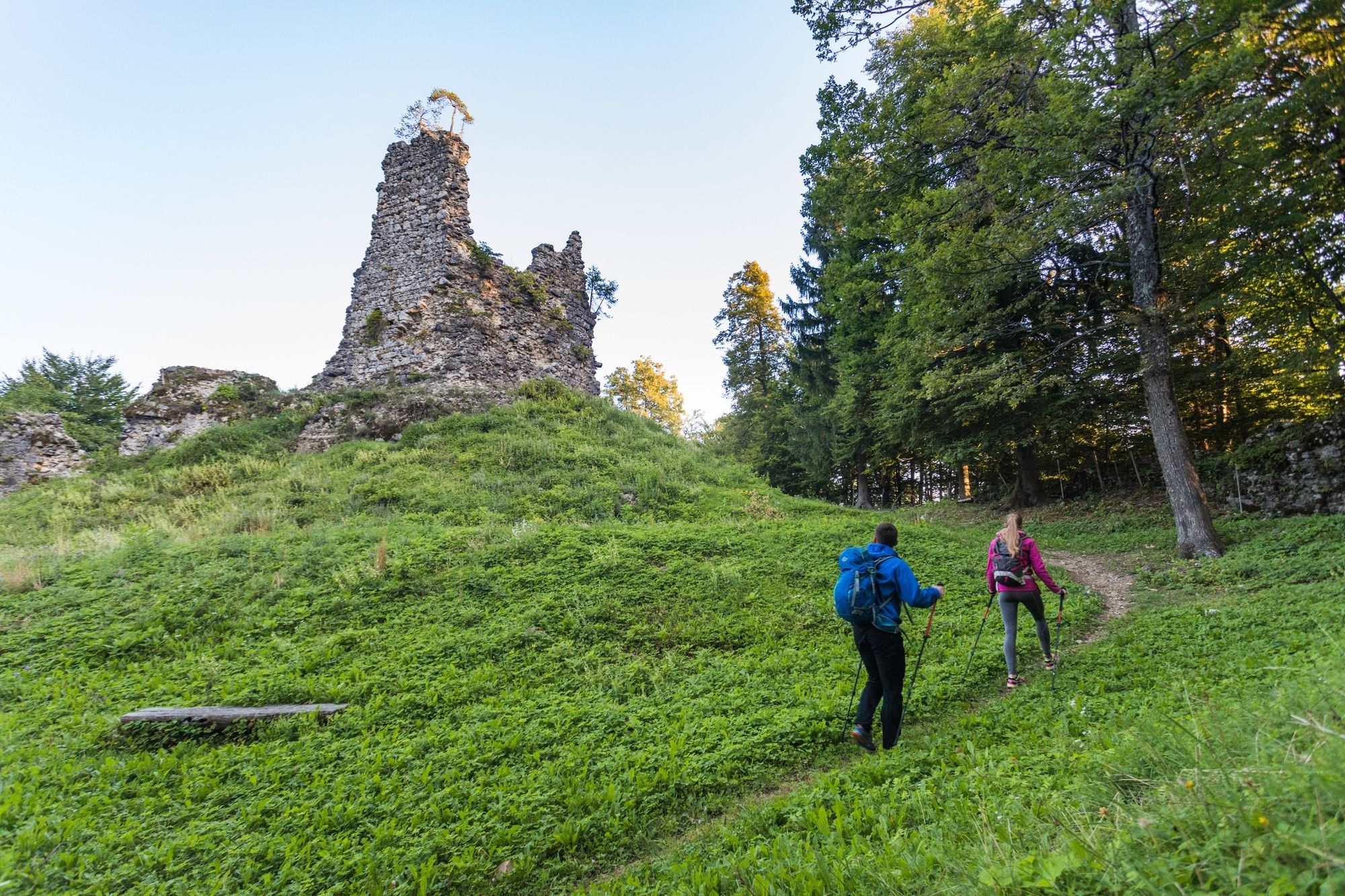
The path leads further through the narrow rocky ravine "Galerije" (Galleries). Wonderful creation of mother nature: embraced with conglomerate cliffs on one side - and giant boulders on the other. Reaching the top of the ridge, the terrain levels and one finds himself amidst the quiet meadows and isolated villages of Lipnica. The scenic ruins of the count Ortenburgs castle is towering on the highest point of the ridge, featuring a delightful view of Julian Alps with their patriarch Mt. Triglav.
- Directions
-
The Lipnica castle trail, with it's original slovenian title "Naravoslovna učna pot Pusti grad" starts right opposite the main bus station in Radovljica. You fill find a large informational panel (with a map of the entire trail) on the meadow between a parking space and a row of shops and bars. Descend down a narrow road (passing by a health food store/pharmacy) to meet a quiet gravel track following an old stone wall (part of former castle park in Radovljica). Soon you will reach a group of houses, one of which is a birth place of a famous slovenian architect Ivan Vurnik. Walk straight trough the yard to meet a junction with an inclined paved road. You will se the town walls of medieval Radovljica on your right and a tunnel-like hole at the foot of the wall. Walk right into it - since this is a former 16th century town moat, one of the landmarks of this town. Walk straight through the moat, until reaching a steep road a the other end. Climb up the steps alongside the road and you will find yourself at a small square just outside the medieval town of Radovljica.
Walk straight into the town (passing by Tourist information centre) to reach the charming Linhart square in the hearth of the old town. After admiring the colorfull facades and frescoes of the prominent town buildings (it's well worth to step inside the mansion too), walk toward the end of the square and turn right into a narrow street. Suddenly you are surprised by an delightfull view of the Sava river valley and the mountain scenery in the background.
Turn left and walk down the descending road towards a railway overpass. Just before the start of the overpass, you will find steps (made of railway sleepers) descending down on your left (signpost: Fuxova brv). Reaching the bottom of the stairs, walk up to the last house in Štrukljeva ulica street. Ignore the road ascending upwards and walk pass the house. The road turns into a narrow cart track and gradually aproaches the railway tracks. Meadows soon close as the trail enters the forest. Within a few minutes of walking you meet a quiet paved road. Turn right on the road and walk trough a short tunnel (railway underpass). You will encounter a small parking space with another information panel featuring a map of the trail (alternative start of the walk).
The path branches off the tarmac road and leads you on the gravel forest road to the forest on right hand side. Ignore the trail ascending to the small terrace and follow the wider road leading downwards and alongside the principal road. Keep left while walking through the forest, reaching a forest clearing with an electric power line. Continue straight ahead to a paintball course and walk along the fence to reach the edge of a natural terrace (zip-line infrastructure on your left). Descend down the steep narrow trail to reach a large gravel parking area of TinaRaft rafting centre.
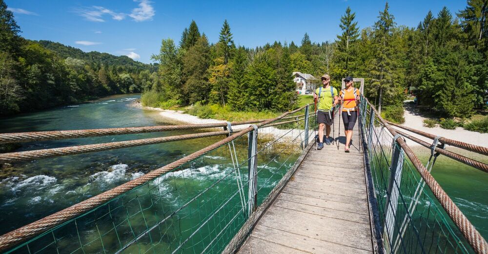
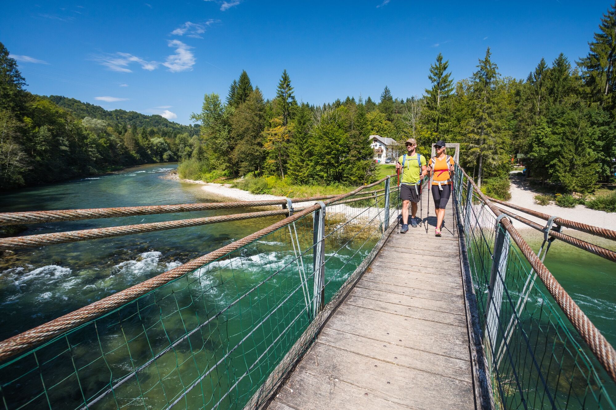
Walk across the parking area to a large footbridge (Fuxova brv), but don't hurry across the bridge just yet. Take some time to stop on the pebble beach by the Sava river, breathe in the atmosphere, throw a stone in the river or cool your feet in the cold mountain stream.
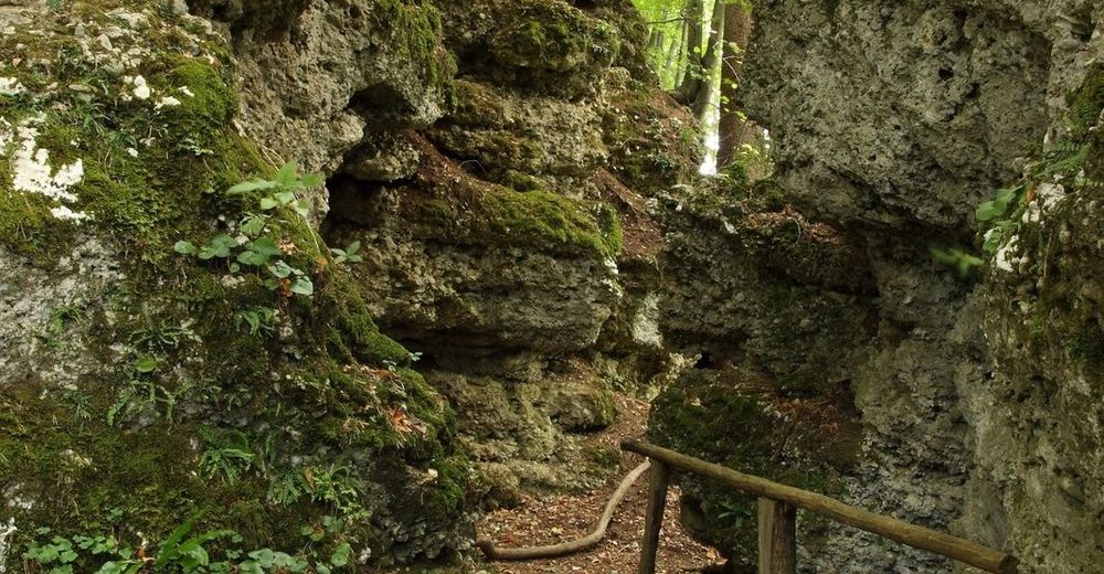
After having made acquaintances with the Sava river, walk across the bridge to the other side. The path ascends in short switchbacks to the first river terrace (information panel presenting geology of the area, start of zip-line). Reaching the first fork, turn left (signs for Kamna Gorica, Pusti grad). Soon you will reach another fork, where you continue straight ahead. Ascending up the forest you will meet large conglomerate boulders, one featuring a shrine dedicated to Mother Mary. Continue walking upwards on the trail, until reaching a small rest area (benches on your right-hand side) and an information panel on presenting wildlife of the area. Turn right (signs for Galerije and Pusti grad) to reach the fascinating narrow rocky ravine called Galerije. The path on narrow wooden bridges at the foot of the giant cliffs in very rewarding and definitely counts as one of the highlights of this walk. At the end of the ravine a narrow trail zig-zags to the top of ridge to reach a view point known as Mil pogled (could be translated as "pleasant view").
However, if such environment is by any chance not to you liking, you can choose a detour: hike on the cart track to the top of the ridge, than follow a forest road leading to your right-hand side to reach Mil pogled viewpoint.) If you are planing on visiting Kamna Gorica do not turn right here, but continue straight on untill you reach the shrine and turn right at the shrine.
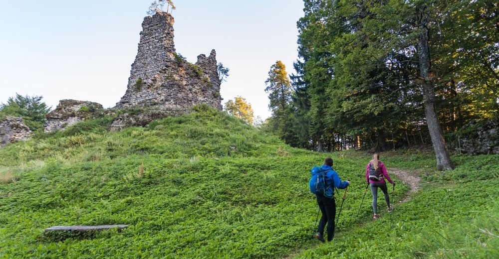
When you reach the upper terrace, turn right. The terrain levels and the walk continues amidst the quiet meadows and isolated villages of Lipnica. Walk passed the farm on your left and continue straight ahead ignoring the road coming from your left. Turn right in the first junction (signs Pusti grad). Walking across wide open meadow you will reach a second junction very fast. Turn left to meet another junction (group of fruit trees, a WWII memorial stone). Turn right. Ignore the cart track leading to the meadow on your left and follow the principal road to yet another junction. Walk straight ahead (ignore the road descending down on the right hand side) to reach a quiet village. Walk straight through the village (don't be afraid of the loos dog, he is very friendly). Towards the end of the village - before the road starts to descend steeply to a saw mill - you will meet another junction. Turn right and start ascending up a narrow road leading up the ridge. Soon you will reach an isolated farm where tarmac turns into a gravel road. Walk pass the farm towards the forested top of the hill. Just before the top the road levels and you can recognize a former dry castle moat on your left-hand side. Turn left, walk through the moat to reach the steps leading up to the doors in the outher walls of Lipnica castle. Climb up (make sure you close the fence - sheep grazing area) and explore the castle ruins and the stunning views from the terrace beneath the central romanesque tower.
Hiking back to Radovljica, return to the steep road that lead you to the castle and retrace your steps down to the first house in the village (no. 6, private motorcycle collection).Though it might seem unussual, walk across the private yard and head to the edge of natural terrace. You will notice a cart track descending down alongside an orchard on the right-hand side. Walk down the cart track that leads you towards an partly owergrown forest meadow. The trail soon bends to the left and meets a paved local road. Turn right when reaching the road. Follow the road which soon brings you to the meadows on the edge of the small village Ravnica.
Reaching the junction in the centre of the village, turn left and walk straight ahead on the narrow cart track to the edge of the natural terrace. The cart track splits in a fork, choose the left one which leads you down to river Sava in a small loop. Soon you will reach the familiar trail and Fux footbridge. Walk across the bridge and retrace your steps back to the trailhead.
- Highest point
- 565 m
- Endpoint
-
Main bus station in Radovljica or. Tourist information centre in Radovljica
- Height profile
-
 © outdooractive.com
 - Equipment
-
As there are no bars and restaurants along the way, make sure you pack enough water or a small snack.
- Safety instructions
-
In wet and slippery weather avoid the Galerije ravine and take the detour on the trail ascending on the left hand side of the cliff and following a gravel road leading to the top of the ridge. On top of the ridge turn right and follow the path through the forest.
- Tips
-
A short detour to Kamna Gorica, a picturesque iron forging village with numerous water troughs and small bridges is always very rewarding.
- Additional information
-
Just before reaching the Fux footbrigde, the Rafting centre TinaRaft greets you on your left. Great place to book or begin an rafting adventure on river Sava, or simply stop by for their breathtaking 250 meters long Zipline across River Sava The former barn, owned by Mr. Jože Komljanec (Lipnica Nr. 6) hides na amazing collection of over 40 historic motorcycles. If you happen to meet him outside the house (just below the Lipnica castle) - and you are an motorcycle buff - ask him kindly to show you his remarkable collection.
- Public transportation
-
The tour starts near Radovljica bus station and train station, which makes it convenient to conquer via public transport.
- Parking
-
There are many parking possibilities in Radovljica. The parking at Kajuhova cesta does not have a time limit, which makes it perfect for this trail.

- Author
-
The tour The Lipnica Castle Trail is used by outdooractive.com provided.


General info
-
Wörthersee - Rosental
1956
-
Gorenjska
141
-
Radovljica
168