
- Brief description
-
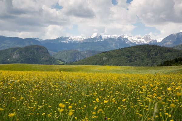
The tour encompasses a few short but steep ascends which will reward you with magnificent views and cycling between picturesque villages, where you will feel the pulse of the Slovenian countryside.
- Difficulty
-
medium
- Rating
-
- Starting point
-
Infocenter Triglavska roža Bled.
- Route
-
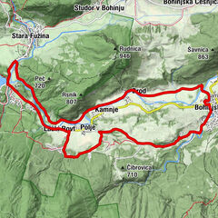
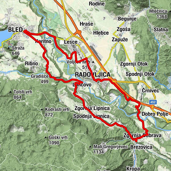
Bled0.2 kmKoritno1.3 kmBodešče3.2 kmNa Skali4.2 kmRadmannsdorf6.1 kmLancovo6.1 kmSelce6.7 kmZgornja Lipnica9.0 kmSpodnja Lipnica9.3 kmKamna Gorica11.3 kmGostilna Mlin11.7 kmZgornja Dobrava13.5 kmMišače14.6 kmGloboko15.6 kmGostilna Lectar20.3 kmOtroško igrišče20.6 kmRadmannsdorf20.8 kmBled27.6 km
- Best season
-
JanFebMarAprMayJunJulAugSepOctNovDec
- Description
-
You will explore interesting villages on the left shore of the Sava River. The tour starts past the villages of Bled and continues to the Sava Bohinjka River, where you cycle to Lancovo and come to the first climb. Continue below the Jelovica plateau to Kamna Gorica and return over Dobrava to Globoko. Cycle to Radovljica, where you can see the old city centre and return to Bled past the Šobec Campsite.
ATTENTION: The cycling trail between Bled and Radovljica is closed due to the construction of the roundabout at the Betin parking lot or directly next to the entrance to Bled. The roadblock is placed up to the intersection for the village of Koritno or up to the Sava river. From the direction of Bled towards Radovljica or Lesce, cyclists should therefore turn towards Koritno at the roundabout in front of the petrol station, and they can join the Bled – Lesce cycle trail below the village of Koritno. The same applies in the opposite direction.
- Directions
-
BLED - BODEŠČE - LANCOVO - KAMNA GORICA - DOBRAVA - GLOBOKO - RADOVLJICA - LESCE - BLED
The tour starts in front of the Triglavska roža Bled Info Centre and continues along the Ljubljanska cesta. In the roundabout, take the third exit. Follow the main road and continue towards Koritno. Continue cycling towards Bodešče. When you come to the village (on the left), turn left and descend to the Sava Bohinjka River and cross it. At the end of the bridge, the asphalt road turns to unpaved road, turn left and cycle along the river (on the left side).
When you reach Lancovo, you can already see Radovljica in the distance. In the crossroad, turn right and start a steep climb that ends after 500 metres in the crossroad at the roadside shrine (on the left). Turn left and cycle on the plane before you start climbing to the upper part of the village. Cycle along the main road through the village and when coming out of the village you reach the main rood through the valley of Lipnica. Turn right and cycle along the main road to Zgornja Lipnica in the direction of Kamna Gorica. When you come to the village, turn right (focus on direction signs for cyclists). Cycle through Kamna Gorica and along the main road through the village. At the east part of the village, turn right to the main road and continue towards Lipnica and Kropa.
You will notice a small pond on the left. When you come to the first turning on the left, turn left in the direction of Zg. Dobrava. You will start ascending steeply to the village and continue along the main road. Cycling signs are located along the route and direct you to Mošnje. You will start a slight descend at the end of the village, turn left and reach Mišače. Follow the signs for Globoko and descend to the bridge over the Sava River. When you come to Globoko, turn left under the railway track towards Mošnje. Start ascending to the motorway and Mošnje. Right before the motorway underpass, turn left and continue straight on along the road by the motorway (on the right).
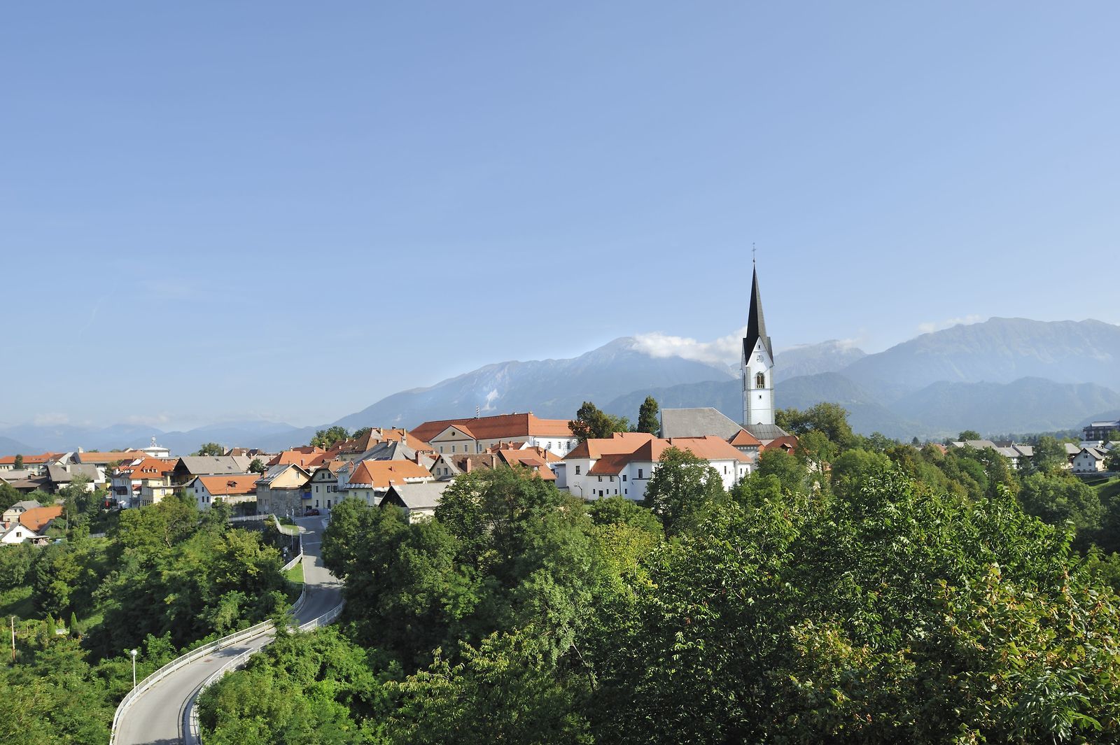
Descend along the asphalt road and after crossing a small bridge, you will reach unpaved road. This is a forest study path, continue along the main road through the forest (keep right in the crossroads and on the main unpaved road). After approximately two kilometres, you will reach the petrol station (on the right). Continue directly towards Radovljica and drive to Ljubljanska cesta. Continue straight on along Ljubljanska cesta. Drive past Mercator shop (on the right) and after a few hundred metres, turn left in Gubčeva ulica street, descend to the entry of the old city centre. This is followed by a short ascend, turn left and go past Lectar Inn to Linhartov trg square.
Continue in the main direction of the arrival to the old city centre and continue on the left side, i. e. along Gorenjska cesta road. Continue from Gorenjska cesta along the cycling route and on Kranjska cesta road to the semaphore crossroad and go straight on. When you arrive to the crossroad, take the third exit and continue straight on along the road that takes you under the railway track. After a short ascent, turn right in the crossroad to the cycling path and continue towards Lesce. Take the third exit in the first crossroad and start descending to Šobec Campsite. The descend is quite long and runs along a unpaved road, therefore, we recommend caution. Before you end your descend, you can notice the campsite area on the left.
Continue cycling along the asphalt road to the campsite and after approx. one kilometre you will come to the crossroad towards Bled. Turn left to the cycling route and continue to the bridge over the Sava Bohinjka River. Continue ascending along the cycling route to the Triglavska roža Info Centre in Bled.
- Highest point
- 506 m
- Endpoint
-
Infocenter Triglavska roža Bled.
- Height profile
-
 © outdooractive.com
 - Equipment
-
Bike and helmet
- Safety instructions
-
The tour is suitable for mountain, trekking and road bicycles.
Consider traffic signalisation. - Tips
-
If you are interested in the history of blacksmithing, we recommend you to visit Kropa, its museum and learn how the entire Lipnica Valley was related to blacksmithing in the past. Visit the Bee-keeping Museum in Radovljica and stop at one of the cafés.
- Additional information
-
TIC INFOCENTER Triglavska roža Bled
Ljubljanska cesta 27, SI – 4260 Bled
E-maili: info@visitbled.si , info.trb@tnp.gov.si
Tel: +386 (0)4 5780 205
Web address: http://www.bled.s i; http://www.tnp.si
TIC - Turistično Društvo Bled
Cesta svobode 10, SI – 4260 Bled
Tel: +386 (0)4 5741 122
Web address: http://www.td-bled.si
TIC Radovljica
Linhartov trg 9, SI - 4240 Radovljica
Tel: +386 (0)4 5315 112
- Directions
-
You can get to the starting point in Bled by car from Lesce (Ljubljana-Karavanke motorway exit) or from other regional roads from Bohinj or Jesenice.
- Public transportation
- Parking
- Author
-
The tour Below Jelovica to Radovljica is used by outdooractive.com provided.


General info
-
Wörthersee - Rosental
179
-
Gorenjska
22
-
Radovljica
27