Winter
Summer
Weather
Webcams
Accommodations
Tours
Search history
Search suggestions
No results found
Search
Tours
Home
Summer Slowenien
Gorenjska
Tours
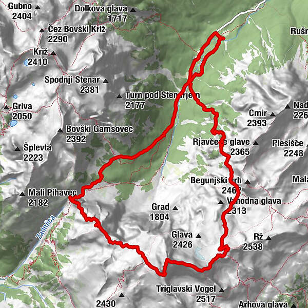
Triglav 2864m.gpx
Regions
Weather
Webcams
Tours
Highlights
Bathing lakes
Sports provider
Events
Ski resorts
Cross-country skiing
Snow parks
Triglav 2864m.gpx
Via ferrata
Bookmark
Map
show
hide
Print
Tour data
16.06
km
980 - 2,864
m
Distance
1,946
hm
1,869
hm
Ascent
12:10
h
Duration
Philip.
created am 11.08.2020
2,059
Views
Rating
Technique
Fitness
Landscape
Experience
Highest point
2,864 m
Rock quality
Write a review
Overall rating
5
0
%
4
0
%
3
0
%
2
0
%
1
0
%
Reviews
(0)
0 Comments
Write a review
Error
An error has occurred. Please try again.
Thank you for your review
Rating has been deleted
Report tour
GPS Downloads
GPX
GPS Exchange Format (XML)
KML
Google Earth, Google Maps
QR Download Codes for Mobile Phones
Triglav 2864m.gpx
QR Codes - tour download for cell phones
GPX
KML
Other tours in the regions
Region Villach - Faaker See - Ossiacher See
52
Goriška
28
Trenta
21
Popular tours in the area
Triglav Überschreitung 2.864m plus Kredarica 2.539m, Rz 2.538m, Beg...
difficult
Via ferrata
17.42
km |
2201
hm |
12:50
h
Rotschitza Klamm Klettersteig B/C
medium
Via ferrata
3.73
km |
280
hm |
01:34
h
Mangart (2679 m), Via Italiana
difficult
Via ferrata
8.14
km |
1011
hm |
04:30
h
Krn (2244 m), The Silvo Koren route
difficult
Via ferrata
18.87
km |
2792
hm |
08:30
h
No entries found.
The search is currently not available.
Please refine your search.
Local search results
(<= 25km)
More results
(> 25km)
%count% Search results
%name%
%type%
%elevation%
%population%
%lpButton%