- Difficulty level
- B

- Brief description
-
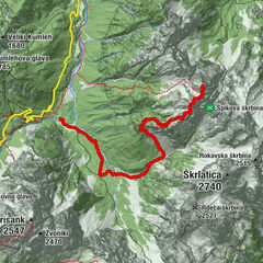
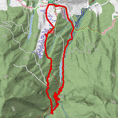
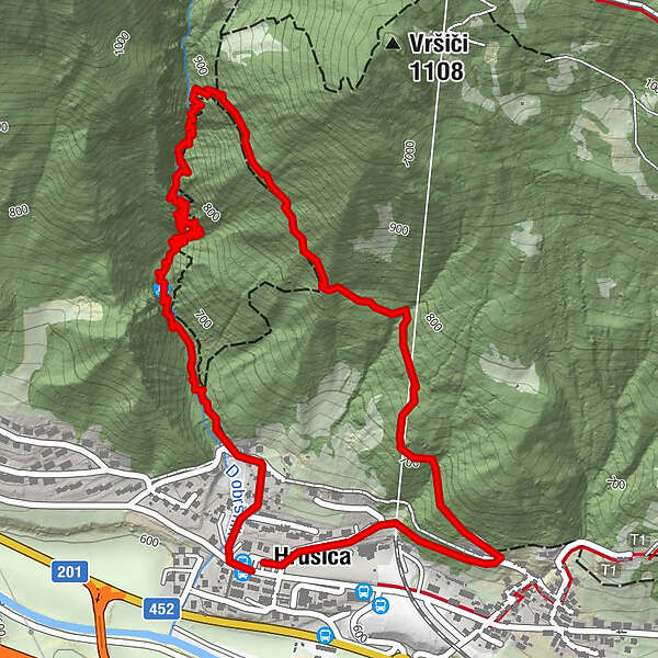
On Hrušica, the Dobršnik ferrata is available for all climbing enthusiasts The ferrata is located in a secluded, wild ravine of unspoiled nature, that climbs above Hrušica towards Karavanke. For a long time, the entire ravine was impassable. It is adorned by seven waterfalls. Numerous pools and troughs make the trail even more interesting. The map depicts the trail as a complete circle from the starting point (parking lot) to the return point.
- Difficulty
-
mediumDifficulty level B
- Rating
-
- Starting point
-
Ferrata Dobršnik - Hrušica Parking lot
- Route
-
Dobršniški slapovi0.8 kmBirnbaum3.9 km
- Best season
-
JanFebMarAprMayJunJulAugSepOctNovDec
- Description
-
The ferrata has a height difference of 270 metres, a route length of 1000 metres, and a southern orientation of the wall. Access takes 20 minutes, climbing 1 hour and 15 minutes, and descending 30 minutes. The ferrata is moderately difficult. Easier and more difficult sections alternate, and great caution is advised. It is rated as B difficult, with C near the top.
From October 31 to April 1, the secured route is CLOSED.
- Highest point
- 921 m
- Endpoint
-
Ferrata Dobršnik - Hrušica Parking lot
- Exposition
- Height profile
-
 © outdooractive.com
 - Equipment
-
Use of appropriate equipment is required, including appropriate footwear, clothing, a helmet, and a self-protection belt. The climbing route is not accessible to inexperienced climbers or minors who are not accompanied by an adult. Do not enter in cases of storms, snow, or at night. Danger of flooding! Never use the climbing route to descend. Descend along the marked forest path.
On prior agreement or reservation, some sets of self-protection equipment are also available (for a fee) at the nearby Trucker pizzeria.
- Directions
-
Ferrata Dobršnik - Hrušica Parking lot
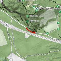
Take the last exit, Hrušica, off the highway heading towards the Karavanke tunnel. Turn right at the exit towards Jesenice and, after about 500 metres, turn left uphill at the roundabout. Turn left along the priority road at the top of the slope. Notice the "Ferrata Dobršnik Parking Lot" sign after 200m of driving, on the right side in front of the bus station. Park your car in a designated area. Follow the yellow "Ferrata Dobršnik" signposts from the parking lot behind the apartment building. The path takes us uphill straight through the right bend. Choose the road to the left between the houses at the top of the slope, and 50m before the stream, behind the last house on the right, turn onto the dirt road into the forest. At the crossroads, take the lower left path that runs along the stream. A red arrow indicates the path into the Dobršnik gorge. The path crosses the riverbed several times, and in some places, it is less well-trodden. The information board "Gorge - Ferrata Dobršnik" provides access to the ferrata. It takes 20 minutes to get from the starting point to the ferrata entrance.
The climbing route is not accessible to inexperienced climbers or minors who are not accompanied by an adult. Do not enter in cases of storms, snow, or at night. Danger of flooding!
Descent
Descend along the marked forest path. We turn right back into the valley when we reach the forest path that climbs towards Rogarjev rovt. Follow the marked path back to the starting point. It will take us 30 minutes to return to the valley. Never use the climbing route to descend.
- Parking
-
Ferrata Dobršnik - Hrušica Parking lot
-
-
AuthorAlpe Adria Erlebnis-RegionThe tour Ferata Dobršnik is used by outdooractive.com provided.