
- Brief description
-
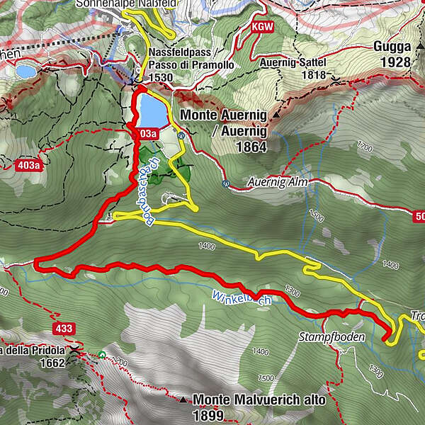
The trail starts there where the ”Livio Trail“ ends, thus directly at the shores of Lago Pramollo (Lake Nassfeld).
- Difficulty
-
easy
- Rating
-
- Best season
-
JanFebMarAprMayJunJulAugSepOctNovDec
- Description
-
This trail is entirely on Italian territory.
Across meadows and a wooden bridge, you ride downhill to the old Italian barracks. You then follow a gravel path in direction Winkelalm. It pays to take the short uphill section to the Winkelalm because this place is very special. It is not only a perfect photo point but is also ideal for a short break or a picnic. On your way back, turn towards south before the Winkelalm. Apart from two interlocked sections, the trail continues flowy from here. The end of the trail leads on a gravelled forest road to the ”Stamboden“. From here it’s only around 800 m to the serviced Tratten Alm (Malga Tratten). As there is no lift uphill on the way back, you have to ride across the asphalted pass road for approx. 3 km back to the starting point and you have to manage around 250 altitude metres. But this makes the trail ideal for all E-bikers. If you want, you can use the shuttle bus (for a fee) to return from the Tratten Alm (calling 04285/7100 in advance to book the shuttle bus is absolutely necessary!).
- Directions
-
Parking at the state border
- Highest point
- 1,527 m
- Endpoint
-
kurz vor der Tratten Alm... Holzlagerplatz
- Height profile
-
 © outdooractive.com
 - Equipment
-
Fully with 130 mm travel recommended, technically well versed bikers have fun with their hardtail as well.
- Safety instructions
-
Approximately at the middle there are a few passages where the old freight road has large stones. Please be careful.
- Tips
-
No mountain railway connection. Return via the Nassfeld pass road. 3 kilometres, approx. 250 metres altitude difference
- Directions
-
Approach via the B111 to the Tröpolach junction. Here take the B90 Nassfeld-Pass road. Follow this road to the Madritschen Sessalbahn valley station at Nassfeld.
- Public transportation
-
Journey to Tröpolach by public transport possible.
www.nassfeld.at/mobilitaet
The 3 summer mountain railways at Nassfeld take you to the starting points of the various trails. And that, for example, with the MTB experience day ticket, as often as you like.
There is no direct mountain railway connection on this trail!
- Parking
-
Parking spaces are available at the Madritschen chairlift valley station on the Nassfeld Pass!

- Author
-
The tour Nassfeld Singletrail Italy is used by outdooractive.com provided.