Winter
Summer
Weather
Webcams
Accommodations
Tours
Search history
Search suggestions
No results found
Search
Hiking
Home
Summer Schweiz
Bernese Oberland
Tours
Hiking
Hiking
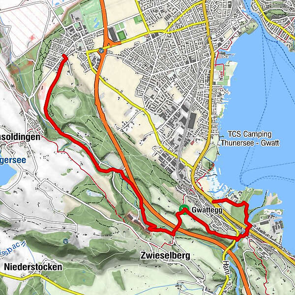
Wasser-Idylle und Panorama-Sicht am Thuner Stadtrand
Regions
Weather
Webcams
Tours
Highlights
Bathing lakes
Accommodations
Offers
Sports provider
Events
Ski resorts
Cross-country skiing
Snow parks
Wasser-Idylle und Panorama-Sicht am Thuner Stadtrand
Hiking
Map
Hide map
Bookmark
Add page to favorites
To save pages in favorites, log in or create a free account.
Login
Register
Print
Which problem do you want to report on this tour?
Reason
Not accessible
Inappropriate (hate speech, insulting, or sexually explicit language).
Spam
Violation of privacy
Copyright infringement
Incorrect information
Other
Explanatory notes
E-Mail
Report
Berner Wanderwege
Tour data
8.03
km
558 - 649
m
Distance
46
hm
67
hm
Ascent
02:10
h
Duration
Berner Wanderwege
Reviews
(0)
0 Comments
Write a review
Error
An error has occurred. Please try again.
Thank you for your review
Rating has been deleted
GPS Downloads
GPX
GPS Exchange Format (XML)
KML
Google Earth, Google Maps
QR Download Codes for Mobile Phones
Wasser-Idylle und Panorama-Sicht am Thuner Stadtrand
QR Codes - tour download for cell phones
GPX
KML
General info
Refreshment stop
Other tours in the regions
Thunersee
1064
Amsoldingen
205
Popular tours in the area
Sieben Hengste
difficult
Hiking
13.71
km |
985
hm |
05:05
h
Oberhofen - Niesenbänkli hoch über den Thunersee
medium
Hiking
8.72
km |
592
hm |
03:25
h
Niederhorn-Burgfeldstand-Gemmenalphorn-Justistal-Beatenberg
medium
Hiking
18.12
km |
1143
hm |
05:30
h
Aeschiried - Suldtal - Pochtenfall - Brunni - Greberegg - Aeschiried
medium
Hiking
13.8
km |
880
hm |
04:45
h
No entries found.
The search is currently not available.
Please refine your search.
Local search results
(<= 25km)
More results
(> 25km)
%count% Search results
%name%
%type%
%elevation%
%population%
%lpButton%