Grindelwald: The scent of blossoms and a blaze of colour at Pfingstegg


- Brief description
-
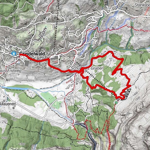
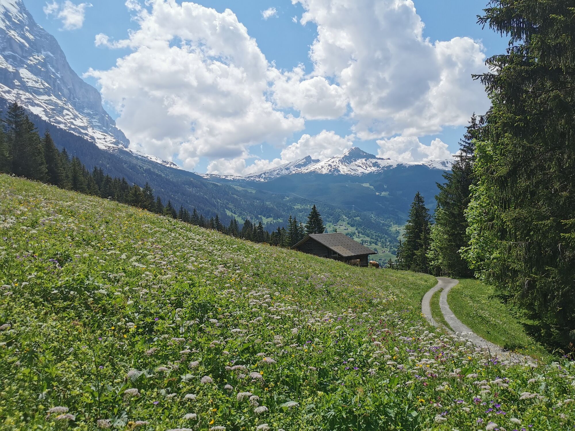
The Pfingstegg offers the most comprehensive view of Grindelwald's extensive valley. A circular hike to the viewing balcony leads through cool mountain forests and across flower-filled meadows and pastures.
- Difficulty
-
easy
- Rating
-
- Starting point
-
Grindelwald
- Route
-
Grindelwald0.2 kmPfingstegg2.5 kmGrindelwald6.2 km
- Best season
-
JanFebMarAprMayJunJulAugSepOctNovDec
- Description
-
There is a cable car from Grindelwald to Pfingstegg. Nevertheless, it is worth foregoing the comfortable journey and tackling the path to the viewing balcony on foot.
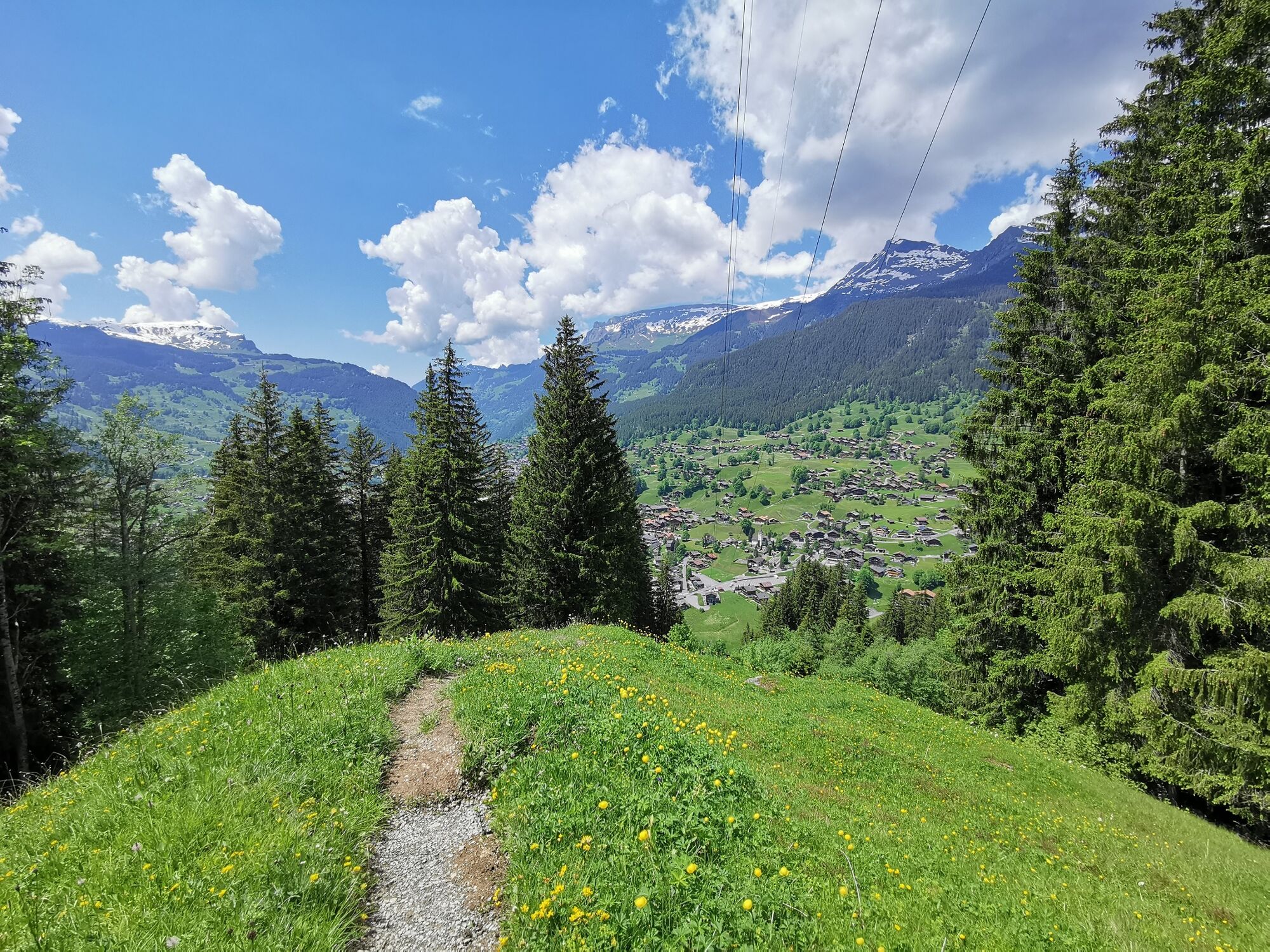
From the Mättenberg bridge, a narrow footpath winds steeply upwards between the trees. After a while you leave the forest and the path continues upwards through flower-filled meadows and pastures. Here the Pfingstegg stretches out. Close-up and distant views form a harmonious landscape composition: a few small barns covered with wooden shingles contrast wonderfully with the magnificent view of the valley. This idyllic spot offers enchanting charms not only at Whitsun, but also in spring and summer. In 2005 it was awarded the cultural landscape prize of the Oberland-Ost region.
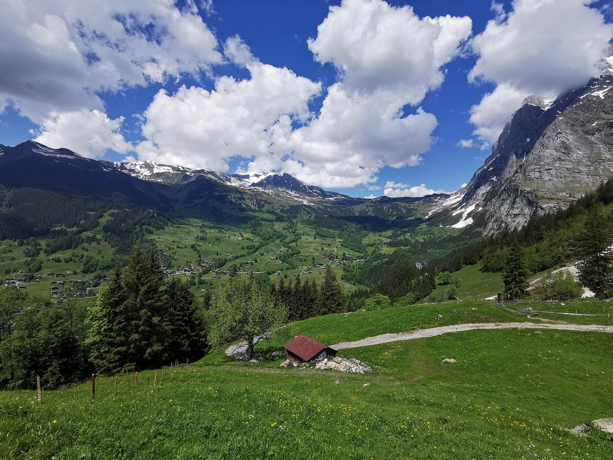
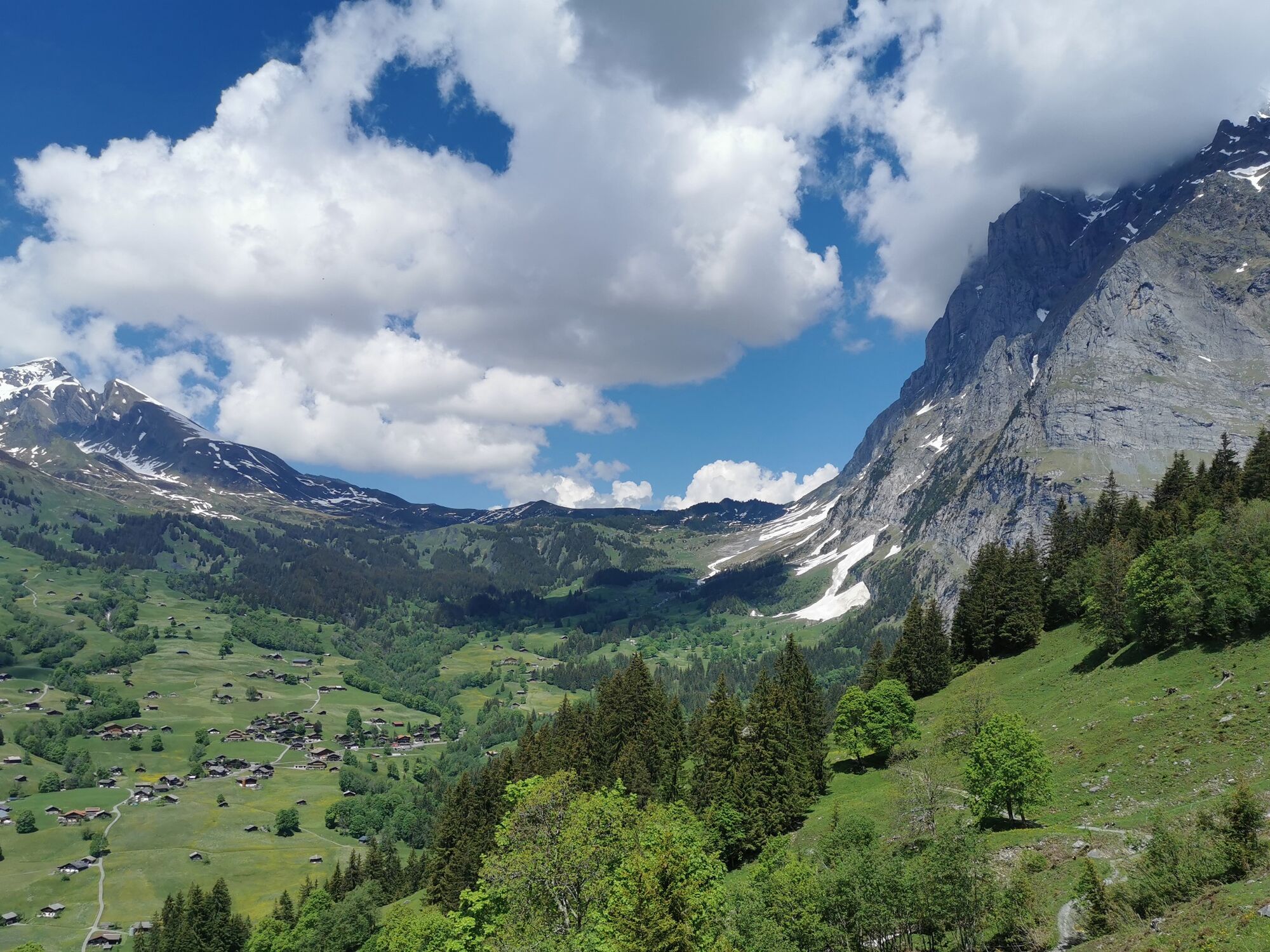
The descent via Sulz winds its way down the valley on a gravel road. You pass alternately through pastureland and shady mountain forest, with the mighty north face of the Wetterhorn towering into the sky in the background.
- Highest point
- 1,374 m
- Endpoint
-
Grindelwald
- Height profile
-
 © outdooractive.com
 - Equipment
-
The sun's rays are particularly intense in the mountains. Sun cream with a high protection factor, a sun hat and sunglasses with UV protection should therefore be part of your luggage. Even in summer and in good "starting weather", warm clothing and rain protection are part of the equipment. The onion principle with several layers of clothing is recommended. Day hiking backpack with rain cover Sturdy and comfortable shoes Clothing adapted to the weather and hard-wearing (onion principle) Charged mobile phone Pocket pharmacy Beverages and food Pocket knife
mobile phone
if necesessary: telescope sticks, headlight, maps
- Safety instructions
- Tips
-
Motivation boost for children: In addition to the restaurant, Pfingstegg also has a summer toboggan run and a large Tyrolienne.
- Directions
-
From Basel and Geneva, the fastest route to the Jungfrau Region is via Bern. From Zurich, the route via Lucerne and the Brünig Pass is recommended. The pass is open all year round.
From the south, travel to the Jungfrau Region via the Grimsel or Susten Pass. Both passes are only open in summer. An alternative is the Simplon Pass with subsequent car transport through the Lötschberg tunnel.
Grindelwald
From Interlaken we follow the main road to Zweilütschinen. Here we turn left towards Grindelwald. The whole trip takes about 30 minutes and leads over a partly winding road.
- Public transportation
-
Thanks to its central location in Europe, Switzerland is served by international trains from over 12 countries. Within Switzerland, Intercity trains run from Basel and Lucerne directly to the Jungfrau Region. Travellers from Zurich change trains in Bern. The trains run every half hour.
Grindelwald
From Interlaken Ost railway station we reach Grindelwald without changing trains on the Bernese Oberland Bahn (BOB). Important: Get on the rear part of the train, as it splits in Zweilütschinen. If you get on at the front, you will end up in Lauterbrunnen. The journey takes 30 minutes to Grindelwald Terminal (V-Bahn). Three minutes later we are at the terminal in the village.
There are three stations in Grindelwald (Terminal, Grund and Dorf). The terminal station (Dorf) is in the centre of Grindelwald
- Parking
-
Grindelwald
There are three public car parks: Parkhaus Eiger+ (252 parking spaces), Parkhaus Sportzentrum (160 parking spaces) and the new Terminal Parking (1000 spaces) of the V-Bahn. Alternatively, we can also use the car park in Grindelwald Grund.


- Author
-
The tour Grindelwald: The scent of blossoms and a blaze of colour at Pfingstegg is used by outdooractive.com provided.


-
Aletsch Arena
1496
-
Jungfrau Region
1033
-
Grindelwald - First
399


