- Brief description
-
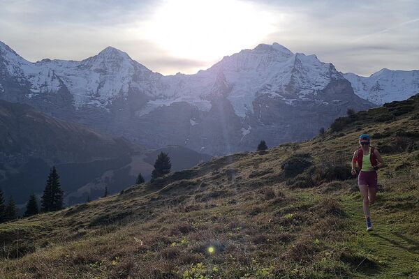
A sporty trail route with a long ascent to Männlichen.
- Difficulty
-
difficult
- Rating
-
- Starting point
-
Grindelwald sports centre
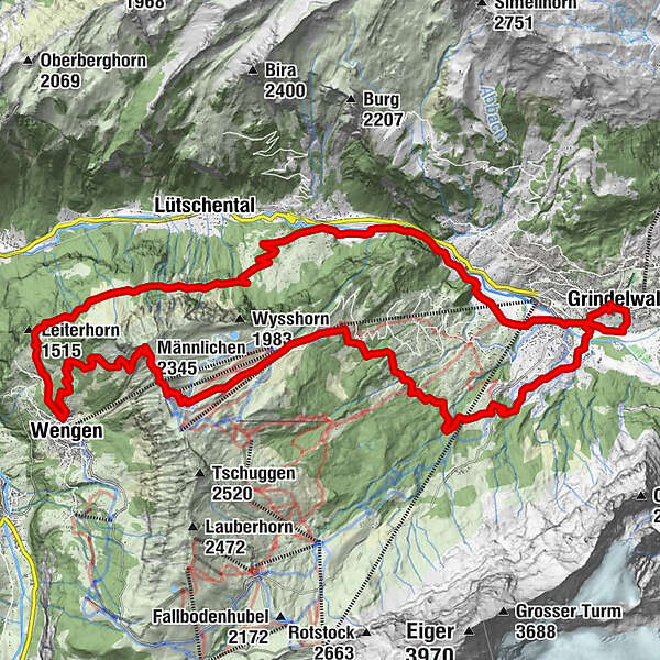
- Route
-
GrindelwaldSchwendi3.2 kmBurglauenen5.8 kmUfen Ritten8.5 kmSpäteli10.1 kmFlühla12.8 kmAn der Ledi12.8 kmFlühlenboden13.1 kmGruebiweidli13.3 kmBorter13.4 kmAuf dem Bühl13.4 kmGalliweidli13.4 kmAuf der Burg13.5 kmWengen13.5 kmSchilt13.5 kmBodendiehle13.5 kmSchleif13.6 kmStutzera13.7 kmMossenegg17.6 kmMännlichen (2,345 m)17.7 kmMännlichen (2,230 m)18.3 kmMännlichen (2,225 m)18.5 kmBerghaus Männlichen18.5 kmBrandegg-Bidemmeder26.0 kmGrindelwald30.4 km
- Best season
-
JanFebMarAprMayJunJulAugSepOctNovDec
- Description
-
This trail follows the Eiger Ultra Trail routes E101 and E35 which wind their wicked way up from Burglauenen to Wengen and finally Männlichen. Already upon reaching Wengen, the snowy peaks of the Jungfrau massif loom into view and the seemingly relentless Gemsweg releases you onto the Männlichen ridge. From here you have the option to take the cableway down to the village or to descend on foot to the mid-station Holenstein and catch it from there. Continuing on foot, the pleasantly undulating Öpfelchüechliweg trail rewards you with its famous homemade offerings of the best Öpfelchuechli apple fritters in the world at the Brandegg restaurant. Energy restored, the last short leg brings you to the valley floor!
- Directions
-
Village – Burglauenen – Wengen – Männlichen – Holenstein – Brandegg – Grund - village
- Highest point
- 2,331 m
- Endpoint
-
Grindelwald sports centre
- Height profile
-
 © outdooractive.com
 - Equipment
-
First Aid Kit
Weather-appropriate clothing (always carry waterproofs)
Drink/food provisions
Mobile phone - Safety instructions
-
Danger of overflowing waterways in heavy rainfall
snow patches in spring
Caution advised in thunderstorms - Tips
-
Free running shoe test at the Backdoor Shop Grindelwald
- Additional information
- Directions
-
From Basel and Geneva, the fastest route to the Jungfrau Region is via Bern. From Zurich, the route via Lucerne and the Brünig Pass is recommended. The pass is open all year round.
From the south, travel to the Jungfrau Region via the Grimsel or Susten Pass. Both passes are only open in summer. An alternative is the Simplon Pass with subsequent car transport through the Lötschberg tunnel.
Grindelwald
From Interlaken we follow the main road to Zweilütschinen. Here we turn left towards Grindelwald. The whole trip takes about 30 minutes and leads over a partly winding road.
Wengen
Wengen is car-free. If we arrive by car, we have to leave it in Lauterbrunnen and take the train. The journey from Interlaken to Lauterbrunnen takes about 20 minutes.
- Public transportation
-
Thanks to its central location in Europe, Switzerland is served by international trains from over 12 countries. Within Switzerland, Intercity trains run from Basel and Lucerne directly to the Jungfrau Region. Travellers from Zurich change trains in Bern. The trains run every half hour.
Grindelwald
From Interlaken Ost railway station we reach Grindelwald without changing trains on the Bernese Oberland Bahn (BOB). Important: Get on the rear part of the train, as it splits in Zweilütschinen. If you get on at the front, you will end up in Lauterbrunnen. The journey takes 30 minutes to Grindelwald Terminal (V-Bahn). Three minutes later we are at the terminal in the village.
There are three stations in Grindelwald (Terminal, Grund and Dorf). The terminal station (Dorf) is in the centre of Grindelwald.
Wengen
From Interlaken Ost station we reach Wengen in 44 minutes. The blue and yellow train of the Berner Oberland Bahn (BOB) takes us to Lauterbrunnen. Important: We sit in the front part of the train, as it splits in Zweilütschinen. If you take a seat at the back, you will make a detour to Grindelwald. In Lauterbrunnen we change to the yellow-green train of the Wengernalp Bahn (WAB). This takes us to Wengen in 12 minutes.
- Parking
-
Grindelwald
There are three public car parks: Parkhaus Eiger+ (252 parking spaces), Parkhaus Sportzentrum (160 parking spaces) and the new Terminal Parking (1000 spaces) of the V-Bahn. Alternatively, we can also use the car park in Grindelwald Grund.
Wengen
There is a multi-storey car park directly below Lauterbrunnen station. Alternatively, you can use the car park at the Lauterbrunnen church. From here, a bus leaves for the station every half hour. On foot we need about 10 minutes.
A covered passage leads from the Lauterbrunnen car park to the cable cars to Wengen.
- Author
-
The tour At the foot of the mountain trio No. 31 is used by outdooractive.com provided.