© Erlebnismacher AG - #wirsindofflinehelden - Denise Krieg

© Erlebnismacher AG - #wirsindofflinehelden - Denise Krieg

© Erlebnismacher AG - #wirsindofflinehelden - Denise Krieg

- Brief description
-
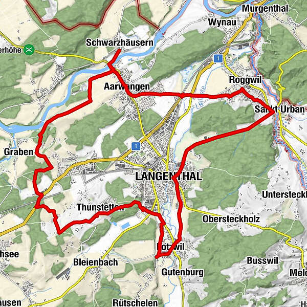
Der östliche Oberaargau ist ein Ausflug mit dem Velo wert. Kleine Dörfer, Wässermatten und die Aare laden zum Verweilen ein.
- Difficulty
-
medium
- Rating
-
- Route
-
Schwarzhäusern (427 m)Gasthof zum Bären0.5 kmMeiniswil3.4 kmGsoll4.2 kmSchörlishäusern4.9 kmBützberg6.0 kmWeissenried7.3 kmLochstauden8.5 kmSpeiserestaurant Forst9.1 kmForst9.1 kmHolz9.5 kmThunstetten (504 m)11.4 kmIm Moos14.4 kmLotzwil (502 m)16.0 kmBahnhof16.0 kmKreuz16.3 kmLangenthal (481 m)18.6 kmSankt Urban (445 m)23.1 kmBergweiher24.2 kmRoggwil (421 m)24.5 kmKaltenherberge26.0 kmAarwangen (437 m)29.0 kmGasthof zum wilden Mann29.2 kmRef. Kirche Aarwangen29.6 kmGasthof zum Bären30.2 kmSchwarzhäusern (427 m)30.7 km
- Best season
-
JanFebMarAprMayJunJulAugSepOctNovDec
- Highest point
- 524 m
- Endpoint
-
nach belieben
- Height profile
-
 © outdooractive.com


-

-
AuthorThe tour östlicher Oberaargau is used by outdooractive.com provided.
GPS Downloads


General info
Refreshment stop
Other tours in the regions
-
Solothurn und Region
142
-
Oberaargau
87
-
Langenthal
27