- Brief description
-
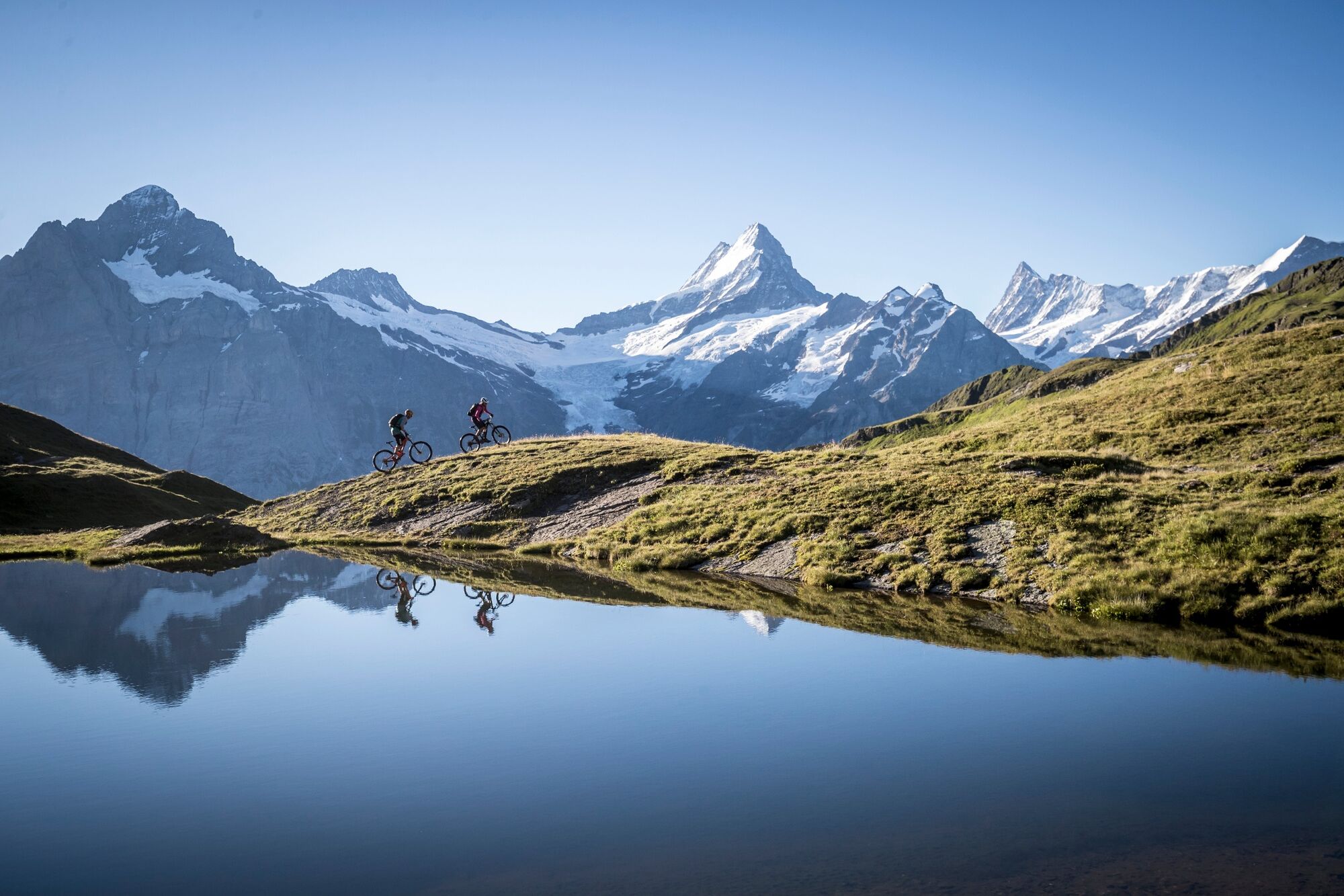
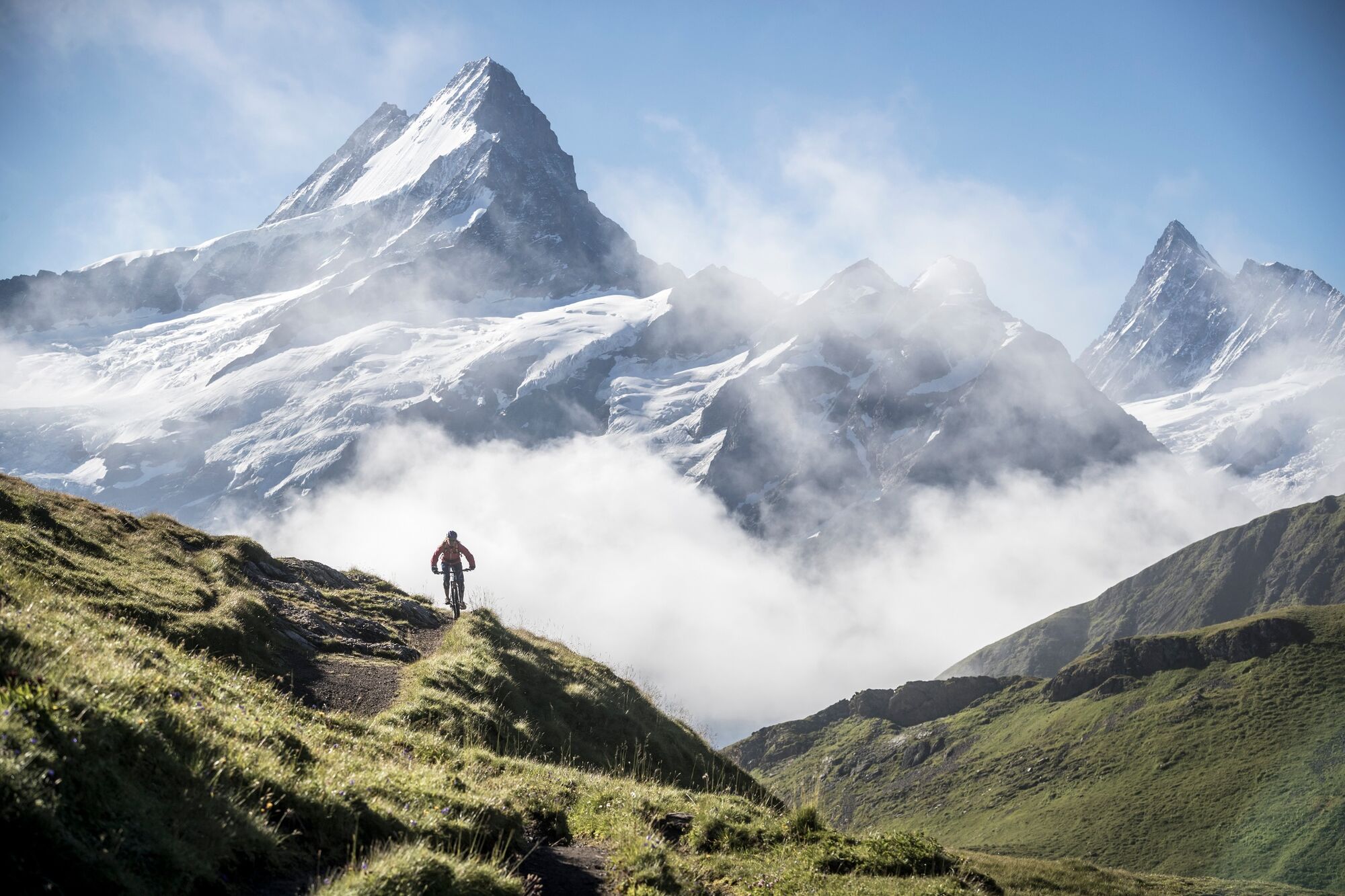
Varied single trail with unique mountain panorama
- Difficulty
-
difficult
- Rating
-
- Starting point
-
Grindelwald Railway station
- Route
-
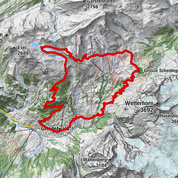
Grindelwald0.2 kmDorfkirche0.9 kmStählisboden3.0 kmBlümlisalp3.4 kmIschboden-Hütte5.5 kmGrosse Scheidegg (1,962 m)10.6 kmAlp Grindel13.8 kmFirst (Oberjoch) (2,164 m)16.2 kmBachlägerwasserfall21.6 kmBerggasthaus Waldspitz22.3 kmNodhalten24.8 kmTuftbach29.2 kmSwiss Alp Resort29.9 kmGrindelwald30.1 km
- Best season
-
JanFebMarAprMayJunJulAugSepOctNovDec
- Description
-
This trail is suitable for trail beginners and advanced, but already require an advanced mountain bike riding technique and trailer experience. A good balance with weight shifting to overcome obstacles, step riding, as well as a safe cornering and braking technique are necessary.
Since summer 2018, the mountain bike trail at Lake Bachalp - Grindelwald is officially signposted. First, however, you’ll have to conquer the ascent from Grindelwald. The asphalt pass road leads to Grosse Scheidegg. It continues on a gravel road to First and Lake Bachalp. Once you reach the top, it's time for a bite and a break to take in the breath-taking snow-covered peaks of the Bernese Alps. Once your break is over, you will then take the 13 km descent. It is a mix of rock slabs, stepped passages, meadows and woods on the 1,200 metres downhill. The trail, overall, is mostly smooth to ride.
- Directions
-
Grindelwald - Grosse Scheidegg - First - Bachalpsee - Bachläger - Waldspitz - Grindelwald
- Highest point
- 2,276 m
- Endpoint
-
Grindelwald Railway station
- Height profile
-
 © outdooractive.com
 - Equipment
-
(E-) mountainbike, well maintained Helmet, gloves, cycling glasses & bell Elbow & knee pads Mountain bike shoes Weather appropriate & durable clothing Day bike backpack Drink & food Repair Kit First aid kit Cell phone Map
- Safety instructions
-
Considerate and safe - Bike Codex
Wear protective equipment Evaluate your skills Give way to hikers Stay on the trail Close pasture fences - Tips
-
The ascent to the Grossen Scheidegg or First is also possible by bus or gondola
Sun terrace of the restaurant Waldspitz - Additional information
- Directions
-
From Basel and Geneva, the fastest route to the Jungfrau Region is via Bern. From Zurich, the route via Lucerne and the Brünig Pass is recommended. The pass is open all year round.
From the south, travel to the Jungfrau Region via the Grimsel or Susten Pass. Both passes are only open in summer. An alternative is the Simplon Pass with subsequent car transport through the Lötschberg tunnel.
Grindelwald
From Interlaken we follow the main road to Zweilütschinen. Here we turn left towards Grindelwald. The whole trip takes about 30 minutes and leads over a partly winding road.
- Public transportation
-
Thanks to its central location in Europe, Switzerland is served by international trains from over 12 countries. Within Switzerland, Intercity trains run from Basel and Lucerne directly to the Jungfrau Region. Travellers from Zurich change trains in Bern. The trains run every half hour.
Grindelwald
From Interlaken Ost railway station we reach Grindelwald without changing trains on the Bernese Oberland Bahn (BOB). Important: Get on the rear part of the train, as it splits in Zweilütschinen. If you get on at the front, you will end up in Lauterbrunnen. The journey takes 30 minutes to Grindelwald Terminal (V-Bahn). Three minutes later we are at the terminal in the village.
There are three stations in Grindelwald (Terminal, Grund and Dorf). The terminal station (Dorf) is in the centre of Grindelwald.
- Parking
-
Grindelwald
There are three public car parks: Parkhaus Eiger+ (252 parking spaces), Parkhaus Sportzentrum (160 parking spaces) and the new Terminal Parking (1000 spaces) of the V-Bahn. Alternatively, we can also use the car park in Grindelwald Grund.

- Author
-
The tour «Bachalpsee» Loop is used by outdooractive.com provided.
Surfaces
General info
-
Obwalden
170
-
Jungfrau Region
64
-
Grindelwald - First
18