


- Brief description
-
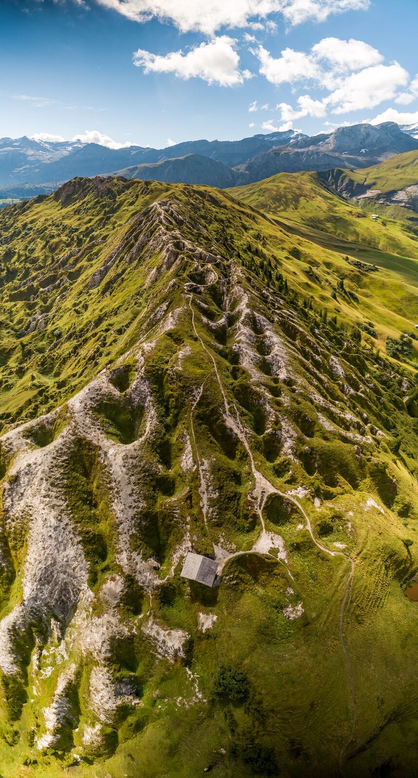
The Betelberg harbours a fascinating site with extraordinary scenery: the "Gryden". The catchphrase for the Gryden high-altitude circular trail: Hike – marvel – enjoy!
- Difficulty
-
easy
- Rating
-
- Route
-
Berghaus Leiterli0.0 kmBerghaus Leiterli7.2 km
- Best season
-
JanFebMarAprMayJunJulAugSepOctNovDec
- Description
-
This hike starts off from the Betelberg gondola lift ("Leiterli"). The first section of the mountain trail leads along the "Leiterli" alp circular trail on which walkers will encounter an interesting mix of unique information and adventure stations. The path leads mostly along flat or slightly undulating ground towards Steinstoss. On the first section, the trail affords a magnificent view of the "Haslerberg Moorland", a protected moorland that has been listed since 1996 in the Federal Inventory of Mire Landscapes of Particular Beauty and National Importance.
The finest Alpine cheese is produced on and around the Steinstoss alp. From here onwards, path becomes narrower and offers up a breathtaking view of what is probably the most beautiful valley closure in the Alps. Then, the path leads over the "Stübleni" limestone formation in a short, steeper climb. A bizarre "Gryden" crater-like, rocky landscape spreads out on its northern side. The extraordinarily rocky landscape in the Stübleni region is not only fascinating for geologists and biologists, but for everyone who finds themselves enthralled by a unique landscape. Its highest point gives you an unbelievable panoramic view that, in clear weather, extends from the Simmental across the Saanenland to the beautiful mountainous regions around Freiburg. The path now leads down to the turning point of this circular hike. At the turning point, undertaking a short side trip toward the "Schutzhütte" (mountain refuge) is worthwhile. Stop, take a deep breath and enjoy is the catchphrase now. It's best to stop briefly to fully appreciate and take in the crater-like landscape which resembles the moon's surface. The path to the mountain shelter winds its way past these depressions. If you decide to venture along this additional loop, you will need surefootedness and a head for heights. If you continue along the path, you will reach the Trütlisberg Pass which is the gateway to the Saanenland.
Having returned to the turning point, the southern portion of the Gryden circular trail again leads back to Steinstoss. On the last section of the trail from Steinstoss to the top station of the Betelberg gondola lift, you will have the option of finishing the Leiterli alp circular trail or making a side trip along the original Alpine flower trail. The Alpine flower trail on the Leiterli allows you to experience a natural diversity of plants that is rare to encounter now. Especially in July, when Alpine roses blossom and up to 70 other Alpine flowers are in bloom, the Alpine flower trail becomes a feast for the eyes.
Having returned to the starting point of the hike, a host of different attractions of the Betelberg Alpine experience await to be discovered by young and old. The Leiterli mountain hotel with its large sun terrace invites you to linger after the rigours of this circular hike. A delicious afternoon snack platter or an Alpine herb soup will become well-deserved sustenance.
- Highest point
- 2,093 m
- Endpoint
-
Betelberg / Leiterli
- Height profile
-
 © outdooractive.com
 - Equipment
-
We recommend the following items: light trekking shoes, light rucksack, sun protection, rain jacket, first-aid kit, light picnic, enough liquid, mobile phone.
- Safety instructions
-
The route leads exclusively along signposted mountain hiking trails. The themed trail is signposted by white directional signs and a green themed trail marker.
- Tips
-
The descent into the village of Lenk can also be completed on state-of-the-art "Trottibike" scooters, instead of by gondola lift. The 9-km-long scooter descent largely runs along paved roads into the village via Pöschenried.
- Directions
-
Travel by car to Lenk via Zweisimmen. At the roundabout in the centre of the village, turn off towards the valley station of the Betelberg gondola lift.
- Public transportation
-
Getting there: by train to Lenk via Zweisimmen. On foot or by local bus to the bottom station of the Betelberg gondola lift. Then by the Betelberg gondola lift from Lenk to the Leiterli top station.
Getting back: Walk to Lenk train station from the bottom station of the gondola lift. Then travel onwards by rail.
- Parking
-
There are ample free parking spaces at the bottom station of the gondola lift.


-

-
AuthorThe tour Gryden High-Altitude Circular Trail is used by outdooractive.com provided.


General info
-
Thyon les Collons
1426
-
Destination Gstaad
729
-
Lenk im Simmental
291


